Cannon County, Tennessee
| Cannon County, Tennessee | |
|---|---|
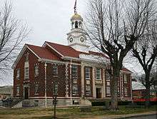 Cannon County Courthouse, Woodbury | |
|
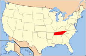
Location in the U.S. state of Tennessee | |
 Tennessee's location in the U.S. | |
| Founded | January 31, 1836 |
| Named for | Newton Cannon[1] |
| Seat | Woodbury |
| Largest town | Woodbury |
| Area | |
| • Total | 266 sq mi (689 km2) |
| • Land | 266 sq mi (689 km2) |
| • Water | 0.06 sq mi (0 km2), 0.02% |
| Population | |
| • (2010) | 13,801 |
| • Density | 52/sq mi (20/km²) |
| Congressional district | 6th |
| Time zone | Central: UTC-6/-5 |
| Website |
www |
Cannon County is a county located in the U.S. state of Tennessee. As of the 2010 census, the population was 13,801.[2] Its county seat is Woodbury.[3]
Cannon County is part of the Nashville-Davidson-Murfreesboro-Franklin, TN Metropolitan Statistical Area.
History
Cannon County was established by the Tennessee state legislature on January 31, 1836. It was formed from portions of Rutherford, Smith, and Warren counties and was named for Governor Newton Cannon. This was part of the Middle Tennessee region, with mixed farming and livestock raising, including of thoroughbred horses. There were more slaveholders here than in Eastern Tennessee.
Geography
According to the U.S. Census Bureau, the county has a total area of 266 square miles (690 km2), of which 266 square miles (690 km2) is land and 0.06 square miles (0.16 km2) (0.02%) is water.[4]
Adjacent counties
- DeKalb County (northeast)
- Warren County (east)
- Coffee County (south)
- Rutherford County (west)
- Wilson County (northwest)
State protected areas
- Headwaters Wildlife Management Area
- Short Mountain State Natural Area
Demographics
| Historical population | |||
|---|---|---|---|
| Census | Pop. | %± | |
| 1840 | 7,193 | — | |
| 1850 | 8,982 | 24.9% | |
| 1860 | 9,509 | 5.9% | |
| 1870 | 10,502 | 10.4% | |
| 1880 | 11,859 | 12.9% | |
| 1890 | 12,197 | 2.9% | |
| 1900 | 12,121 | −0.6% | |
| 1910 | 10,825 | −10.7% | |
| 1920 | 10,241 | −5.4% | |
| 1930 | 8,935 | −12.8% | |
| 1940 | 9,880 | 10.6% | |
| 1950 | 9,174 | −7.1% | |
| 1960 | 8,537 | −6.9% | |
| 1970 | 8,467 | −0.8% | |
| 1980 | 10,234 | 20.9% | |
| 1990 | 10,467 | 2.3% | |
| 2000 | 12,826 | 22.5% | |
| 2010 | 13,801 | 7.6% | |
| Est. 2015 | 13,840 | [5] | 0.3% |
| U.S. Decennial Census[6] 1790-1960[7] 1900-1990[8] 1990-2000[9] 2010-2014[2] | |||
As of the census[11] of 2000, there were 12,826 people, 4,998 households, and 3,643 families residing in the county. The population density was 48 people per square mile (19/km²). There were 5,420 housing units at an average density of 20 per square mile (8/km²). The racial makeup of the county was 96.87% White, 1.46% Black or African American, 0.33% Native American, 0.12% Asian, 0.02% Pacific Islander, 0.40% from other races, and 0.81% from two or more races. 1.22% of the population were Hispanic or Latino of any race.
There were 4,998 households out of which 33.30% had children under the age of 18 living with them, 58.60% were married couples living together, 9.90% had a female householder with no husband present, and 27.10% were non-families. 24.30% of all households were made up of individuals and 10.90% had someone living alone who was 65 years of age or older. The average household size was 2.53 and the average family size was 2.99.
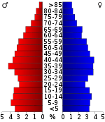
In the county, the population was spread out with 25.40% under the age of 18, 8.30% from 18 to 24, 28.90% from 25 to 44, 23.70% from 45 to 64, and 13.70% who were 65 years of age or older. The median age was 37 years. For every 100 females there were 96.30 males. For every 100 females age 18 and over, there were 93.20 males.
The median income for a household in the county was $32,809, and the median income for a family was $38,424. Males had a median income of $28,659 versus $21,489 for females. The per capita income for the county was $16,405. About 9.60% of families and 12.80% of the population were below the poverty line, including 14.00% of those under age 18 and 17.80% of those age 65 or over.
Government
The policy making and legislative authority in Cannon County is vested in the Board of County Commissioners. Commissioners are elected to four-year terms by a simple majority of the residents in their district. Each district has two commissioners and all 10 seats are up for election at the same time. Commissioners set personnel policies for the county, appropriate funds for County departments and set the property tax rate. The county mayor, typically, serves as chair of the County Commission and breaks a tie if one occurs during voting. Members typically meet in January, April, July and October with special call meetings taking place when necessary.
County Officials:
- County Executive: Mike Gannon
- Sessions Court Judge: Susan Melton
- Circuit Court Clerk: Lynne D. Foster
- County Clerk: Bobby Smith
- Clerk & Master: Nathan S. Nichols
- Register of Deeds: Sandy Hollandsworth
- Property Assessor: Donald Preston
- Trustee: Norma Knox
- Sheriff: Darrell Young
- Constable 1st District: None
- Constable 2nd District: Charles Nokes
- Constable 3rd District: None
- Constable 4th District: None
- Constable 5th District: None
Each official is elected to a 4-year term. With the exception of the tax assessor, the terms of most of the officials above will end on September 1, 2018. The tax assessor's term will end on September 1, 2016. The general sessions judge is elected to an 8-year term and the clerk and master is appointed to a 6-year term by the chancellor.
Board of County Commissioners (2014–2018) Each district is represented by two commissioners.
District 1 (Readyville and parts of Bradyville and Woodbury): Mark Barker (Member since 1998) and James Russell Reed (Member since 2010)
District 2 (Auburntown, Gassaway and parts of Short Mountain): Todd Hollandsworth (Member since 2006) and Karen Ashford (Member since 2014)
District 3 (Woodland, Bradyville and parts of Woodbury) Jim Bush (Member since 2010) and Jamie Holloway (Member since 2014)
District 4 (Eastside, part of Short Mountain, Sunny Slope, and parts of Woodbury) Brent Bush (Member since 2014) and Glenn Steakley (Member since 2014)
District 5 (The city limits of Woodbury): Richie Hunter (Member since 2014) and Adam Melton (Member since 2014)
Communities
Towns
- Auburntown
- Woodbury (county seat)
Unincorporated communities
See also
References
- ↑ Carroll Van West, "Cannon County," Tennessee Encyclopedia of History and Culture. Retrieved: 19 April 2013.
- 1 2 "State & County QuickFacts". United States Census Bureau. Retrieved November 29, 2013.
- ↑ "Find a County". National Association of Counties. Archived from the original on 2011-05-31. Retrieved 2011-06-07.
- ↑ "2010 Census Gazetteer Files". United States Census Bureau. August 22, 2012. Retrieved April 2, 2015.
- ↑ "County Totals Dataset: Population, Population Change and Estimated Components of Population Change: April 1, 2010 to July 1, 2015". Retrieved July 2, 2016.
- ↑ "U.S. Decennial Census". United States Census Bureau. Archived from the original on May 11, 2015. Retrieved April 2, 2015.
- ↑ "Historical Census Browser". University of Virginia Library. Retrieved April 2, 2015.
- ↑ Forstall, Richard L., ed. (March 27, 1995). "Population of Counties by Decennial Census: 1900 to 1990". United States Census Bureau. Retrieved April 2, 2015.
- ↑ "Census 2000 PHC-T-4. Ranking Tables for Counties: 1990 and 2000" (PDF). United States Census Bureau. April 2, 2001. Retrieved April 2, 2015.
- ↑ Based on 2000 census data
- ↑ "American FactFinder". United States Census Bureau. Archived from the original on 2013-09-11. Retrieved 2011-05-14.
External links
| Wikimedia Commons has media related to Cannon County, Tennessee. |
- Official site
- Cannon County Network
- TNGenWeb
- Cannon County on FamilySearch Wiki.
- Cannon County at DMOZ
 |
Wilson County | DeKalb County | | |
| Rutherford County | |
Warren County | ||
| ||||
| | ||||
| Coffee County |
Municipalities and communities of Cannon County, Tennessee, United States | ||
|---|---|---|
| Towns | ||
| Unincorporated communities | ||
Coordinates: 35°49′N 86°04′W / 35.81°N 86.06°W