Murfreesboro, Tennessee
| Murfreesboro, Tennessee | ||
|---|---|---|
| City | ||
| City of Murfreesboro | ||
|
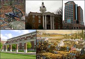
From top left, cannon at Stones River National Battlefield, Rutherford County Courthouse, City Center, MTSU's Paul W. Martin Sr. Honors Building, Battle of Stones River. | ||
| ||
| Nickname(s): "The 'Boro" | ||
| Motto: Creating a better quality of life. | ||
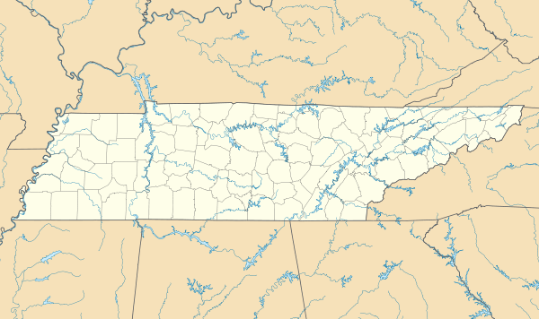 Murfreesboro, Tennessee Location in Rutherford County and the state of Tennessee. | ||
| Coordinates: 35°50′46″N 86°23′31″W / 35.84611°N 86.39194°W | ||
| Country | United States | |
| State | Tennessee | |
| County | Rutherford | |
| Settled | 1811 | |
| Incorporated | 1817 | |
| Government | ||
| • Type | Mayor–Council | |
| • Mayor | Shane McFarland (R)[1] | |
| • Vice mayor | Doug Young[2] | |
| Area | ||
| • City | 39.2 sq mi (101.5 km2) | |
| • Land | 39.0 sq mi (101.0 km2) | |
| • Water | 0.20 sq mi (0.5 km2) 0.54% | |
| Elevation | 619.0 ft (186 m) | |
| Population (2010)[3][4] | ||
| • City | 108,755 | |
| • Estimate (2014)[5] | 120,954 | |
| • Rank | US: 222th | |
| • Density | 2,800/sq mi (1,100/km2) | |
| • Urban | 133,228 (US: 241th) | |
| Time zone | CST (UTC-6) | |
| • Summer (DST) | CDT (UTC-5) | |
| ZIP codes | 37127-37133 | |
| Area code(s) | 615 | |
| FIPS code | 47-51560 | |
| GNIS feature ID | 1295105[6] | |
| Website | City of Murfreesboro | |
Murfreesboro is a city in and the county seat of Rutherford County, Tennessee.[7] The population was 108,755 according to the 2010 census, up from 68,816 residents certified in 2000. In 2014, census estimates showed a population of 120,954.[5] The city is the center of population of Tennessee[8] and is part of the Nashville metropolitan area, which includes thirteen counties and a population of 1,757,912 (2013). It is Tennessee's fastest growing major city and one of the fastest growing cities in the country.[9] Murfreesboro is also home to Middle Tennessee State University, the largest undergraduate university in the state of Tennessee, with an undergraduate population of 22,299 and 25,188 total students as of 2009.[10]
In 2006, Murfreesboro was ranked by Money as the 84th best place to live in the United States, out of 745 cities with a population over 50,000.[11][12]
History
In 1811, the Tennessee State Legislature established a county seat for Rutherford County. The town was first named "Cannonsburgh" in honor of Tennessee politician Newton Cannon, but was soon renamed "Murfreesboro" for Revolutionary War hero Colonel Hardy Murfree.[13] Author Mary Noailles Murfree was his great-granddaughter.
As Tennessee grew westward, the location of the state capital in Knoxville began to be inconvenient for the many settlers at a distance to the west. In 1818, Murfreesboro was designated as the capital of Tennessee. In 1826, it was replaced by Nashville as the state capital.[14]
Civil War
On December 31, 1862, the Battle of Stones River, also called the Battle of Murfreesboro, was fought near the city between the Union Army of the Cumberland and the Confederate Army of Tennessee. This was a major engagement of the American Civil War. Between December 31 and January 2, 1863, there were 23,515 casualties.[15] It was the bloodiest battle of the war based on percentage of casualties.
Following the Confederate retreat from the Battle of Perryville in central Kentucky, Confederate forces moved through East Tennessee and turned northwest to defend at Murfreesboro. General Bragg's veteran cavalry was successful in harassing General Rosecrans' troop movements and in capturing and destroying supply trains, but could not completely stop the supplies and reinforcements from reaching Rosecrans. Despite the large number of casualties, the battle was tactically inconclusive. It is considered a Union victory. At the end of the battle, Confederate General Braxton Bragg retreated 36 miles (58 km) south to Tullahoma. General Rosecrans did not pursue until he had a secure logistical posture six months later in June 1863. The battle was strategically significant since it provided the Union with the basis for further movement to Chattanooga and Atlanta, which would eventually result in the Union splitting the Eastern and Western theaters by Sherman's March to the Sea. Stones River National Battlefield is a national historical site.
General Rosecrans' movement to the south was dependent on a secure source of provisions. Murfreesboro was destined to become a supply depot for the Union Army. Soon after the battle ended in January 1863, Brigadier General James St. Clair Morton, Chief Engineer of the Army of the Cumberland, was charged with constructing Fortress Rosecrans approximately 2 miles (3.2 km) northwest of the town. The fortifications comprised more than 225 acres (0.91 km2) and were the largest built during the war. Immense quantities of supplies were stored and maintained in the fortress. The fortress consisted of eight lunettes, four redoubts and connecting fortifications. Both the Nashville and Chattanooga Railroad and the West Fork of the Stones River ran through the fortress. Two roads provided additional transportation capabilities.
The interior of the fortress was a huge logistical resource center including sawmills, warehouses, quartermaster maintenance depots, ammunition magazines, and living quarters for the 2,000 troops who handled the supply operations and defended the fortress. After the fortress was rushed to completion in June, Rosecrans moved south leaving Brigadier General Horatio P. Van Cleve in command.[16] The fortress was never assaulted by Confederate forces, in part, because the Union held the town hostage by keeping cannon aimed at the courthouse. Significant portions of the earthworks still exist and have been incorporated into the battlefield site.
Post-Civil War
Murfreesboro had begun as a mainly agricultural community, but by 1853 the area was home to several colleges and academies, earning it the nickname "Athens of Tennessee". Despite the trauma of the Civil War, by the early 1900s its growth began to regain momentum, in contrast to large areas of the South.
In 1911, the state created Middle Tennessee State Normal School, a two-year school for training teachers. There was a subsequent merger with the Tennessee College for Women. In 1925 the school was expanded to a four-year institution. During and following World War II, it grew and developed, attaining university status in 1965 as Middle Tennessee State University.[17] MTSU now has the highest undergraduate enrollment in the state, including several hundred international students.
World War II resulted in Murfreesboro diversifying into industry, manufacturing, and education. Since the end of World War II, growth has been steady, giving rise to a stable economy.
Murfreesboro has enjoyed substantial residential and commercial growth, with its population increasing 123.9% between 1990 and 2010, from 44,922 to 100,575.[18] The city has been a destination for many immigrants leaving areas affected by warfare; since 1990 numerous Somalis and Kurds from Iraq have settled here. The city has also become more cosmopolitan by attracting more numerous international students to the university.
Murfreesboro hosted its first pride parade in 2016.[19]
Government
The city council has six members, all elected at-large for four-year terms, on staggered schedules with elections every two years. The mayor is elected at large. City council members have responsibilities for various city departments.
Geography
Murfreesboro is located at 35°50′46″N 86°23′31″W / 35.846143°N 86.392078°W.[20]
According to the United States Census Bureau, the city has a total area of 39.2 square miles (102 km2). 39.0 square miles (101 km2) of it is land and 0.2 square miles (0.52 km2) of it (0.54%) is water. However, as of 2013 the city reports its total area as 55.94 square miles (144.9 km2).[21]:23
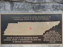
Murfreesboro is the geographic center of the state of Tennessee. A stone monument marks the official site on Old Lascassas Pike, about 0.5 miles (0.80 km) north of MTSU.
The West Fork of the Stones River flows through Murfreesboro. A walking trail, the Greenway, parallels the river for several miles. A smaller waterway, Lytle Creek, flows through downtown including historic "Cannonsburgh Village". Parts of the 19-mile (31 km) long creek suffer from pollution due to the urban environment and its use as a storm-water runoff.[22]
Murfreesboro is home to a number of natural and man-made lakes plus several small wetlands including Todd's Lake and the Murfree Spring wetland area.[23][24]
Transportation
Murfreesboro is served by Nashville International Airport (IATA code BNA), Smyrna Airport (MQY) and Murfreesboro Municipal Airport (MBT). The city also benefits from several highways running through the city, including Interstates 24 and 840; U.S. Routes 41, 70S, and 231; and State Routes 1, 2, 10, 96, 99, and 268. Industry also has access to North-South rail service with the rail line from Nashville to Chattanooga.
Public transportation
Since April 2007, the City of Murfreesboro has established a new transportation system with nine small buses, each capable of holding sixteen people and including two spaces for wheelchairs. The system is called "Rover"; the buses are bright green with "Rover" and a cartoon dog painted on the side. Buses operate in six major corridors: Memorial Boulevard, NW Broad Street, Old Fort Parkway, South Church Street, Mercury Boulevard and Highland Avenue.
A one-way fare is US$1.00 for adults, US$0.50 for children 6–16 and seniors 65 and over, and free for children under 6. The system operates Monday to Friday, 6:00 a.m. to 6:00 p.m.[25][26]
Demographics
| Historical population | |||
|---|---|---|---|
| Census | Pop. | %± | |
| 1850 | 1,917 | — | |
| 1860 | 2,861 | 49.2% | |
| 1870 | 3,502 | 22.4% | |
| 1880 | 3,800 | 8.5% | |
| 1890 | 3,739 | −1.6% | |
| 1900 | 3,999 | 7.0% | |
| 1910 | 4,679 | 17.0% | |
| 1920 | 5,367 | 14.7% | |
| 1930 | 7,993 | 48.9% | |
| 1940 | 9,495 | 18.8% | |
| 1950 | 13,052 | 37.5% | |
| 1960 | 18,991 | 45.5% | |
| 1970 | 26,360 | 38.8% | |
| 1980 | 32,845 | 24.6% | |
| 1990 | 44,922 | 36.8% | |
| 2000 | 68,816 | 53.2% | |
| 2010 | 108,755 | 58.0% | |
| Est. 2015 | 126,118 | [27] | 16.0% |
| Sources: | |||
As of the 2010 census, there were 108,755 people residing in the city. The racial makeup of the city was 75.62% White, 15.18% Black / African American, 0.35% Native American, 3.36% Asian, 0.04% Pacific Islander, 2.79% from other races, and 2.65% from two or more races. Hispanic or Latino of any race were 5.93% of the population.
In the 2000 Census, There were 26,511 households out of which 30.7% had children under the age of 18 living with them, 43.8% were married couples living together, 11.9% had a female householder with no husband present, and 40.6% were non-families. 28.3% of all households were made up of individuals and 7.0% had someone living alone who was 65 years of age or older. The average household size was 2.42 and the average family size was 3.02.
In the city, the population was spread out with 22.7% under the age of 18, 20.5% from 18 to 24, 30.8% from 25 to 44, 17.3% from 45 to 64, and 8.8% who were 65 years of age or older. The median age was 29 years. For every 100 females there were 98.7 males. For every 100 females age 18 and over, there were 97.2 males.
The median income for a household in the city was $39,705, and the median income for a family was $52,654. Males had a median income of $36,078 versus $26,531 for females. The per capita income for the city was $20,219. About 8.2% of families and 14.1% of the population were below the poverty line, including 12.0% of those under the age of 18 and 11.1% of those 65 and older.
Special census estimates in 2005 indicated 81,393 residents, and in 2006 the U.S. Census Bureau's American Community Survey estimated a population of 92,559, with 35,842 households and 20,979 families in the city.[29] Murfreesboro's 2008 special census reported that the population had reached 100,575,[29] while preliminary information from the 2010 U.S. Census indicates a population of 108,755.
Education
Education within the city is overseen by Murfreesboro City Schools (MCS). MCS focuses on prekindergarten through sixth grade learning.[30] The city has 12 schools serving 7,200 students between grades pre-K through 6th.[21]:27 A 13th school, named Overall Creek Elementary is scheduled to be completed by 2014.[31] More than 68% of licensed employees have a master's degree or higher.[21]:27
High schools are overseen by Rutherford County Schools, which has 42 schools and a student population of nearly 40,000.[32]:3
The Japanese Supplementary School in Middle Tennessee (JSMT, 中部テネシー日本語補習校 Chūbu Teneshī Nihongo Hoshūkō), a weekend Japanese education program, holds its classes at Peck Hall of the Middle Tennessee State University, while its school offices are in Jefferson Square.[33]
Parks
Cannonsburgh Village is a reproduction of what a working pioneer village would have looked like from the period of the 1830s to the 1930s. Visitors can view the grist mill, school house, doctor's office, Leeman House, Caboose, Wedding Chapel, and other points of interest. It is also home to the World's Largest Cedar Bucket.[34][35]
Old Fort Park is a 50-acre (200,000 m2) park which includes baseball fields, tennis courts, children's playground, an 18-hole championship golf course, picnic shelters and bike trail.[36]
Barfield Crescent Park is a 430-acre (1,700,000 m2) facility with eight baseball fields, 7 miles (11 km) of biking/running trails, an 18-hole championship disc golf course, and ten picnic shelters.[37]
Murfreesboro Greenway System is a system of greenways with 12 miles (19 km) of paved paths and 11 trail heads.[38] In 2013, the city council approved a controversial 25-year "master plan" to extend the system by adding 173 miles worth of new greenways, bikeways and blueways at an estimated cost of $104.8 million.[39]
Culture
Music
Murfreesboro hosts several music-oriented events annually, such as the Main Street Jazzfest presented by MTSU's School of Music and the Main Street Association each May.[34][40] For over 30 years, Uncle Dave Macon Days has celebrated the musical tradition of Uncle Dave Macon. This annual July event includes national competitions for old-time music and dancing.[34][41]
Because of MTSU's large music program, the city has fostered a number of bands and songwriters, including: The Tony Danza Tapdance Extravaganza, A Plea for Purging, Self, Fluid Ounces, The Katies, Count Bass D, Destroy Destroy Destroy and The Features.
Arts
The Murfreesboro Center for the Arts, close to the Square, entertains with a variety of exhibits, theatre arts, concerts, dances, and magic shows.[34] Murfreesboro Little Theatre has provided the community with popular and alternative forms of theatre arts since 1962.[42]
Murfreesboro's International FolkFest began in 1982 and is held annually during the second week in June. Groups from countries spanning the globe participate in the festival, performing traditional songs and dances while attired in regional apparel.[43]
The MTSU Student Film Festival showcases student-submitted films annually during the second week in April.[44][45]
Other organizations include Youth Empowerment through Arts and Humanities[46] and the Murfreesboro Youth Orchestra.[47]
Museums
The Discovery Center at Murfree Spring is a nature center and interactive museum focusing on children and families. The facility includes 20 acres (8 ha) of wetlands with a variety of animals.[48]
Bradley Academy Museum contains collectibles and exhibits of the first school in Rutherford County. This school was later renovated to become the only African American school in Murfreesboro, which closed in 1955.[34][49]
The Stones River National Battlefield is a national park which memorializes the Battle of Stones River, which took place during the American Civil War during December 31, 1862, to January 3, 1863. The grounds include a museum, a national cemetery, monuments, and the remains of a large earthen fortification called Fortress Rosecrans.[34]
Oaklands Historic House Museum is a 19th-century mansion which became involved in the Civil War. It was occupied as a residence until the 1950s, after which it was purchased by the City of Murfreesboro and renovated into a museum by the Oaklands Association.[34][50]
Shopping
There are two main malls located within the city limits. Stones River Mall is a traditional enclosed mall, featuring stores and restaurants such as Forever 21, Aéropostale, Journey's, Hot Topic, Agaci, Dillard's, Buckle, Books-A-Million, Olive Garden, and T.G.I. Friday's.
The Avenue Murfreesboro is an outdoor lifestyle center with such shops as American Eagle, Hollister, Best Buy, Belk, Petco, Dick's Sporting Goods, Express, Mimi's Cafe, Romano's Macaroni Grill, and LongHorn Steakhouse.
The Historic Downtown Murfreesboro district also offers a wide variety of shopping and dining experiences that encircle the pre-Civil War Courthouse.[51]
Media
Murfreesboro is serviced by the following media outlets:
Newspapers:
- The Daily News Journal
- The Murfreesboro Post
- The Murfreesboro Pulse
- Sidelines – MTSU student newspaper
Radio:
- WGNS – Talk radio
- WMOT – MTSU public radio station
- WMTS-FM – MTSU free-form student-run station
- WRHW-LP - 3ABN Radio Christian
TV:
- City TV Murfreesboro, Channel 3 – Government-access television channel
- MT10, Channel 10 – MTSU student-run educational-access television channel
- WETV-LP, Channel 11 – Provides audio/video simulcast of talk radio station WGNS
2009 tornado
Murfreesboro has been in the path of destructive tornados several times. On April 10, 2009, at approximately 12:30 p.m. CDT, an EF4 tornado struck the western and northern fringes of the city of Murfreesboro. As a result, two people were killed and 41 others injured. 845 homes were affected: 117 were totally destroyed; 292 had major damage; 175 had minor damage and 255 others were affected to some degree. The tornado, which the National Weather Service indicates was on the ground for about a half-hour, is estimated to have caused in excess of US$40 million in damages.[52]
Mosque controversy
Beginning in 2010, the Islamic Center of Murfreesboro faced protests related to its plan to build a new 12,000-square-foot (1,100 m2) mosque. The county planning council had approved the project, but opposition grew in the aftermath, affected by this being a year of elections. Signs on the building site were vandalized, with the first saying "not welcome" sprayed across it and the second being cut in two.[53] Construction equipment was also torched by arsonists.[54]
In August 2011, a Rutherford County judge upheld his previous decision allowing the mosque to be built, noting the US constitutional right to religious freedom and the ICM's observance of needed process.[55] The Center has a permanent membership of around 250 families and a few hundred students from the university.[56] The case ultimately attracted national media attention as an issue of religious freedom.
Points of interest
- Discovery Center at Murfree Spring
- Geographic center of Tennessee
- Middle Tennessee State University
- Oaklands Historic House Museum
- Stones River Greenway Arboretum
- Stones River National Battlefield
- Cannonsburgh Village
Murfreesboro is the home of a Consolidated Mail Outpatient Pharmacy (CMOP). It is part of an initiative by the Department of Veterans Affairs to provide mail order prescriptions to veterans using computerization at strategic locations throughout the United States. It is located on the campus of the Alvin C. York Veterans Hospital.
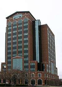
The City Center building (also known as the Swanson Building) is the tallest building in Murfreesboro. Located in the downtown area it was built by Joseph Swanson in 1989.[57] It has 15 floors, including a large penthouse, and stands 211 feet (64 m) tall.[58] As a commercial building its tenants include Bank of America and is the headquarters for the National Healthcare Corporation (NHC).
Economy
Top employers
According to Murfreesboro's 2014 Comprehensive Annual Financial Report,[59] the top employers in Rutherford County are:
| # | Employer | # of Employees |
|---|---|---|
| 1 | Nissan | 7,500 |
| 2 | Rutherford County government and schools | 6,073 |
| 3 | Middle Tennessee State University | 2,205 |
| 4 | National Healthcare | 2,071 |
| 5 | City of Murfreesboro government and schools | 1,912 |
| 6 | State Farm Insurance | 1,662 |
| 7 | Ingram Content Group | 1,500 |
| 8 | Alvin C. York Veterans Administration Medical Center | 1,461 |
| 9 | Asurion | 1,250 |
| 10 | Amazon.com | 1,200 |
Notable people
- Jerry Anderson (1953–1989), football player
- Toni Baldwin (born 1995), singer and songwriter
- Rankin Barbee (1874–1958), journalist and author
- Ronnie Barrett (born 1954), firearms manufacturer
- James M. Buchanan (1919–2013), economist
- Reno Collier, stand-up comedian
- Colton Dixon (born 1991), singer
- Will Allen Dromgoole, (1860–1934), author and poet
- Harold Earthman (1900–1987), politician
- Jeff Givens (died 2013), horse trainer
- Bart Gordon (born 1949), politician and lawyer
- Susan Harney (born 1946), actress
- Joe Black Hayes (1915–2013), football player
- Yolanda Hughes-Heying (born 1963), professional female bodybuilder
- Robert James (born 1947), football player
- Marshall Keeble (1878–1962), African American preacher
- Andrew Nelson Lytle (1902–1995), novelist, dramatist, essayist and professor
- Jean MacArthur (1898–2000), wife of U.S. Army General of the Army Douglas MacArthur
- Matt Mahaffey (born 1973), record producer and recording engineer
- Philip D. McCulloch, Jr. (1851–1928), politician
- Ridley McLean (1872–1933), United States Navy Rear Admiral
- Joseph B. Palmer (1925–1990), lawyer, legislator, and soldier
- Sarah Childress Polk (1803–1891), First Lady of the United States
- Patrick Porter, singer-songwriter
- David Price (born 1985), Major League Baseball pitcher
- Grantland Rice (1880–1954), iconic sportswriter, journalist and poet
- Mary Scales, 1928–2013, professor and civic leader
- Robert W. Scales (1926–2000), Vice-Mayor of Murfreesboro
- Margaret Rhea Seddon (born 1947), NASA astronaut
- Chuck Taylor (born 1942), Major League Baseball relief pitcher
- Chris Young (born 1985), country music artist
- Red State Update (a.k.a Jonathan Shockley and Travis Harmon), well-known comic YouTube stars
Notable bands
- Destroy Destroy Destroy, American heavy metal band
- De Novo Dahl, Indie rock band
- Feable Weiner, American power pop band
- Fluid Ounces, American power pop band
- Self, American alternative pop/rock band
- The Katies, American power pop band
- The Plain, American rock band
- The Tony Danza Tapdance Extravaganza, American mathcore band
- Velcro Stars, Indie pop band
See also
- Blackman, Tennessee
- Boxwood (Murfreesboro, Tennessee)
- Barrett Firearms Manufacturing
- First Presbyterian Church (Murfreesboro, Tennessee)
- Murfreesboro Musicians
- Murphy Center
- Evergreen Cemetery
References
- ↑ Broden, Scott (April 30, 2014). "Mayor McFarland to take oath of office Thursday". The Daily News Journal. Retrieved May 2, 2014.
- ↑ Broden, Scott (May 1, 2014). "Council appoints Doug Young as vice mayor". The Daily News Journal. Retrieved May 2, 2014.
- ↑ "American FactFinder". United States Census Bureau. Retrieved November 6, 2014.
- ↑ "Population of Urban Clusters and Urbanized Areas, by State" (PDF). EPA.gov.
- 1 2 "Annual Estimates of the Resident Population for Incorporated Places: April 1, 2010 to July 1, 2014". Retrieved June 4, 2015.
- ↑ "US Board on Geographic Names". United States Geological Survey. October 25, 2007. Retrieved January 31, 2008.
- ↑ "Find a County". National Association of Counties. Retrieved June 7, 2011.
- ↑ "Population and Population Centers by State: 2000". Census.gov. Retrieved January 12, 2007.
- ↑ Solomon, Christopher (2010). "America's Fastest-Growing Cities". MSN Real Estate. Retrieved July 14, 2012.
- ↑ "Middle Tennessee State University: Fall 2009 Enrollment". Tennessee Board of Regents. March 18, 2010. Archived from the original (PDF) on October 7, 2010.
- ↑ "Best places to live 2006: Murfreesboro, TN snapshot". CNN.com. 2006. Retrieved March 21, 2008.
- ↑ "Murfreesboro a 'Best Place' to live". Nashville Business Journal. July 17, 2006. Retrieved July 23, 2007.
- ↑ Gannett, Henry (1905). The Origin of Certain Place Names in the United States. Geological Survey Bulletin, no. 258 (2nd ed.). Washington, D.C.: Government Printing Office. p. 218. OCLC 1156805.
- ↑ "History of Murfreesboro, TN". MurfreesboroTN.gov. Archived from the original on April 29, 2007. Retrieved May 22, 2007.
- ↑ "Battle Summary: Stones River". US National Park Service. Retrieved December 11, 2013.
- ↑ "TN Encyclopedia: FORTRESS ROSECRANS". Retrieved November 19, 2010.
- ↑ "Facts – Middle Tennessee State University". Retrieved November 19, 2010.
- ↑
- ↑ De Gennaro, Nancy (August 28, 2016). "Inaugural Murfreesboro Pride festival draws hundreds". The Daily News Journal. Retrieved August 29, 2016.
- ↑ "US Gazetteer files: 2010, 2000, and 1990". United States Census Bureau. February 12, 2011. Retrieved April 23, 2011.
- 1 2 3 "2013–14 Budget". City of Murfreesboro. 2013. Retrieved August 16, 2013.
- ↑ "Lytle Creek". MurfreesboroTN.gov. November 3, 2009. Retrieved September 8, 2011.
- ↑ "Understanding Town Creek". MurfreesboroTN.gov. 2008. Retrieved November 9, 2012.
- ↑ "Town Creek, Murfreesboro Tennessee". EPA.gov. Retrieved November 9, 2012.
- ↑ "'Rover' bus service set to begin in early April". MurfreesboroTN.gov. Archived from the original on May 2, 2007. Retrieved March 22, 2007.
- ↑ Hutchens, Turner (January 5, 2007). "Work begins on Rover bus fleet". Daily News Journal.
- ↑ "Annual Estimates of the Resident Population for Incorporated Places: April 1, 2010 to July 1, 2015". Retrieved July 2, 2016.
- ↑ "Census of Population and Housing". United States Census Bureau. Retrieved November 6, 2014.
- 1 2 Hudgins, Melinda (July 1, 2009). "'Boro ranks 12th in U.S. for growth". Daily News Journal. Retrieved July 1, 2009.
- ↑ "Schools". Murfreesboro City Schools. Retrieved August 16, 2013.
- ↑ Amanda Haggard (August 13, 2013). "City board names school Overall Creek". Daily News Journal. Retrieved August 16, 2013.
- ↑ "2013 Fact Book". Rutherford County Schools. Retrieved August 16, 2013.
- ↑ "所在地・連絡先" (Archive). Japanese Supplementary School in Middle Tennessee. Retrieved on April 5, 2015. "[補習校] Middle Tennessee State University (MTSU) Peck Hall 住所:1301 East Main Street Murfreesboro, TN 37132" (PDF Map/Archive) and "住所:805 South Church Street Jefferson Square, Suite 8 Murfreesboro, TN 37130"
- 1 2 3 4 5 6 7 Littman, Margaret (2013). Tennessee. Moon Handbooks. Avalon Travel. pp. 271–272. ISBN 1612381502.
- ↑ "Cannonsburgh Village". City of Murfreesboro. Retrieved March 30, 2014.
- ↑ "Old Fort Park". City of Murfreesboro. Archived from the original on July 20, 2008.
- ↑ "Barfield Crescent Park". City of Murfreesboro. Retrieved March 30, 2014.
- ↑ "Murfreesboro Greenway system". City of Murfreesboro. Archived from the original on January 18, 2013.
- ↑ "Concerns and Enthusiasm Over Greenway Expansion Clash at City Council Meeting". WGNS. March 7, 2013. Retrieved March 30, 2014.
- ↑ "Main Street Murfreesboro releases lineup for JazzFest". Southern Manners. March 10, 2014. Retrieved March 26, 2014.
- ↑ "Uncle Dave Macon Days celebrates 36 years". Murfreesboro Post. June 26, 2013. Retrieved March 26, 2014.
- ↑ Willard, Michelle (July 25, 2013). "Murfreesboro Little Theatre wraps up 50th season". Murfreesboro Post. Retrieved March 26, 2014.
- ↑ Kemph, Marie (June 10, 2012). "International Folkfest celebrates diversity". Murfreesboro Post. Retrieved March 26, 2014.
- ↑ "14th Annual MTSU Student Film Festival". MTSU.edu. Retrieved March 26, 2014.
- ↑ "MTSU student film fest returns". Murfreesboro Post. February 16, 2011. Retrieved March 26, 2014.
- ↑ Paulson, Dave (December 15, 2009). "YEAH offers Murfreesboro youths empowerment through arts". The Tennessean. Music. Retrieved March 26, 2014.
- ↑ "Murfreesboro Youth Orchestra". Now Playing Nashville. Retrieved March 26, 2014.
- ↑ "Discovery Center adds Lifelong Learning classes". The Daily News Journal. February 21, 2014. Retrieved March 26, 2014.
- ↑ West, Mike (January 24, 2010). "Bradley Academy dates back to 1811". Murfreesboro Post. Retrieved March 30, 2014.
- ↑ "History of Oaklands Plantation". Oaklands Historic House Museum. Retrieved March 30, 2014.
- ↑ "Main Street Murfreesboro". DowntownMurfreesboro.com. Retrieved March 30, 2014.
- ↑ Davis, Doug (April 17, 2009). "Damage estimates hit $41.8M". The Daily News Journal. Retrieved April 17, 2009.
- ↑ Kauffman, Elizabeth (August 19, 2010). "In Murfreesboro, Tenn.: Church 'Yes,' Mosque 'No'". Time. Retrieved July 18, 2011.
- ↑ "Fire at Tenn. Mosque Building Site Ruled Arson". Associated Press via CBS News. August 30, 2010. Retrieved July 18, 2011.
- ↑ Broden, Scott (August 31, 2011). "Judge upholds ruling for Murfreesboro mosque". The Tennessean. Gannett Tennessee. Retrieved September 4, 2011.
- ↑ Blackburn, Bradley (June 18, 2010). "Plan for Mosque in Tennessee Town Draws Criticism from Residents". ABC News. ABC News. Retrieved September 7, 2011.
- ↑ "100 E Vine Street – City Center". Showcase.com. Archived from the original on April 15, 2011.
- ↑ "City Center". Emporis.com. Retrieved March 30, 2014.
- ↑ "Comprehensive Annual Financial Report – Fiscal Year June 30, 2014". City of Murfreesboro. January 27, 2015. p. 153. Retrieved August 22, 2015.
External links
| Wikimedia Commons has media related to Murfreesboro, Tennessee. |
- Murfreesboro city website
- Linebaugh Public Library System
- Daily News Journal (newspaper)
- Murfreesboro Post (newspaper)
- Murfreesboro, Tennessee is at coordinates 35°50′46″N 86°23′31″W / 35.846143°N 86.392078°WCoordinates: 35°50′46″N 86°23′31″W / 35.846143°N 86.392078°W
Municipalities and communities of Rutherford County, Tennessee, United States | ||
|---|---|---|
| Cities | ||
| Town | ||
| CDP | ||
| Unincorporated communities | ||
| Footnotes | ‡This populated place also has portions in an adjacent county or counties | |