McNairy County, Tennessee
| McNairy County, Tennessee | |
|---|---|
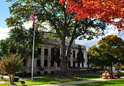 McNairy County Courthouse in Selmer | |
|
Location in the U.S. state of Tennessee | |
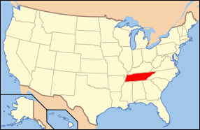 Tennessee's location in the U.S. | |
| Founded | October 8, 1823 |
| Named for | John McNairy[1] |
| Seat | Selmer |
| Largest town | Selmer |
| Area | |
| • Total | 564 sq mi (1,461 km2) |
| • Land | 563 sq mi (1,458 km2) |
| • Water | 0.8 sq mi (2 km2), 0.1% |
| Population | |
| • (2010) | 26,075 |
| • Density | 46/sq mi (18/km²) |
| Congressional district | 7th |
| Time zone | Central: UTC-6/-5 |
| Website |
www |
McNairy County is a county located in the U.S. state of Tennessee. As of the 2010 census, the population was 26,075.[2] Its county seat is Selmer.[3] McNairy County is located along Tennessee's border with the state of Mississippi.
Sheriff Buford Pusser, whose story was told in the Walking Tall series of movies, was the sheriff of McNairy County from 1964 to 1970.[4]
McNairy County is the location of the Coon Creek Science Center, a notable fossil site that preserves Late Cretaceous marine shells and vertebrate remains (such as mosasaurs).
History
McNairy County was formed in 1823 from parts of Hardin County, and was named for Judge John McNairy.[1]
County seat
Purdy was the county seat of McNairy County until 1890.[5] Since then, Selmer has been the county seat.
Sheriff Buford Pusser
Buford Pusser served as the sheriff of McNairy County from 1964 to 1970. The courthouse and jail in Selmer were his base of operations. He gained prominence for his fight against illegal distilleries, bootleggers, gambling establishments, and corruption in the county. His story has been made famous in the Walking Tall series of movies starring Joe Don Baker, Bo Svenson and Brian Dennehy, and in numerous documentaries and books.[4][6]
Newspapers
The oldest existing business in McNairy County is its newspaper, the Independent Appeal, which was founded in 1902. It is located in Selmer.
McNairy County News began publication in 2009. The MCN is located at 252 Mulberry Avenue in Selmer. The paper has an online presence at mcnairycountynews.com and a Facebook page, as well as a weekly printed publication each Thursday.
Geography
According to the U.S. Census Bureau, the county has a total area of 564 square miles (1,460 km2), of which 563 square miles (1,460 km2) is land and 0.8 square miles (2.1 km2) (0.1%) is water.[7]
The major highways U.S. Route 64 (east-west) and U.S. Route 45 (north-south) pass through McNairy County and intersect in Selmer. Between the late 1990s and mid 2010s, both highways were upgraded to four lane divided highways, giving the county quicker access to the surrounding areas. McNairy County's position on Route 64 places it on the historic Lee Highway, which stretches from New York to San Francisco.
State Highways 22 and 57 also pass through the county. SR 22 along the eastern portion intersecting with US 64 in Adamsville, and SR 57 through the southern portion intersecting with US 45 in Eastview.
Adjacent counties
- Chester County (north)
- Hardin County (east)
- Alcorn County, Mississippi (south)
- Hardeman County (west)
State protected areas
Demographics
| Historical population | |||
|---|---|---|---|
| Census | Pop. | %± | |
| 1830 | 5,697 | — | |
| 1840 | 9,385 | 64.7% | |
| 1850 | 12,864 | 37.1% | |
| 1860 | 14,732 | 14.5% | |
| 1870 | 12,726 | −13.6% | |
| 1880 | 17,271 | 35.7% | |
| 1890 | 15,510 | −10.2% | |
| 1900 | 17,760 | 14.5% | |
| 1910 | 16,536 | −6.9% | |
| 1920 | 18,350 | 11.0% | |
| 1930 | 19,901 | 8.5% | |
| 1940 | 20,424 | 2.6% | |
| 1950 | 20,390 | −0.2% | |
| 1960 | 18,085 | −11.3% | |
| 1970 | 18,369 | 1.6% | |
| 1980 | 22,525 | 22.6% | |
| 1990 | 22,422 | −0.5% | |
| 2000 | 24,653 | 10.0% | |
| 2010 | 26,075 | 5.8% | |
| Est. 2015 | 26,066 | [8] | 0.0% |
| U.S. Decennial Census[9] 1790-1960[10] 1900-1990[11] 1990-2000[12] 2010-2014[2] | |||

As of the census[14] of 2000, there were 24,653 people, 9,980 households, and 7,135 families residing in the county. The population density was 44 people per square mile (17/km²). There were 11,219 housing units at an average density of 20 per square mile (8/km²). The racial makeup of the county was 92.22% White, 6.23% Black or African American, 0.20% Native American, 0.13% Asian, 0.24% from other races, and 0.98% from two or more races. 0.93% of the population were Hispanic or Latino of any race.
There were 9,980 households out of which 29.90% had children under the age of 18 living with them, 58.00% were married couples living together, 9.90% had a female householder with no husband present, and 28.50% were non-families. 25.90% of all households were made up of individuals and 12.50% had someone living alone who was 65 years of age or older. The average household size was 2.42 and the average family size was 2.89.
In the county, the population was spread out with 23.60% under the age of 18, 8.10% from 18 to 24, 26.70% from 25 to 44, 25.60% from 45 to 64, and 15.90% who were 65 years of age or older. The median age was 39 years. For every 100 females there were 94.20 males. For every 100 females age 18 and over, there were 91.40 males.
The median income for a household in the county was $30,154, and the median income for a family was $36,045. Males had a median income of $30,028 versus $21,450 for females. The per capita income for the county was $16,385. About 11.80% of families and 15.90% of the population were below the poverty line, including 19.00% of those under age 18 and 20.80% of those age 65 or over.
Parks and attractions
McNairy County is the site of 5,000-acre (20 km2) Big Hill Pond State Park, which is forested with timberland and hardwood bottomland. The county is also the location of the Coon Creek Science Center,[15] a notable fossil site, located in Leapwood over the Coon Creek Formation, which preserves Late Cretaceous marine shells and vertebrate remains (such as mosasaurs) left there 70 million years ago.
McNairy County is home to one of the most successful rural arts organizations in the state, AiM (Arts in McNairy). AiM pushes for arts recognition in the county and surrounding area through theatre productions, exhibits of local artists, and the bi-annual Artisan Trail.
Communities

Cities
Towns
- Adamsville (partial)
- Bethel Springs
- Eastview
- Enville (partial)
- Guys
- Michie
- Milledgeville (partial)
- Selmer (county seat)
- Stantonville
Unincorporated communities
See also
References
- 1 2 Bill Wagoner, "McNairy County," Tennessee Encyclopedia of History and Culture. Retrieved: 11 March 2013
- 1 2 "State & County QuickFacts". United States Census Bureau. Retrieved December 6, 2013.
- ↑ "Find a County". National Association of Counties. Retrieved 2011-06-07.
- 1 2 Buford Pusser, the Man, his Career, and Tragedies, Buford Pusser Museum website. Retrieved: 23 October 2013.
- ↑ The Death Song of Purdy, by Nancy Wardlow Kennedy
- ↑ Janet Rail, "A Man Who 'Walked Tall' in McNairy County," SheriffBufordPusser.com. Accessed via Archive.org: 23 October 2013.
- ↑ "2010 Census Gazetteer Files". United States Census Bureau. August 22, 2012. Retrieved April 9, 2015.
- ↑ "County Totals Dataset: Population, Population Change and Estimated Components of Population Change: April 1, 2010 to July 1, 2015". Retrieved July 2, 2016.
- ↑ "U.S. Decennial Census". United States Census Bureau. Retrieved April 9, 2015.
- ↑ "Historical Census Browser". University of Virginia Library. Retrieved April 9, 2015.
- ↑ Forstall, Richard L., ed. (March 27, 1995). "Population of Counties by Decennial Census: 1900 to 1990". United States Census Bureau. Retrieved April 9, 2015.
- ↑ "Census 2000 PHC-T-4. Ranking Tables for Counties: 1990 and 2000" (PDF). United States Census Bureau. April 2, 2001. Retrieved April 9, 2015.
- ↑ Based on 2000 census data
- ↑ "American FactFinder". United States Census Bureau. Retrieved 2011-05-14.
- ↑ Coon Creek Science Center
- ↑ Rose Creek Village, Inc. website
External links
| Wikimedia Commons has media related to McNairy County, Tennessee. |
- Official site
- McNairy County Chamber of Commerce
- McNairy County at DMOZ
- McNairy County at TNGenWeb
- Arts in McNairy Homepage
- McNairy Central High School
- Reminiscences of the Early Settlement and Early Settlers of McNairy County, Tennessee
- Let’s Call It Finger: A History of North McNairy County and Finger, Tennessee and Its Surrounding Communities
- A History of Mount Carmel Cemetery and Meeting House, McNairy County, Tennessee
 |
Chester County | | ||
| Hardeman County | |
Hardin County | ||
| ||||
| | ||||
| Alcorn County, Mississippi |
Municipalities and communities of McNairy County, Tennessee, United States | ||
|---|---|---|
| Cities | ||
| Towns | ||
| Unincorporated communities | ||
| Footnotes | ‡This populated place also has portions in an adjacent county or counties | |
Coordinates: 35°11′N 88°34′W / 35.18°N 88.56°W