Sequatchie County, Tennessee
| Sequatchie County, Tennessee | |
|---|---|
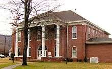 Sequatchie County Courthouse in Dunlap | |
|
Location in the U.S. state of Tennessee | |
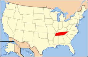 Tennessee's location in the U.S. | |
| Founded | December 9, 1857[1] |
| Named for | Cherokee chief[2] |
| Seat | Dunlap |
| Largest city | Dunlap |
| Area | |
| • Total | 266 sq mi (689 km2) |
| • Land | 266 sq mi (689 km2) |
| • Water | 0.2 sq mi (1 km2), 0.07% |
| Population | |
| • (2010) | 14,112 |
| • Density | 53/sq mi (20/km²) |
| Congressional district | 4th |
| Time zone | Central: UTC-6/-5 |
| Website |
sequatchiecounty-tn |
Sequatchie County is a county located in the U.S. state of Tennessee. As of the 2010 census, the population was 14,112.[3] Its county seat is Dunlap.[4]
Sequatchie County is part of the Chattanooga, TN–GA Metropolitan Statistical Area.
History
Sequatchie County was created in 1857 from a portion of Hamilton County.[1] It was named for the Sequatchie Valley, which in turn had been named for a Cherokee chief. The word sequachee in Cherokee means, "opossum" or "he grins or runs."[5] Settlers began arriving in what is now Sequatchie by the early 19th century, drawn to the area by the fertile land in the valley.[1]
At the outset of the Civil War, Sequatchie was divided over the issue of secession. On June 8, 1861, Sequatchie Countians voted in favor of Tennessee's Ordinance of Secession by a vote 153 to 100. [6] In October 1863, Confederate General Joseph Wheeler led a raid into Sequatchie, burning nearly a thousand wagons and capturing livestock.[1]
During the late 19th century, the Douglas Coal and Coke Company (later the Chattanooga Iron and Coal Corporation) conducted extensive mining activities in the Dunlap area. The company constructed 268 beehive ovens, now known as the Dunlap Coke Ovens, to convert coal into coke. The ovens are now the focus of a local park.[1]
Geography
According to the U.S. Census Bureau, the county has a total area of 266 square miles (690 km2), of which 266 square miles (690 km2) is land and 0.2 square miles (0.52 km2) (0.07%) is water.[7]
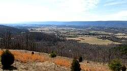
Sequatchie is one of three counties (along with Bledsoe and Marion) situated in the Sequatchie Valley, a long, narrow valley running northeast-to-southwest across the eastern portion of the Cumberland Plateau. The county is flanked by the Plateau's Walden Ridge escarpment on the east. The Sequatchie River, which spans the valley, passes through the county.
Two major highways, U.S. Route 127 and Tennessee State Route 111, intersect in Dunlap.
While the two other counties in the Sequatchie Valley, Bledsoe and Marion, are grouped with the East Tennessee grand division, Sequatchie is grouped with Middle Tennessee.[8]
Adjacent counties
- Van Buren County (north)
- Bledsoe County (northeast)
- Hamilton County (southeast)
- Marion County (southwest)
- Grundy County (west)
- Warren County (northwest)
State protected areas
- North Chickamauga Creek State Natural Area (part)
- Prentice Cooper State Forest (part)
- Savage Gulf State Natural Area (part)
- South Cumberland State Park (part)
Demographics
| Historical population | |||
|---|---|---|---|
| Census | Pop. | %± | |
| 1860 | 2,120 | — | |
| 1870 | 2,335 | 10.1% | |
| 1880 | 2,565 | 9.9% | |
| 1890 | 3,027 | 18.0% | |
| 1900 | 3,326 | 9.9% | |
| 1910 | 4,202 | 26.3% | |
| 1920 | 3,632 | −13.6% | |
| 1930 | 4,047 | 11.4% | |
| 1940 | 5,038 | 24.5% | |
| 1950 | 5,685 | 12.8% | |
| 1960 | 5,915 | 4.0% | |
| 1970 | 6,331 | 7.0% | |
| 1980 | 8,605 | 35.9% | |
| 1990 | 8,863 | 3.0% | |
| 2000 | 11,370 | 28.3% | |
| 2010 | 14,112 | 24.1% | |
| Est. 2015 | 14,811 | [9] | 5.0% |
| U.S. Decennial Census[10] 1790-1960[11] 1900-1990[12] 1990-2000[13] 2010-2014[3] | |||
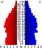
As of the census[15] of 2010, there were 14,112 people, 4,463 households, and 3,311 families residing in the county. The population density was 43 people per square mile (17/km²). There were 4,916 housing units at an average density of 18 per square mile (7/km²). The racial makeup of the county was 98.66% White, 0.19% Black or African American, 0.33% Native American, 0.13% Asian, 0.03% Pacific Islander, 0.17% from other races, and 0.48% from two or more races. 0.82% of the population were Hispanic or Latino of any race. Sequatchie County was mentioned as an "Extreme Whitopia" in Rich Benjamin's book, Searching for Whitopia.[16]
There were 4,463 households out of which 33.00% had children under the age of 18 living with them, 58.80% were married couples living together, 11.20% had a female householder with no husband present, and 25.80% were non-families. 22.40% of all households were made up of individuals and 8.80% had someone living alone who was 65 years of age or older. The average household size was 2.52 and the average family size was 2.92.
In the county, the population was spread out with 24.60% under the age of 18, 8.40% from 18 to 24, 30.00% from 25 to 44, 24.80% from 45 to 64, and 12.30% who were 65 years of age or older. The median age was 37 years. For every 100 females there were 98.30 males. For every 100 females age 18 and over, there were 95.80 males.
The median income for a household in the county was $30,959, and the median income for a family was $36,435. Males had a median income of $27,535 versus $20,422 for females. The per capita income for the county was $16,468. About 13.50% of families and 16.50% of the population were below the poverty line, including 21.50% of those under age 18 and 20.30% of those age 65 or over.
Education
Sequatchie County has a consolidated school system which is located in Dunlap. The system operates with a Superintendent and an elected School Board.
The Sequatchie County school system has three schools:
- Griffith Elementary School (Grades: K-4th)
- Sequatchie County Middle School (Grades: 5th-8th)
- Sequatchie County High School (Grades: 9th-12th)
Recreation
Sequatchie County is known as "The Hang Gliding Capital of the East", due in part to the presence of an active hang gliding association, the Tennessee Tree Toppers. This group maintains a hang gliding ramp at Henson's Gap, along the eastern wall of the Sequatchie Valley, where favorable flying conditions allow these unpowered aircraft to fly well into northwestern Georgia and northeastern Alabama after launch. The gap is the site of numerous hang gliding competitions, is a popular tourist attraction for aficionodos of the sport from all over the world.
Communities
City
- Dunlap (county seat)
Census-designated place
Unincorporated communities
- Brush Creek
- Cagle
- Lewis Chapel
Notable people
- James Standifer (1779–1837), U.S. congressman[1]
- William Stone (1791–1853), U.S. congressman
See also
References
- 1 2 3 4 5 6 Holly Anne Rine, "Sequatchie County," Tennessee Encyclopedia of History and Culture. Retrieved: 23 March 2013.
- ↑ Larry Miller, Tennessee Place Names (Indiana University Press, 2001), p. 239.
- 1 2 "State & County QuickFacts". United States Census Bureau. Retrieved December 7, 2013.
- ↑ "Find a County". National Association of Counties. Retrieved 2011-06-07.
- ↑ "Sequatchie Valley Called a 'Magnet' for Visitors," Chattanooga Times Free Press, 18 September 2011. Retrieved: 5 November 2013.
- ↑ Oliver Perry Temple, East Tennessee and the Civil War (R. Clarke Company, 1899), p. 199.
- ↑ "2010 Census Gazetteer Files". United States Census Bureau. August 22, 2012. Retrieved April 14, 2015.
- ↑ TNGenWeb Project, Three Grand Divisions of Tennessee. 1999. Retrieved: 5 November 2013.
- ↑ "County Totals Dataset: Population, Population Change and Estimated Components of Population Change: April 1, 2010 to July 1, 2015". Retrieved July 2, 2016.
- ↑ "U.S. Decennial Census". United States Census Bureau. Retrieved April 14, 2015.
- ↑ "Historical Census Browser". University of Virginia Library. Retrieved April 14, 2015.
- ↑ Forstall, Richard L., ed. (March 27, 1995). "Population of Counties by Decennial Census: 1900 to 1990". United States Census Bureau. Retrieved April 14, 2015.
- ↑ "Census 2000 PHC-T-4. Ranking Tables for Counties: 1990 and 2000" (PDF). United States Census Bureau. April 2, 2001. Retrieved April 14, 2015.
- ↑ Based on 2000 census data
- ↑ "American FactFinder". United States Census Bureau. Retrieved 2011-05-14.
- ↑ "Searching for Whitopia". Richbenjamin.com. Retrieved 23 March 2013.
External links
| Wikimedia Commons has media related to Sequatchie County, Tennessee. |
- Official site
- Sequatchie County Chamber of Commerce
- Sequatchie County Schools
- Sequatchie County, TNGenWeb - free genealogy resources for the county
- Sequatchie County at DMOZ
 |
Warren County | Van Buren County | Bledsoe County | |
| Grundy County | |
|||
| ||||
| | ||||
| Marion County | Hamilton County |
Municipalities and communities of Sequatchie County, Tennessee, United States | ||
|---|---|---|
| City | ||
| CDP | ||
| Unincorporated community | ||
Coordinates: 35°22′N 85°25′W / 35.37°N 85.41°W