Cap Blanc rock shelter
The abri de Cap Blanc is a prehistoric limestone rock shelter with Magdalenian animal sculptures. It is in the Marquay commune on the right bank of the Beune River, a few kilometers west of Eyzies-de-Tayac, in Dordogne.
History

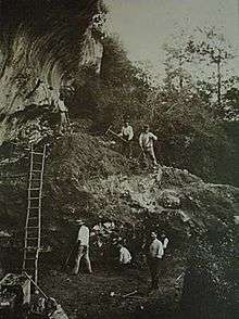
The site was discovered in 1908 by Raymond Peyrille under the supervision of Jean-Gaston Lalanne. Peyrille carried out its first rudimentary excavation was in 1909 while Lalanne was working at the nearby site of Laussel. During this excavation what has been described as "perhaps the most dramatic and impressive example of Upper Palaeolithic haut-relief carving" was found.[1]
Following the discovery of the frieze work was undertaken in 1911 to build a protective wall around the shelter. This included lowering the shelter floor and during this a workman hit a skull with a pickaxe, breaking it. A relatively complete skeleton was uncovered and Denis Peyrony and Louis Capitan were brought in to examine it.[2][3]
Frieze
The frieze depicts a number of animals, some in haut-relief, dating back 15 000 years. These include ten horses (one measuring 2.20 m long), at least three bison, ibex and several incomplete figures.
The sculpted frieze occupies 13 of the 16 meters of the shelter. Some of the carving is as much as 30 cm deep. Red ochre covers much of the frieze and some of the area around it but is now difficult to see. Among other flint tools probably used to create the frieze were found Magdalenian burins and scrapers.[4]
Magadalenian Girl

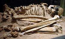
The skeleton known as Magdalenian Girl (or sometimes Magdalenian Woman) is that of an early modern human dating from 13,000 to 11,000 BCE during the Magdalenian period. It is the most complete Upper Paleolithic skeleton in Northern Europe. When Magdalenian Girl was acquired in 1926 for the Field Museum in Chicago, Illinois by Henry Field, then curator of Physical Anthropology, it was hailed as one of the most significant acquisitions the museum ever made. On the first day the precious specimen was exhibited, tens of thousands of visitors flocked to the museum to see it.
The skeleton is thought to have been likely buried deliberately. Paul Pettitt noted that "Large stone blocks were found over her head and feet, although no cultural irems were recovered with the skeleton".[5]
Preservation and visits
The site was classified as a French historical monument in 1910,[6] and registered as a World Heritage Site by Unesco in 1979 as part of the Prehistoric Sites and Decorated Caves of the Vézère Valley World Heritage Site. It was acquired by the French government on 14 April 2006.[7]
Guided tours take place during the year and there is an on-site museum which includes a replica of Magdalenian Girl.
See also
- Art of the Upper Paleolithic
- Cave of Altamira
- Cave painting
- Lascaux
- List of archaeological sites by country
- List of caves
- List of Stone Age art
- Prehistoric art
References
- ↑ Hansen, Charles D.; Johnson, Chris R. (2004). Visualization Handbook. Academic Press. p. 807. ISBN 978-0123875822. Retrieved 23 August 2016.
- ↑ Brown, J. P.; Martin, Robert D. (2014). "Restoration by other Means: CT Scanning and 3D Computer Modeling for the re-Restoration of a Previously Restored Skull from the Magdalenian Era" (PDF). Objects Specialty Group Postprints. The American Institute for Conservation of Historic & Artistic Works. 21: 81–101. ISSN 2169-1290. Retrieved 23 August 2016.
- ↑ Louis Capitan and Denis Peyrony , " Three new fossil skeletons ," Anthropological Review , n o 22,1912, P. 439-442
- ↑ Bahn, Paul G.; Vertut, Jean (1997). Journey Through the Ice Age. University of California Press. p. 112. ISBN 9780520229006. Retrieved 23 August 2016.
- ↑ Pettitt, Paul (2010). The Palaeolithic Origins of Human Burial (New edition 2010 ed.). Routledge. p. 238. ISBN 978-0415354905.
- ↑ " Notice n o PA00082632 " , basis Merimee, French Ministry of Culture
- ↑ "Prehistoric Sites and Decorated Caves of the Vézère Valley". UNESCO. Retrieved 15 February 2012.
External links
- (French) Visite virtuelle de l'abri de Cap Blanc
- (French) Présentation de l'Abri de Cap Blanc sur le site du Pôle International de la Préhistoire* (French) Site officiel de l'office de tourisme de la Vallée Vézère
Coordinates: 44°56′44″N 1°05′49″E / 44.9456°N 1.0969°E