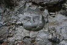
Lene Hara cave


The Lena Hara cave is the main cave of a system of solutional caves in the Lautém District at the eastern tip of East Timor (Timor-Leste), close to the village of Tutuala. Others are Ile Kére Kére and Jerimalai. It has provided evidence that Timor has been occupied by humans for 30-35,000 years[1] and thus is evidence of the colonisation of humans making the water crossing of Wallacea between the Pleistocene continents of Sunda and Sahul.
The cave was discovered to science in the early 1960s and first investigated in 1963 by Portuguese anthropologist, Antonio de Almeida when Timor Leste was under Portuguese rule.[1] Radiocarbon dating of the cave taken from digs beside those investigated by Almeida, by a team led by Sue O'Connor from the Australian National University, shows deposition of shells (trochus and strombus) by transitory inhabitants beginning 35,000 years BP.[1]
O'Connor et al pointed out that the earliest occupation of Australia is dated to around 55,000 BP, so it is likely that the deposits dated at 35,000 years represent another wave of human advance.[1]
O'Connor has also reported[2] finding in Lena Hara Holocene fish hooks made from shell, and shell beads.[3]
In May 2009, carved faces were found high in the cave, and have since been dated to 10,000 years. This was reported in the journal Antiquity of February 2011.[4] Paintings in Ile Kére Kére are believed to be 2,000 to 6,000 years old.
References
- 1 2 3 4 Excavation at Lene Hara Cave establishes occupation in East Timor at least 30,000-35,000 years, Sue O'Connor, Matthew Spriggs, Peter Veth, Antiquity, March 2002; 76, 291; accessed 11 February 2011
- ↑ Early Holocene shell fish hooks from Lene Hara Cave, East Timor, S O'Connor, 2005, Antiquity (journal), accessed 12 February 2011
- ↑ Direct dating of shell beads from Lene Hara Cave, East Timor, University of Queensland, 2009, accessed 12 February 2011
- ↑ Scientists find 10,000-year-old stone carvings, ABC News Online, 11 February 2011
Coordinates: 8°23′32″S 127°17′25″E / 8.39222°S 127.29028°E