Center Township, Carroll County, Ohio
| Center Township, Carroll County, Ohio | |
|---|---|
| Township | |
|
Community Park along State Route 39 in Center Township | |
 Location of Center Township in Carroll County | |
| Coordinates: 40°34′42″N 81°4′51″W / 40.57833°N 81.08083°WCoordinates: 40°34′42″N 81°4′51″W / 40.57833°N 81.08083°W | |
| Country | United States |
| State | Ohio |
| County | Carroll |
| Area | |
| • Total | 14.8 sq mi (38.4 km2) |
| • Land | 14.8 sq mi (38.4 km2) |
| • Water | 0.0 sq mi (0.0 km2) |
| Elevation[1] | 1,145 ft (349 m) |
| Population (2010) | |
| • Total | 4,664 |
| • Density | 315/sq mi (121.5/km2) |
| Time zone | Eastern (EST) (UTC-5) |
| • Summer (DST) | EDT (UTC-4) |
| FIPS code | 39-12896[2] |
| GNIS feature ID | 1085826[1] |

Center Township is one of the fourteen townships of Carroll County, Ohio, United States. As of the 2010 census there were 4,664 people living in the township, 1,423 of whom lived in the unincorporated portions of the township.[3]
Geography
Located at the center of the county, it borders the following townships:
- Washington Township - northeast
- Lee Township - southeast
- Union Township - southwest
- Harrison Township - northwest
The village of Carrollton, the county seat of Carroll County, is located in central Center Township.
Several state highways pass through the township, converging in Carrollton. Ohio State Route 9 leads northeast 28 miles (45 km) to Salem and south 30 miles (48 km) to Cadiz. Ohio State Route 39 crosses OH 9 in Carrollton and leads east 32 miles (51 km) to East Liverpool and west 25 miles (40 km) to New Philadelphia. Ohio State Route 43 leads northwest 26 miles (42 km) to Canton and southeast 34 miles (55 km) to Steubenville, and Ohio State Route 332 leads south 14 miles (23 km) to Scio.
Name and history
It is one of nine Center Townships statewide.[4]
Center Township was not organized as a separate civil township until several years after the organization of Carroll County in March 1836, when the county commissioners had presented them a petition asking for the erection of a separate township to be called "Centre", being composed of parts of Harrison and Washington townships.[5]
Government
| Historical population | |||
|---|---|---|---|
| Census | Pop. | %± | |
| 1840 | 1,139 | — | |
| 1850 | 1,199 | 5.3% | |
| 1860 | 1,204 | 0.4% | |
| 1870 | 1,227 | 1.9% | |
| 1880 | 1,590 | 29.6% | |
| 1890 | 1,605 | 0.9% | |
| 1900 | 1,704 | 6.2% | |
| 1910 | 2,149 | 26.1% | |
| 1920 | 2,653 | 23.5% | |
| 1930 | 2,884 | 8.7% | |
| 1940 | 3,245 | 12.5% | |
| 1950 | 3,450 | 6.3% | |
| 1960 | 3,893 | 12.8% | |
| 1970 | 4,311 | 10.7% | |
| 1980 | 4,526 | 5.0% | |
| 1990 | 4,434 | −2.0% | |
| 2000 | 4,412 | −0.5% | |
| 2010 | 4,664 | 5.7% | |
| [6] | |||
The township is governed by a three-member board of trustees, who are elected in November of odd-numbered years to a four-year term beginning on the following January 1. Two are elected in the year after the presidential election and one is elected in the year before it. There is also an elected township fiscal officer,[7] who serves a four-year term beginning on April 1 of the year after the election, which is held in November of the year before the presidential election. Vacancies in the fiscal officership or on the board of trustees are filled by the remaining trustees.
Education
Students attend the Carrollton Exempted Village School District.[8]
References
- 1 2 "US Board on Geographic Names". United States Geological Survey. 2007-10-25. Retrieved 2008-01-31.
- ↑ "American FactFinder". United States Census Bureau. Archived from the original on 2013-09-11. Retrieved 2008-01-31.
- ↑ "Geographic Identifiers: 2010 Demographic Profile Data (G001): Center township, Carroll County, Ohio". U.S. Census Bureau, American Factfinder. Retrieved January 7, 2015.
- ↑ "Detailed map of Ohio" (PDF). United States Census Bureau. 2000. Retrieved 2007-02-16.
- ↑ Eckley, H.J.; Perry, W.T. (1921). History of Carroll and Harrison Counties. The Lewis Publishing Co. pp. 121, 185.
- ↑ census data: 1840, 1880 : Howe, Henry (1907). Historical Collections of Ohio, The Ohio Centennial Edition. The State of Ohio. p. 359. , 1850 : 1850 page 14 , 1860 : 1860 page 12 , 1870 : 1870 page 24 , 1890,1900 : Hunt, William C. (1901). Population of the United States by states and territories, counties, and minor Civil Divisions, as returned at the Twelfth Census: 1900. United States Census Printing Office. p. 306. , 1900,1910,1920 : Austin, William Lane; Teele, Ray Palmer (1921). Fourteenth census of the United States, Volume 1. Government Printing Office. p. 561. , 1930 : 1930 page 40 , 1940 : 1940 page 83 , 1950 : 1950 page 14 , 1960 : 1960 page 16 , 1970 : 1970 page 124 , 1980 : 1980 & 1990 Census Information, at reference desk, Carroll County District Library , 1990 : 1990 , 2000 : 2000, 2010 :
- ↑ §503.24, §505.01, and §507.01 of the Ohio Revised Code. Accessed 4/30/2009.
- ↑ PUC Ohio map of School Districts Archived February 20, 2009, at the Wayback Machine.
External links
Municipalities and communities of Carroll County, Ohio, United States | ||
|---|---|---|
| Villages | 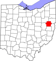 | |
| Townships | ||
| CDP | ||
| Unincorporated communities | ||
| Footnotes | ‡This populated place also has portions in an adjacent county or counties | |