Rose Township, Carroll County, Ohio
| Rose Township, Carroll County, Ohio | |
|---|---|
| Township | |
|
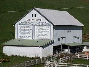
Sign at township garage | |
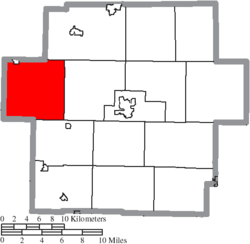 Location of Rose Township in Carroll County | |
| Coordinates: 40°36′56″N 81°15′57″W / 40.61556°N 81.26583°WCoordinates: 40°36′56″N 81°15′57″W / 40.61556°N 81.26583°W | |
| Country | United States |
| State | Ohio |
| County | Carroll |
| Area | |
| • Total | 35.51 sq mi (91.98 km2) |
| • Land | 35.49 sq mi (91.93 km2) |
| • Water | 0.02 sq mi (0.05 km2) |
| Elevation[1] | 994 ft (303 m) |
| Population (2010) | |
| • Total | 1,537 |
| • Density | 43/sq mi (16.7/km2) |
| Time zone | Eastern (EST) (UTC-5) |
| • Summer (DST) | EDT (UTC-4) |
| Area code(s) | 330 |
| FIPS code | 39-68420[2] |
| GNIS feature ID | 1085835[1] |
| Website | http://rosetownshipohio.com/ |

Rose Township is one of the fourteen townships of Carroll County, Ohio, United States. As of the 2010 census, the population was 1,537,[3] 1,271 of whom lived in the unincorporated portions of the township.
Geography
Located in the western part of the county, it borders the following townships:
- Sandy Township, Stark County - north
- Brown Township - northeast
- Harrison Township - east
- Monroe Township - southeast
- Warren Township, Tuscarawas County - southwest
- Sandy Township, Tuscarawas County - west
- Pike Township, Stark County - northwest corner
Rose Township is the northwesternmost township of the Old Seven Ranges of the Ohio Lands. The Geographer's line along the north boundary of the township was completed on August 10, 1786,[4] marked by the Seven Ranges Terminus, which is now on the National Register of Historic Places.[5][6]
Part of the village of Magnolia is located in northwestern Rose Township.
Name and history
Named after the many wild roses growing in the area,[7] it is the only Rose Township statewide.[8]
In 1818, Rose Township was formed from a part of Sandy Township in Stark County.[9] Before the formation of Carroll County, it was a part of Stark County.[7]
Government
| Historical population | |||
|---|---|---|---|
| Census | Pop. | %± | |
| 1820 | 380 | — | |
| 1830 | 978 | 157.4% | |
| 1840 | 1,593 | 62.9% | |
| 1850 | 1,537 | −3.5% | |
| 1860 | 1,286 | −16.3% | |
| 1870 | 1,106 | −14.0% | |
| 1880 | 1,195 | 8.0% | |
| 1890 | 1,196 | 0.1% | |
| 1900 | 1,638 | 37.0% | |
| 1910 | 1,218 | −25.6% | |
| 1920 | 1,314 | 7.9% | |
| 1930 | 1,072 | −18.4% | |
| 1940 | 1,234 | 15.1% | |
| 1950 | 1,230 | −0.3% | |
| 1960 | 1,373 | 11.6% | |
| 1970 | 1,181 | −14.0% | |
| 1980 | 1,289 | 9.1% | |
| 1990 | 1,384 | 7.4% | |
| 2000 | 1,603 | 15.8% | |
| 2010 | 1,537 | −4.1% | |
| [10] | |||
The township is governed by a three-member board of trustees, who are elected in November of odd-numbered years to a four-year term beginning on the following January 1. Two are elected in the year after the presidential election and one is elected in the year before it. There is also an elected township fiscal officer,[11] who serves a four-year term beginning on April 1 of the year after the election, which is held in November of the year before the presidential election. Vacancies in the fiscal officership or on the board of trustees are filled by the remaining trustees.
The current office holders and end of their terms are:[12]
Trustees:
- Jonathan W. J. Ward - Term ending December 31, 2017,
- John Joe Little - Term ending December 31, 2017,
- Joe Owens - Term ending December 31, 2015
Fiscal Officer (Clerk):
- Bruce W. Downes - Term ending March 31, 2016
Rose Township has one voting precinct. The polling place is the social hall at St. Mary's of Morges.[13]
Cemeteries
The township maintains five cemeteries.[14]
Roads
The township maintains 33 miles of roads, maintained by one appointed employee.[15]
Education
Students attend the Carrollton Exempted Village School District in the eastern part and Sandy Valley Local School District in the center and west part.[16]
From the mid 19th to early 20th century the rural areas were served by schools numbered 1 to 9.[17]
References
- 1 2 "US Board on Geographic Names". United States Geological Survey. 2007-10-25. Retrieved 2008-01-31.
- ↑ "American FactFinder". United States Census Bureau. Retrieved 2008-01-31.
- ↑ "Geographic Identifiers: 2010 Demographic Profile Data (G001): Rose township, Carroll County, Ohio". U.S. Census Bureau, American Factfinder. Retrieved January 9, 2015.
- ↑ Fort Steuben history
- ↑ photos of surveyors marker
- ↑ National Park Service (2009-03-13). "National Register Information System". National Register of Historic Places. National Park Service.
- 1 2 "Rose Township History p. 2" (PDF).
- ↑ "Detailed map of Ohio" (PDF). United States Census Bureau. 2000. Retrieved 2007-02-16.
- ↑ Perrin, William Henry, ed. (1881). History of Stark County, with an outline sketch of Ohio. Chicago: Baskin and Battey. p. 205. OCLC 23276454.
- ↑ census data: 1820 : 1820 page 137 , 1830 : Kilbourn, John (1831). The Ohio gazetteer: or, Topographical dictionary: describing the several ... in the State of Ohio. self. p. 332. , 1840, 1880 : Howe, Henry (1907). Historical Collections of Ohio, The Ohio Centennial Edition. The State of Ohio. p. 359. , 1850 : 1850 page 14 , 1860 : 1860 page 13 , 1870 : 1870 page 24 , 1890, 1900 : Hunt, William C. (1901). Population of the United States by states and territories, counties, and minor Civil Divisions, as returned at the Twelfth Census: 1900. United States Census Printing Office. p. 306. , 1900, 1910, 1920 : Austin, William Lane; Teele, Ray Palmer (1921). Fourteenth census of the United States, Volume 1. Government Printing Office. p. 561. , 1930 : 1930 page 40 , 1940 : 1940 page 83 , 1950 : 1950 page 14 , 1960 : 1960 page 16 , 1970 : 1970 page 124 , 1980 : 1980 & 1990 Census Information, at reference desk, Carroll County District Library , 1990 : 1990 , 2000 : 2000
- ↑ §503.24, §505.01, and §507.01 of the Ohio Revised Code. Accessed 4/30/2009.
- ↑ "Elected Officials - Township Trustees and Fiscal Officers". Carroll County Board of Elections. Retrieved 2014-03-07.
- ↑ Carroll County Board of Elections
- ↑ "Cemeteries". Rose Township. Retrieved 2014-03-07.
- ↑ "About the township". Rose Township. Retrieved 2014-03-07.
- ↑ PUC Ohio map of School Districts
- ↑ Rose Township History pp. 9-14
External links
- Township website
- County website
- Gray, Karen (September 2008). "Rose Township Carroll County, Ohio" (PDF). Carroll County Historical Society.
Municipalities and communities of Carroll County, Ohio, United States | ||
|---|---|---|
| Villages | 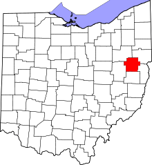 | |
| Townships | ||
| CDP | ||
| Unincorporated communities | ||
| Footnotes | ‡This populated place also has portions in an adjacent county or counties | |