Chiatra
| Chiatra | |
|---|---|
|
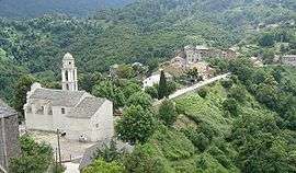
The church and surrounding buildings in Chiatra | |
 Chiatra | |
|
Location within Corsica region  Chiatra | |
| Coordinates: 42°17′34″N 9°28′34″E / 42.2928°N 9.4761°ECoordinates: 42°17′34″N 9°28′34″E / 42.2928°N 9.4761°E | |
| Country | France |
| Region | Corsica |
| Department | Haute-Corse |
| Arrondissement | Corte |
| Canton | Moïta-Verde |
| Government | |
| • Mayor (2008–2014) | Pancrace Lastrajoli-Maurizi |
| Area1 | 8.22 km2 (3.17 sq mi) |
| Population (2008)2 | 213 |
| • Density | 26/km2 (67/sq mi) |
| Time zone | CET (UTC+1) |
| • Summer (DST) | CEST (UTC+2) |
| INSEE/Postal code | 2B088 / 20230 |
| Elevation |
37–743 m (121–2,438 ft) (avg. 408 m or 1,339 ft) |
|
1 French Land Register data, which excludes lakes, ponds, glaciers > 1 km² (0.386 sq mi or 247 acres) and river estuaries. 2 Population without double counting: residents of multiple communes (e.g., students and military personnel) only counted once. | |
Chiatra is a commune in the Haute-Corse department of France on the island of Corsica.
Population
| Historical population | ||
|---|---|---|
| Year | Pop. | ±% |
| 1962 | 229 | — |
| 1968 | 229 | +0.0% |
| 1975 | 206 | −10.0% |
| 1982 | 194 | −5.8% |
| 1990 | 162 | −16.5% |
| 1999 | 190 | +17.3% |
| 2008 | 213 | +12.1% |
See also
References
| Wikimedia Commons has media related to Chiatra. |
This article is issued from Wikipedia - version of the 2/8/2015. The text is available under the Creative Commons Attribution/Share Alike but additional terms may apply for the media files.