Albertacce
| Albertacce | |
|---|---|
|
Chapel Saint Hyacinthe | |
 Albertacce | |
|
Location within Corsica region 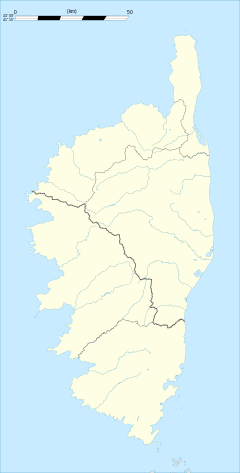 Albertacce | |
| Coordinates: 42°19′41″N 8°59′04″E / 42.3281°N 8.9844°ECoordinates: 42°19′41″N 8°59′04″E / 42.3281°N 8.9844°E | |
| Country | France |
| Region | Corsica |
| Department | Haute-Corse |
| Arrondissement | Corte |
| Canton | Niolu-Omessa |
| Government | |
| • Mayor (2001–2020) | Pierre François Albertini |
| Area1 | 97.12 km2 (37.50 sq mi) |
| Population (2009)2 | 230 |
| • Density | 2.4/km2 (6.1/sq mi) |
| Time zone | CET (UTC+1) |
| • Summer (DST) | CEST (UTC+2) |
| INSEE/Postal code | 2B007 / 20224 |
| Elevation |
785–2,558 m (2,575–8,392 ft) (avg. 867 m or 2,844 ft) |
|
1 French Land Register data, which excludes lakes, ponds, glaciers > 1 km² (0.386 sq mi or 247 acres) and river estuaries. 2 Population without double counting: residents of multiple communes (e.g., students and military personnel) only counted once. | |
Albertacce (in Corsican E Lupertacce, pronounced [e lupɛrˈtattʃe]) is a French commune in the Haute-Corse department in the Corsica region of France.
Geography
Albertacce is a commune of Niolu a long-inaccessible micro-region where invaders were never able to conquer the mountain people, a long bowl cut from the world where there are blond Corsicans with blue eyes and fair skin and has become today the kingdom of hiking. It is located in the heart of the Regional Natural Park of Corsica.
Location
Albertacce is located high in the Corsican mountains some 30 km in a direct line east by north-east of Porto on the west coast and 15 km west by north-west of Corte. The road distance is very substantially longer. Access to the commune is by a single road - the D84 - which branches west from the D18 road just north of Castirla. It then follows the mountain ridge south-west to the village of Albertacce. The D84 continues south west though the middle of the commune and down to the sea at Porto by a very arduous and convoluted route following the mountain ridges. This is the only road in the commune except for two short roads from the village - the D518 to Lozzi, and the D218 to Casamaccioli from south of the village.[1]
Relief

The commune occupies the southwest part of Niolu surrounded by a vast mountainous circle formed of high peaks in the watershed of Golo. Its boundaries are marked as follows:
- to the north and west: by the main mountain range of Corsica, the massif of Cinto with Paglia Orba (2525 m), Capu Tafunatu (2335 m), Capu ae Gharghiole (2105 m), Capu di Guargnerola (1967 m), Punta Cricche (2057 m), the col de Vergio (1478 m), Capu a Rughia (1712 m), Bocca San Pedru (1452 m)
- to the south by the mountains of the Rotondo mountain range, its limits being delineated by the peaks U-Tritore (1725 m) (the southernmost summit), Punta Artica (2327 m) and Capu-di-a-Facciatu (2113 m)
- to the east by a line to the north from Capu-di-a-Facciatu, through Castellu Montone (1493 m), the fold of Tileri (1040 m), joining the Golo downstream of Ponte Altu and along the river to Lake Calacuccia. This line bypasses the village of Albertacce and the hamlets of Pietra-Zitamboli and goes back to Punta Crucetta (2,499 m) along a ridge through Capigliole a e Furchelle (1401 m), Capu di Villa (2184 m) and Capu Falu (2540 m).
In the midst of the basin of shallow siliceous soil which lies on a Hercynian granite base, is the Forest of Valdu Niellu, a vast forest of Corsican pine traversed by the Golo and which occupies the western part of the commune.
To the northeast of Valdu Niellu, between the mountains of Cinto and a ridge linking Crucetta Punta (2499 m), Capu Falu (2540 m), Capu di Inzecca (2299 m), the Cresta di l 'Inzecche, Monte Albanu (2018 m), and the remarkable Cinque Frati (1986 m) is the upper valley of Viru a tributary of the Golo.
The western slopes of the valley are covered by the communal forest of Albertacce composed mainly of Corsican pine. The pine is called lariciu ("a large" in Corsican language) is part of the large family of black pines. It can occur at altitudes between 1000 to 1800 m on sunny slopes. There are nuthatches, non-migratory birds which live on the tree trunks moving head down. There are 2,000 pairs in Corsica.[2]
Along the length of Valdu Niellu on the southern slope of the col de Vergio is another remarkable Corsican pine forest: the Forest of Aïtone (Évisa).
Towards the peaks on the shady side, between 1600 and 2100 metres, pushes the fragrant alder trees (bassu in Corsican). These are shrubs without trunks and rarely exceeds 3 metres high. Its leaves are sticky and its branches were once used by shepherds to cover their huts. The forest is said to be impenetrable. In February the first Crocus corsicus can be seen on the mountains, species unique to the islands of Corsica and Sardinia. On the heights mouflons can be seen from the colony of Cinto.
Hydrography
The hydrographic network includes numerous streams and springs. The river Golo rises from 1991 metres in the commune south of the Paglia Orba (2525 m) and 200 m to the south of the Capu Tafunatu (2335 m). Its course is interrupted by the Calacuccia Dam. It leaves the commune 200 metres upstream of the Mazzola bridge on the D218 road. The Viru, the main tributary of the commune, is fed by several streams such as that of Paglia Orba and Foggiale bordered in part by the GR 20. At the bottom of the creek beds, there are native species: the Tyrrhenian painted frogs (a bariulata) - toads living up to 1900 m and Corsican brook salamanders (a Tarantella). The Corsican brook salamander has no lungs. It breathes through the skin and mouth.
Habitat
The small population of Albertacce is divided between the Albertacce village and the hamlet Pietra Zitamboli, the village Calasima, and in the forest of Valdu Niellu.
Albertacce Village (E Lupertacce)
The village is built on a gentle slope towards the Golo in a remarkable chestnut grove maintained and harvested. Although standing near Lake Calacuccia the limits of the town do not reach the lake. The houses are partly grouped with the shops around the parish church, others are aligned along the D84.
The old buildings were built with red tile roofs and walls built of gray granite. Some massive houses in the baroque style were formerly houses for nobles.
Albertacce has a water tank and a sewage treatment plant.
Pietra (A Petra) and Zitamboli (Zitàmbuli)

Pietra and Zitamboli are two neighbouring hamlets northwest of the village of Albertacce, Zitamboli being located below Pietra. Between the two, a church was built. Its bell tower is similar to that of the parish church of the village and those of neighbouring towns. Access is difficult - both villages are served by the small road D318 that leads to Calasima.
Calasima (Calasima)
Built at 1100 m altitude, Calasima is the highest village in Corsica. Today a hamlet of Albertacce, this village has houses clustered around its church, war memorial and cemetery. Calasima is equipped with a water tank and a sewage treatment plant.
Valdu Niellu
The vast forest Valdu Niellu has some residents. Some people stay at Castellu di Vergio which has a hotel near the snow stadium. In addition, the 2nd Foreign Parachute Regiment of the Foreign Legion has a chalet at Vergio for their training in the mountains. At Poppaghja is the forester's house belonging to the ONF.
Access

Access to Albertacce is by the D84 road which is the only road which crosses the Niolu and serves all the communes of the microregion.
Connecting to the NR193 in the East near Francardo (Omessa) and to the D81 going west to Porto (Ota), the D84 is a road that goes through remarkable attractions: the famous defile of Scala di Santa Regina to the east, the Col de Vergio (1478 m) where there is an imposing statue (6 metres high) of Christ the King by the sculptor Noël Bonardi at the Centre, and the remarkable Gorges de la Spelunca (Marignana) to the west.
To get to Calasima take the D318 road at the village of Albertacce. After the village of Calasima, the road continues for several kilometres in a path along the stream u Viru and ends after a few kilometres at a height of 1096 m.
Neighbouring communes and towns
 |
Manso | Lozzi | Calacuccia | |
| Évisa | |
Casamaccioli | ||
| ||||
| | ||||
| Cristinacce | Soccia |
History
Prehistory
Excavations undertaken since 2006 on the site of A Curnatoghja at Albertacce and also at Sidossi close to the hamlet of Calacuccia on a spur called E Mizane on the lakefront, have revealed some archaeological finds which attest to human presence at the end the Neolithic and the Bronze Age. These include fragments of ceramics, stone tools like shards, a scraper and arrowheads.
The Archaeological Museum of Niolu of Lucien Acquaviva at Albertacce is intended to highlight the specific terminology of megalithic Corsican. A Menhir statue (a stantara) of a Niolu "soldier" wearing a suit of armour, a breastplate of the Peoples of the sea, and a dagger was discovered during the demolition of the chapel of Saint-Jean Baptiste which was decided on in 1985 by the City Council of Calacuccia. This stone called Ghjuvan Battista III was incorporated with two other menhirs into the walls of the chapel Saint-Jean Baptiste of Calacuccia that was next to the church when it was built in the 12th century, probably to confirm the victory of the Catholic religion over pagan rites because in the 7th century, Pope Gregory I claimed that he had repressed the "cult of stones" in Corsica.
Antiquity
According to Ptolemy Corsica was inhabited by twelve nations who, for the indigenous majority, had not been subject to Roman influence to a great extent. Niolu was inhabited by the Licnini, a people who occupied the middle basin of the Golo. Masters of the Casacconi and Ampugnani countries they returned to the mountains, populating the cantons of Caccia and Niolo.[3] The Greeks used the term "Lieninoï" to refer to the people.
Middle Ages
It is also likely that the Saracen colonies of Corte and Balagne, harassed by Christian patriots, were driven back into Niolu where significant names of Calaguccia and Calasima were applied to two villages.[3]
In the 16th century around 1520, the Pieve of Niolu was uninhabited. The Bank of Saint George, which had managed Corsica since 1453, used the troops of Nicolo Doria in 1503 to destroy the houses in the villages of Lozzi, L'Acquale, Erco, Corscia, Calacuccia, Casamaccioli, Sidossi, and Erbechincieby.[4]
The Bank of Saint George did the same with the neighbouring Pieve of Sia (formed by the valley of Porto), ordering the depopulation Sia due to the non-submission of its inhabitants to the Lordship of Leca burning houses and crops.
Modern times

From 1729 Niolu took part in the uprising against Genoa, creating unrest in opposing the publication of judicial decisions. In early March 1730 the people of Niolu occupied Vicu and seized 200 guns in the house of the Lieutenant. On the night of 29 to 30 March 1734, Castineta attacked, at Camputile (Niolu), Ghjacumu Santu Petriconi at the head of 300 Genoese troops - Greeks for the most part - and forced him to retreat to Vicu.
On 13 January 1739 Lieutenant-General Jean-Baptiste Francois des Marets, marquis de Maillebois was appointed army commander of the King in Corsica and he came to Corsica. On 24 June of the same year Niolu submitted to General Maillebois.
From 30 July to 1 August 1751, deputies and prosecutors from the Pieve assembled in Oletta and signed an act of submission to the Republic of Genoa, an act by which the King of France tried to make favourable for the Corsicans. Troops were ready to occupy the Niolu which remained refractory. At the last moment its inhabitants made their submission on 13 August 1751.[5]
On 15 May 1768 the Genoese ceded Corsica to France.
After the conquest of the island by the French troops of Louis XV in 1769, Niolu experienced savage military repression. The French subdued nascent revolts under the Generalship of Pasquale Paoli. At the convent of Saint-François-di-Niolu (in Corsican Conventu San Francescu) at Calacuccia eleven Niolins were hanged from the chestnut trees of the convent on 23 June 1774 on the orders of General Sionville including a man from Albertacce. His name Ghjuvanni Albertini is mentioned on the commemorative plaque at the entrance of the convent.
With the revolution that created the department of Corsica with Bastia as prefecture, the Pieve of Niolu became the Canton of Calacuccia in 1789.
In 1793, the National Convention divided the island into two departments: Golo which included Albertacce and Liamone. These were reunited in 1804 by Napoleon I who reestablished the department of Corsica.
Contemporary era
In 1954, Albertacce became part of the canton of Calacuccia which consists of the communes of: Albertacce, Calacuccia, Casamaccioli, Corscia, and Lozzi.
Between 1971 and 1973 new cantons were created including the canton of Niolu-Omessa created by the forced merger of the former cantons of Omessa and Calacuccia.
Economy
The Niolu is a micro-region in the central north-west of Corsica to the west of Corte. It consists of the communes of Corscia, Calacuccia, Albertacce (E Lubertacce), Lozzi, and Casamaccioli (Casamacciuli). It is located in the Regional Natural Park of Corsica and has always been a land of shepherds and traditions.
The Niolu economy was, until the last century, dominated by pastoralism with regular movements of herds of goats and mouflons in search of pastures. In early autumn shepherds drove their animals to the coastal plains and at the end of spring, they climbed back to the mountain pastures.
The cheese niulincu (Niolo in French) must be tried to really know its character. It has a soft texture but to be really good, it should be a little firm, smooth, and without holes, and be refined throughout its thickness. The old "Migration way" started from Barghiana (Manso), but it can be taken from the end of the D351 road, passing by the Ponte di e Rocce, the col de Caprunale, the refuge of Puscaghia of the PNRC (Évisa), and Capu Tafunatu towards the Col de Vergio in the Albertacce commune.
Although agro-pastoralism fell sharply in the Niolu, there are still a few shepherds who now produce cheeses to modern standards. Charcuterie and chestnut flour are also produced in the commune. The mountains attract more and more visitors and tourism brings new resources to the people and creates jobs.
Nowadays migration trails are almost abandoned. However farms (pigs, goats and more recently cattle) have developed, becoming the main activity of the commune. At the exit to the village to the col de Vergio animals are present in pens and also on the road.
The ski resort of Vergio (Campu di neve) is 22 km from the village and about 1 km before the col de Vergio (1478 m). It does not have as much snow as the resorts of continental Europe. The reason is both a low number of days of snowfall, a thick layer of light snow most of the time, and the slopes are too short - insufficient to satisfy the customers.
In addition, and since 11 May 2010, the fishing association "AAPPMA A NIULINCA" has moved its headquarters to the town hall of Albertacce. This association, with 150 members covering the five communes of the canton, manages the aquatic environment of this beautiful region where the Golo rises.
Administration
Albertacce is one of the five towns of Niolu and one of twelve municipalities in the canton of Niolu-Omessa.
List of successive mayors of Albertacce[6]
| From | To | Name | Party | Position |
|---|---|---|---|---|
| 2001 | 2020 | Pierre-François Albertini |
(Not all data is known)
Demography
In 2009, the commune had 230 inhabitants. The evolution of the number of inhabitants is known through the population censuses conducted in the town since 1793. From the 21st century, a census of municipalities with fewer than 10,000 inhabitants is held every five years, unlike larger towns that have a sample survey every year.[Note 1]
| 1793 | 1800 | 1806 | 1821 | 1831 | 1836 | 1841 | 1846 | 1851 |
|---|---|---|---|---|---|---|---|---|
| - | 715 | 826 | 875 | 940 | 967 | 1,020 | 1,070 | 1,153 |
| 1856 | 1861 | 1866 | 1872 | 1876 | 1881 | 1886 | 1891 | 1896 |
|---|---|---|---|---|---|---|---|---|
| 1,050 | 1,080 | 1,121 | 1,181 | 1,140 | 965 | 1,035 | 1,107 | 1,187 |
| 1901 | 1906 | 1911 | 1921 | 1926 | 1931 | 1936 | 1946 | 1954 |
|---|---|---|---|---|---|---|---|---|
| 1,302 | 1,326 | 1,183 | 1,114 | 1,086 | 1,059 | 1,184 | 1,211 | 1,007 |
| 1962 | 1968 | 1975 | 1982 | 1990 | 1999 | 2006 | 2009 | - |
|---|---|---|---|---|---|---|---|---|
| 429 | 373 | 357 | 323 | 200 | 200 | 225 | 230 | - |
Sources : Ldh/EHESS/Cassini until 1962, INSEE database from 1968 (population without double counting and municipal population from 2006)

Sites and monuments

Natural sites
Golo River
The Golo arises in the extreme west of the commune. It traverses the forest of Valdu Niellu and creates the remarkable Radule Waterfall very close to the GR 20. Further downstream it flows under the bridge of San Rimeriu where the sheep pens of Tillarga are and the ruins of the San Rimeriu chapel. At the approach to the village of Albertacce it passes under the bridge on the D84 road then under the Altu bridge which is a remarkable abandoned Genovese bridge. In summer, the natural pools of Golo are cool havens for the villagers and tourists.
Forest of Valdu Niellu
The territorial forest of Valdu Niellu is backed in the North by the main mountain range of Corsica and on the Northwest flanks of the Rotondo mountain range. It is mostly composed of European black pine with other resinous trees such as birch and fragrant alders (bassu).
Calasima
Calasima is a remarkable village - the highest in Corsica at 1100 m altitude.
-

The Golo upstream of Ponte Altu
-
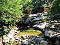
Cuccagna stream in the forest of Valdu Niellu
-
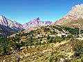
The Villages of Calasima and Paglia Orba
-
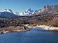
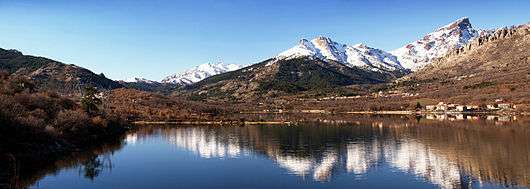
The Golo at Lake Calacuccia
Civil architecture
Ponte Altu

Ponte Altu is a Genovese bridge over the Golo downstream from the D84 highway bridge.
Pont de Muricciolu
This Genovese bridge (Ponte Muricciolu) on the Viru, tributary of the Golo, is located at 852 m above sea level, 1 km towards the vol d'oiseau in the North-east of Ponte Altu and upstream of the confluence of the Viru with the stream of Valdellu. Close to the bridge is an oratory. Both are located on the way to the GR Mare a Mare Nord.
Others
- The Statue of Christ the King at the col de Vergio (1478 m) a monolith 6 metres high carved from a block of pink Corsican granite, with a total height from the base of 9.50 metres. It is the work of the Corsican sculptor Noël Bonardi. It is in the commune of Albertacce, bordering the commune of Évisa along the D84 road. There is a parking area so that the breathtaking scenery can be admired to the full: the Niolu with Lake Calacuccia, the surrounding peaks of the Cinto mountains, and an appreciation of the extent of the vast forests of Valdu Niellu and Aïtone.
- The Calasima War Memorial, located at the entrance of the hamlet. It is the highest war memorial in Corsica, erected at 1093 m altitude.
Sacred architecture

- The 'Parish Church of Saint Mary (Santa Maria) with an isolated bell and exposed stone. The church walls are plastered. On the front right side there are marble plaques on which are inscribed the names of the clergy (priests, deans, canons, and vicars) buried there.
- The Chapel of Saint-Hyacinthe (San Ghjacintu), a building from the 17th century. Located near the parish church, it houses the statue of Saint Roch which was placed there due to lack of space in the parish church.
- The Chapel of Saint-Roch (San Roccu) at the old village.
- The Church of Pietra-Zitamboli. This small church is located between the two hamlets, on a short but steep slope. It has a remarkable door.
- The Church of Calasima. Its bell tower is identical to those of many churches in Niolu.
- The Chapel of San Rimeriu, a ruined chapel about 1050 m above sea level along the Golo.
-

Window at the entrance to the parish church
-

The campanile
-
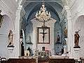
Interior of the church
-

Church of Pietra-Zitamboli
Holidays and leisure
- 16 August: Saint Roch (San Roccu) Albertacce employers party.
- A Santa di u Niolu: Every 8 September there is a celebration of the Nativity of the Virgin in the nearby village of Casamaccioli. The same day the Niolo Fair starts and lasts several days.
Vergio Ski Field
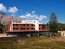
The ski resort of Castellu di Vergio is located about 1.5 km from the col de Vergio (1478 m). The snow stadium is equipped with lifts to serve five pistes and a ski school. It is open all year. There are rest houses, a hotel, and mountain restaurants.
Hiking
- The GR 20 crosses the territory of the commune in its 5th and 6th stages: from Tighjettu to Ciottulu di i Mori and from Ciottulu di i Mori to Manganu.
- The GR Mare a Mare Nord traverses the commune, connecting the col de Vergio to the neighbouring villages of Calacuccia and Évisa. There is a lodging in the village of Albertacce.
- Walks and hikes with a donkey are offered from a beautiful chestnut grove in the village.[7] People can discover the Corsican mountains of Niolu, its many lakes and pastures by taking the hiking trails of the GR 20 or the Mare a Mare Nord on a donkey.
- The trail that extends from the D318, comes to the sheeprun of Ballone (1 hour 30 minutes walk) where it is possible to bivouac, find sheep cheese from the farm as well as drinks and a home cooking restaurant.
Archaeological Museum of Niolu
This museum is not well-known but is on all the guides as the only prehistoric archaeological museum of Haute-Corsica. On display are various objects from excavations on the sites of Sidossi (Calacuccia) and A Curnatoghja at Albertacce. The museum also displays the Stantara di Niolu menhir "soldier".
Others

- A Forest Adventure Park is located near the forester's house of Poppaghia in the forest of Valdu Niellu
- Canyoning and kayaking on the Golo is available in the spring
Notable people linked to the commune
- Prosper Alfonsi, First President of the Corsican Assembly from 20 August 1982 to 24 August 1984
- Pasquine Albertini, author of Sade and the Republic, Paris, L'Harmattan, 2006, 124 p. (coll. Opening Philosophical) (French).[8] Since January 1, 2012, Pasquine Albertini has been the communications director for Shipowners of France, the professional organization of French shipping companies and maritime services
- Jean-Laurent Albertini[9] born 8 September 1949, painter originally from Albertacce. Associate of Fine Arts, he studied at the prestigious Academie Julian (ESAG Penninghen) and the National School of Fine Arts (ENSBA). Today he continues an important artistic work aimed at his region of origin and his goal of expressing what Cézanne described as "my little sensation".
- Jean-Benoit Albertini, born 1963, a native of Albertacce, senior French official.
- Jean-Paul Albertini, a native of Albertacce is a senior French official. Since 29 June 2012 Special Advisor to Delphine Batho, Minister for Ecology, Sustainable Development and Energy.[10]
- Marc-Ange Spinosi, since 2010 the head of the restaurant "L'Accent Corse"[11] located at 123 rue Convention à Paris 15ème.
- Pierre Albertini,[12] originally from Albertacce, a militant in the Movement for Self-Determination (MPA) which was founded in 1990 by Guy Orsoni who was assassinated in Bastia at the age of 34 years on 30 August 1995.
See also
Bibliography
- Corsica in antiquity and the Early Middle Ages, Xavier Poli, Paris Librairie Albert Fontemoing, 1907. (French)
External links
- Albertacce on Lion1906
- Albertacce on Google Maps
- Albertacce on Géoportail, National Geographic Institute (IGN) website (French)
- Albertacce on the INSEE website (French)
- INSEE (French)
Notes and references
Notes
- ↑ At the beginning of the 21st century, the methods of identification have been modified by law No. 2002-276 of 27 February 2002 , the so-called "law of local democracy" and in particular Title V "census operations" which allow, after a transitional period running from 2004 to 2008, the annual publication of the legal population of the different French administrative districts. For municipalities with a population greater than 10,000 inhabitants, a sample survey is conducted annually, the entire territory of these municipalities is taken into account at the end of the period of five years. The first "legal population" after 1999 under this new law came into force on 1 January 2009 and was based on the census of 2006.
References
- ↑ Google Maps
- ↑ FactSheet: Wildlife endemic to Corsica from the National Board of Forestry (French)
- 1 2 Corsica in Antiquity and the High Middle Ages - Xavier Poli, Fontemoing 1907 (French)
- ↑ ADECEC Elements for a Dictionary of Proper Names (French)
- ↑ The Grand Revolt of Corsica against the Genovese 1729-1769, Antoine Dominique Monti, ADECEC, 1979 (French)
- ↑ List of Mayors of France (French)
- ↑ La Promenâne website (French)
- ↑ Online Copy
- ↑ LegiFrance (French)
- ↑ Paris Bistro (French)
- ↑ Blog on Pierre Albertini (French)
| Wikimedia Commons has media related to Albertacce. |