Pietracorbara
| Pietracorbara Pietracurbara | |
|---|---|
|
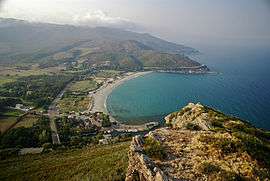
A high view of the bay at Pietracorbara | |
 Pietracorbara | |
|
Location within Corsica region  Pietracorbara | |
| Coordinates: 42°50′00″N 9°28′00″E / 42.8333°N 9.4667°ECoordinates: 42°50′00″N 9°28′00″E / 42.8333°N 9.4667°E | |
| Country | France |
| Region | Corsica |
| Department | Haute-Corse |
| Arrondissement | Bastia |
| Canton | Sagro-di-Santa-Giulia |
| Intercommunality | Cap Corse |
| Government | |
| • Mayor (2008–2014) | Jean-Claude Galletti |
| Area1 | 25.93 km2 (10.01 sq mi) |
| Population (2008)2 | 557 |
| • Density | 21/km2 (56/sq mi) |
| Time zone | CET (UTC+1) |
| • Summer (DST) | CEST (UTC+2) |
| INSEE/Postal code | 2B224 / 20247 |
| Elevation | 0–1,300 m (0–4,265 ft) |
|
1 French Land Register data, which excludes lakes, ponds, glaciers > 1 km² (0.386 sq mi or 247 acres) and river estuaries. 2 Population without double counting: residents of multiple communes (e.g., students and military personnel) only counted once. | |
Pietracorbara is a commune in the Haute-Corse department of France on the island of Corsica.
Population
| Historical population | ||
|---|---|---|
| Year | Pop. | ±% |
| 1962 | 242 | — |
| 1968 | 270 | +11.6% |
| 1975 | 234 | −13.3% |
| 1982 | 229 | −2.1% |
| 1990 | 363 | +58.5% |
| 1999 | 433 | +19.3% |
| 2008 | 557 | +28.6% |
See also
References
External links
- Official website (French)
- A website built by the Petra Viva association (French)
| Wikimedia Commons has media related to Pietracorbara. |
This article is issued from Wikipedia - version of the 8/24/2016. The text is available under the Creative Commons Attribution/Share Alike but additional terms may apply for the media files.