Cholmondeley, Cheshire
| Cholmondeley | |
 Cholmondeley Castle |
|
 Cholmondeley |
|
| Population | 157 (2011) |
|---|---|
| OS grid reference | SJ536513 |
| Civil parish | Cholmondeley |
| Unitary authority | Cheshire East |
| Ceremonial county | Cheshire |
| Region | North West |
| Country | England |
| Sovereign state | United Kingdom |
| Post town | MALPAS |
| Postcode district | SY14 |
| Dialling code | 01829 |
| EU Parliament | North West England |
| UK Parliament | Eddisbury |
Coordinates: 53°03′26″N 2°41′30″W / 53.057088°N 2.691637°W
Cholmondeley (/ˈtʃʌmli/ CHUM-lee)[1] is a civil parish in Cheshire, England, north east of Malpas and west of Nantwich. It includes the small settlements of Croxton Green (SJ552527) and Dowse Green (SJ561517), with a total population of a little over a hundred,[2][1] increasing to 157 at the 2011 Census.[3] Nearby villages include Bickerton to the north east, Bulkeley to the north, Chorley to the east, No Man's Heath to the south west, and Bickley Moss to the south.
The name means "clearing of Ceolmund", this being an Old English forename made up of the elements ceol, "ship", and mund, "protection".[4]
Cholmondeley Castle is in Cholmondeley and much of the civil parish falls within the Cholmondeley Estate, owned by the Marquess of Cholmondeley. Its parkland includes mixed woodland and plantations, lakes, gardens and farmland.
Geography, transport and economy
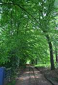
The civil parish has a total area of 2,647 acres (1,071 ha).[5] The Cholmondeley Estate stretches from the A49 in the east to the Cholmondeley lane to the west and the parish boundary to the south; it is designated an area of special county value. The parkland extends to 251.5 hectares.[6] The parish contains part of the large mixed woodland of Moss Wood (centred on SJ542501), as well as Long Plantation (SJ548514), Marl Piece (SJ), Garden Covert (SJ550518), Nevill's Wood (SJ548521), Coronation Wood (SJ542523) and several unnamed smaller woods and plantations. There are two large lakes, Chapel Mere (SJ539518) and Deer Park Mere (SJ540508), as well as several smaller meres. Chapel Mere has been designated as a Site of Special Scientific Interest.[7][8] The high point is 125 metres on Castle Hill in Cholmondeley Park, at SJ532514. The River Weaver runs through the parish from the north west to the south east.[9]
The A49 runs north–south through the parish. Other through routes include an unclassified road running broadly east–west, crossing the A49 at SJ552504, which connects with the settlements of Bickerton, Chorley and Wrenbury.[9]
The land use is predominantly agricultural, with cattle pasture and some arable land. Cholmondeley Park supports rare-breed cattle, sheep and goats, including longhorn cattle.[10] Cholmondeley Castle gardens are a tourist attraction.
Demography
In 2006, the total population of the civil parish was estimated as 130.[5] The 2001 census recorded a population of 136, in 63 households.[2] The population has decreased since 1951; the historical population figures were 292 (1801), 269 (1851), 298 (1901) and 266 (1951).[1]
Cholmondeley Castle and Park
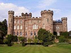
Cholmondeley Castle is a grade-II*-listed castellated mansion house located at SJ536513, 4 miles from Malpas and 7¼ miles from Nantwich. The sandstone building dates from 1801–04; turrets and towers were added in 1817–19 by Robert Smirke to give the "castle" its present appearance.[11] The surviving parts of the grade-II-listed Old Hall date from 1707; the hall formerly included an Elizabethan building which was demolished in 1801.[12]
- Parkland
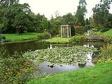
The parkland of the castle was originally laid out in the late 17th century, and is included in the National Register of Historic Parks and Gardens (grade II).[13] The gates at the south-west entrance to the park date from 1722 and are listed at grade II*.[14] The castle gardens contain several grade-II-listed structures; Temple Gardens has a sandstone temple,[15] a lead statue of three winged cherubs supporting a flower basket,[16] a rotunda,[17] a stone bridge over a lily pond carved with dolphins[18] and a gated entrance;[19] the stone bridge across Chapel Mere is also listed.[20]
- Chapel
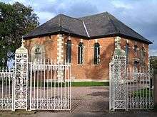
The castle's private chapel, dedicated to St Nicholas, is of a much earlier date and is listed at grade I. The original timber-framed building dates from the late 15th century; it was rebuilt in brick in 1717 by John Vanbrugh and extended during the 19th century.[21] John Betjeman suggests that the attribution to Vanbrugh is incorrect since Thomas Fetherston contracted for the work in 1716. The transepts were added in 1829. The chancel roof is medieval and the furniture of the chancel is of about 1552.[22] The north and south gates to the chapel date from 1722 and were formerly fences to the Old Hall; they are listed at grade II.[23][24]
- Gate lodges
The park has five grade-II-listed gate lodges, Beeston Lodge,[25] Deer Park Lodge,[26] Nantwich Lodge,[27] Park House Lodge[28] and Somerset Lodge.[29] Other estate buildings also listed at grade II include Castle Farm House,[30] Park House,[31] Scotch Farm,[32] Shingles Cottages[33] and The Mews.[34]

Other landmarks
The Cholmondeley Arms public house, a converted schoolhouse on the A49 at SJ552505, is included in the Good Pubs Guide.[35] The Cholmondeley Castle Farm Shop, in the Castle Farm House at SJ531513, sells produce from the Cholmondeley Estate and incorporates a post office.[10]
The grade-II-listed Field's Farmhouse (SJ554507) dates originally from 1648 and was restored in 1903. A three-bay farmhouse with timber framing and brick infilling, it features jetties and close studding with a middle rail.[36] Higginsfield House (SJ557522) was formerly the Cholmondeley Estate's dower house; a five-bay, two-storey, white-painted brick house with a projecting porch, it dates from the early 19th century and is listed at grade II.[37]
Education
Cholmondeley civil parish falls within the catchment areas of Bickerton Holy Trinity CE Primary School in Bickerton and Bishop Heber High School in Malpas.[38][39]
See also
References
- 1 2 3 Genuki: Cholmondeley (accessed 14 August 2007)
- 1 2 Neighbourhood Statistics: Cholmondeley CP (accessed 25 May 2008)
- ↑ "Civil parish poiopulation 2011". Neighbourhood Statistics. Office for National Statistics. Retrieved 16 March 2016.
- ↑ Harrison, Henry. Surnames of the United Kingdom. Clearfield.
- 1 2 Crewe & Nantwich Borough Council: Parish Statistics (downloaded from ; 5 April 2010)
- ↑ Cheshire County Council: Interactive Mapping: Registered Parks and Gardens & Areas of Special County Value (accessed 26 May 2008)
- ↑ Natural England: Chapel Mere (accessed 16 April 2010)
- ↑ Natural England: Nature on the Map: Chapel Mere SSSI (accessed 16 April 2010)
- 1 2 Cheshire County Council: Interactive Mapping: Cholmondeley CP (accessed 25 May 2008)
- 1 2 Castles and Cottages: The View from the Estates. The Sandstone News, issue 3 (June 2005) (downloaded from ; 25 May 2008)
- ↑ Images of England: Cholmondeley Castle (accessed 25 May 2008)
- ↑ Images of England: The Old Hall (accessed 26 May 2008)
- ↑ UKPG Database: Cholmondeley Castle (accessed 25 May 2008)
- ↑ Images of England: Gates and screen across the main (S.W.) approach to Cholmondeley Castle (accessed 26 May 2008)
- ↑ Images of England: Temple in the Temple Gardens (accessed 26 May 2008)
- ↑ Images of England: Lead cherub ornament in Temple Gardens (accessed 26 May 2008)
- ↑ Images of England: Rotunda in the Temple Gardens (accessed 26 May 2008)
- ↑ Images of England: Bridge over Lily Pond in Temple Gardens (accessed 26 May 2008)
- ↑ Images of England: Gated entrance to Temple Gardens (accessed 26 May 2008)
- ↑ Images of England: Stone bridge east of Somerset Lodge (accessed 26 May 2008)
- ↑ Images of England: The chapel of Saint Nicholas (accessed 25 May 2008)
- ↑ Betjeman, J., ed. (1968) Collins Pocket Guide to English Parish Churches: the North. London: Collins; p. 101
- ↑ Images of England: The Chapel North Gates (accessed 26 May 2008)
- ↑ Images of England: The Chapel South Gates (accessed 26 May 2008)
- ↑ Images of England: Beeston Lodge (accessed 26 May 2008)
- ↑ Images of England: Dee Park Lodge (accessed 26 May 2008)
- ↑ Images of England: Nantwich Lodge (accessed 26 May 2008)
- ↑ Images of England: Park House Lodge (accessed 26 May 2008)
- ↑ Images of England: Somerset Lodge (accessed 26 May 2008)
- ↑ Images of England: Castle Farm House (accessed 26 May 2008)
- ↑ Images of England: Park House (accessed 26 May 2008)
- ↑ Images of England: Scotch Farm (accessed 26 May 2008)
- ↑ Images of England: Shingles Cottages (accessed 26 May 2008)
- ↑ Images of England: The Mews (accessed 26 May 2008)
- ↑ The Good Pub Guide: Cholmondeley Arms, Bickley Moss (accessed 15 August 2007)
- ↑ Images of England: Field's Farmhouse (accessed 25 May 2008)
- ↑ Images of England: Higginsfield House (accessed 25 May 2008)
- ↑ Cheshire County Council: Interactive Mapping: Bickerton Holy Trinity CE Primary School (accessed 25 May 2008)
- ↑ Cheshire County Council: Interactive Mapping: Bishop Heber High School (accessed 25 May 2008)
External links
| Wikimedia Commons has media related to Cholmondeley, Cheshire. |
Cheshire Portal | |
| Unitary authorities | |
| Major settlements | |
| Rivers | |
| Topics | |