Peckforton
| Peckforton | |
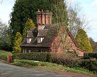
 Black and White Cottage, in Peckforton village centre |
|
 Peckforton |
|
| Population | 269 (Including Ridley. 2011) |
|---|---|
| OS grid reference | SJ538564 |
| Civil parish | Peckforton |
| Unitary authority | Cheshire west and chester |
| Ceremonial county | Cheshire |
| Region | North West |
| Country | England |
| Sovereign state | United Kingdom |
| Post town | TARPORLEY |
| Postcode district | CW6 |
| Dialling code | 01270 |
| EU Parliament | North West England |
| UK Parliament | Eddisbury |
Coordinates: 53°06′11″N 2°41′22″W / 53.102952°N 2.689385°W
Peckforton is a scattered settlement (centred at SJ538564) and civil parish in the unitary authority of Cheshire East and the ceremonial county of Cheshire, England. The settlement is located 6.5 miles (10.5 km) to the north east of Malpas and 7.5 miles (12.1 km) miles to the west of Nantwich. The total population of the civil parish is somewhat over 100, increasing at the 2011 Census to 269.[1] Nearby villages include Bulkeley to the south, Beeston to the north, Higher Burwardsley to the west, Spurstow to the east and Bunbury to the north east.
The Peckforton Hills form the western part of the civil parish. At the northern end of the ridge stands Peckforton Castle, a Victorian mansion built in imitation of a medieval castle for John Tollemache, 1st Baron Tollemache, and many of the local buildings were constructed in the mid-Victorian period for Lord Tollemache as part of the Peckforton Estate.
History
The Peckforton Hills were quarried during the Roman era.[2] Peckforton appears in the Domesday survey of 1086, when it was held by Wulfric. The survey lists land for two ploughs.[3] Peckforton fell in the ancient parish of Bunbury in the Eddisbury Hundred.[4]
Peckforton and the adjacent Beeston were part of an estate purchased by John Tollemache, 1st Baron Tollemache in 1840.[5] Lord Tollemache built Peckforton Castle in 1844–50. Praised as a model landlord, he had over fifty farms and many cottages built on his Cheshire estate, at a cost of around £280,000.[6][7] Labourers were encouraged to rent 3 acres (1.2 ha) of land to farm to supplement their income.[5] The woods that surround the castle were largely planted in 1922.[8] In 2008 the Tollemache family were still the major landowners in Peckforton, although the castle itself was sold in 1989.[9]
Governance
Peckforton has a parish meeting rather than a parish council.[10] From 1974 the civil parish was served by Crewe and Nantwich Borough Council, which was succeeded on 1 April 2009 by the unitary authority of Cheshire East.[11] Peckforton falls in the parliamentary constituency of Eddisbury,[12] which has been represented by Antoinette Sandbach since 2015, after being represented by Stephen O'Brien (1999–2015).
Geography and transport
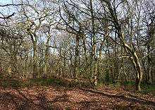
The civil parish has a total area of 1,754 acres (710 ha).[13] The sandstone ridge of the Peckforton Hills runs broadly north–south in the west of the civil parish, with high points at Peckforton Point (SJ529557; 203 metres) and Stanner Nab (SJ531573; 200 metres).[14] A 57.88 hectares area of Peckforton Woods has been designated a Site of Special Scientific Interest, and the hills have also been designated county sites of biological importance for their woodland and grassland habitats.[15][16] The Peckforton Hills are the source of the Weaver and the Gowy rivers; the Weaver flows southwards through the parish, while the Gowy flows northwards.

To the east of Stone House Lane, the land is gently undulating with an elevation mainly within the range of 75–100 metres. The land use in this part of the civil parish is agricultural, predominantly pasture with some arable land. This area also includes the woodland and plantations of Peckforton Moss (SJ542559), Peckforton Wood (SJ554560), Brickkiln Wood (SJ544574) and part of Willis's Wood (SJ542580), as well as Peckforton Mere (SJ541576) and many smaller ponds and meres.[14]
The A49 forms part of the eastern boundary of the civil parish.[14] Stone House Lane runs north–south through the parish, with Peckforton Hall Lane running eastwards from it. The Sandstone Trail long-distance footpath runs along the Peckforton ridge.
Demography
In 2006, the total population of the civil parish was estimated as 150.[13] The 2001 census recorded a population of 116 in 52 households.[17] This represents a decline from historical population figures, which were 260 (1801), 286 (1851), 176 (1901) and 140 (1951).[4]
Peckforton Castle
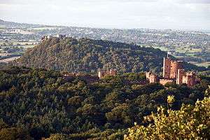
At the northern end of the Peckforton ridge stands the grade-I-listed Peckforton Castle (SJ533580), a Victorian replica of a medieval castle designed by Anthony Salvin in 1844–50 for John Tollemache.[6][18] Built around a walled courtyard with battlements and towers, the castle stands opposite the genuinely medieval Beeston Castle, and is surrounded by a dry moat.[18] George Gilbert Scott called it "the very height of masquerading".[6] Uninhabited since the Second World War, the castle has been used as a film and television location, and as a venue for civil weddings and live-action fantasy role playing.[19][20] The castle was sold in the late 1980s, and after that time was converted into an hotel.[20]
Also by Salvin are the castle's small private chapel and the gatehouse on Stone House Lane. Both, like the castle, are in rock-faced stone. The gatehouse consists of an archway and circular turret with a two-storey lodge attached. Both buildings are listed at grade II*.[21][22]
Other landmarks
Elephant and castle carving

A red sandstone carving depicting an elephant bearing a castle stands in a garden on Stone House Lane in Peckforton village. It dates from around 1859 and is listed at grade II.[23][24] It was carved by John or William Watson, a local stonemason then working on Peckforton Castle who also carved stone lions now at Spurstow and Tattenhall.[23][24] The elephant and the castle are each carved from a single piece of stone, which derives from the same quarry as Peckforton Castle. The elephant has a tasselled saddle, supporting the castle which has three tiers, with a turretted gatehouse and a keep with turrets at the corner. Some of the castle windows are glazed.[23][24]
The original purpose of the carving is unclear. The device formed part of the crest of the Worshipful Company of Cutlers and is often associated with public houses, but there has never been a pub called The Elephant and the Castle in Peckforton.[25] An elephant also appears in the arms of the Corbett family, local landowners before 1626.[24] According to one source, the carving was originally intended as a beehive, although there is no evidence it has ever been used as one.[24]
Listed buildings
Peckforton has a diverse collection of listed buildings. Probably the earliest remaining buildings in the civil parish are Manor Farm Cottage and Yew Tree Cottage, grade-II-listed timber-framed cottages dating from the early 17th century.[26] Black and White Cottage on Stone House Lane is a single-storey, timber-framed, thatched cottage dating from the late 17th century with an attached byre under the same roof; the cottage is listed at grade II* for its unusually well-preserved interior.[27]
Other black-and-white cottages include Garden Cottage and Hillside Cottage in the village, and Hill Lane Cottage on Hill Lane.[28][29][30] Rock Cottage is unusual in being constructed in sandstone, while Smithy Cottage is a timber-framed cottage infilled with a mixture of brick and sandstone.[31][32] On Peckforton Gap in the south of the civil parish stands The Gap, another stone cottage.[33] All date from the late 17th century and are listed at grade II.
To the east of the village on Peckforton Hall Lane stands Peckforton Hall (SJ545565), a grade-II*-listed farmhouse dating from the late 17th century. In red brick with a slate roof, the hall has twin gabled bays with a later ungabled wing.[34] The nearby former farm building of the same date is timber-framed with a mixture of stone, brick and oak boarding; it is also listed at grade II.[35]
Several former Peckforton Estate cottages, built for John Tollemache in around 1860, are listed at grade II. Constructed in red or brown brick, they typically have a single storey with an attic and feature lozenge windows and prominent chimney stacks. Examples include Fountain Cottages, Green Cottage and Mill Beck Cottage.[36][37]
Manor Farm (SJ540564) stands on Peckforton Hall Lane at the east of the village and is typical of farmhouses built for the Peckforton Estate. The farmhouse dates from around 1870 and is in red brick with three bays, lozenge windows and timber studding to the gables. Both the farmhouse and the adjacent farm building of the same date are listed at grade II.[38][39] Hillside Farm (SJ533556) on Stone House Lane south of the village is another former estate farm, also dating from 1870. The farm house and adjacent farm building are grade II listed.[40][41]
Education
There are no educational facilities within the civil parish. The parish falls within the catchment areas of Bunbury Aldersey Church of England Primary School in Bunbury and Tarporley High School in Tarporley.[42]
See also
References
- ↑ "Civil Parish population 2011". Neighbourhood Statistics. Office for National Statistics. Retrieved 16 March 2016.
- ↑ Phillips ADM, Phillips CB. A New Historical Atlas of Cheshire, p. 19 (Cheshire County Council; 2002) (ISBN 0 904532 46 1)
- ↑ Morgan P, ed. Domesday Book: Cheshire, section 2, paragraph 28 (Phillimore; 1978) (ISBN 0 85033 139 0)
- 1 2 Genuki: Peckforton (accessed 10 March 2008)
- 1 2 Peckforton Hills Local Heritage: Peckforton Castle (accessed 11 March 2008)
- 1 2 3 Pevsner N, Hubbard E. The Buildings of England: Cheshire, pp. 300–302 (Penguin Books; 1971) (ISBN 0 14 071042 6)
- ↑ Robinson JM. A Guide to the Country Houses of the North-West, pp. 56–7 (Constable; 1991) (ISBN 0 09 469920 8)
- ↑ Durdey R (2007–2008) John Tollemache and his castle. Cheshire History 47: 75–87
- ↑ Anon. Castles and cottages: The view from the estates. Sandstone News (June 2005) Downloaded at Sandstone News (accessed 11 March 2008)
- ↑ Cheshire County Council: Parish Council Details: Peckforton Parish Meeting (accessed 27 January 2009)
- ↑ Cheshire (Structural Changes) Order 2008
- ↑ Cheshire County Council: Interactive Mapping: Eddisbury (accessed 27 January 2009)
- 1 2 Crewe & Nantwich Borough Council: Parish Statistics (downloaded from ; 5 April 2010)
- 1 2 3 Cheshire County Council: Interactive Mapping: Peckforton (accessed 10 March 2008)
- ↑ Natural England: Nature on the Map (search for "Peckforton Woods", site code 1002189) (accessed 13 February 2008)
- ↑ Borough of Crewe & Nantwich: Nature Conservation Sites (accessed 14 February 2008)
- ↑ Neighbourhood Statistics: Peckforton CP (accessed 12 August 2007)
- 1 2 Images of England: Peckforton Castle (accessed 13 February 2008)
- ↑ IMDb: Titles with locations including Peckforton Castle, Peckforton, Cheshire, England, UK (accessed 15 March 2008)
- 1 2 Peckforton Castle: History (accessed 15 March 2008)
- ↑ Images of England: Chapel in the ward of Peckforton Castle (accessed 10 March 2008)
- ↑ Images of England: Entrance Lodge South-East of Peckforton Castle (accessed 10 March 2008)
- 1 2 3 Images of England: Stone elephant and castle in garden of Elephant and Castle Cottage (accessed 10 March 2008)
- 1 2 3 4 5 Bamford P. Cheshire Curiosities, p. 90 (Dovecote Press; 1992) (ISBN 0 946159 96 3)
- ↑ Frith F, Nicholle D. Cheshire Living Memories (Frith Book Co.; 2004) (ISBN 1859376754). Quoted in Francis Frith: Peckforton photos (accessed 10 March 2008)
- ↑ Images of England: Manor Farm Cottage and Yew Tree Cottage (accessed 10 March 2008)
- ↑ Images of England: Black and White Cottage (accessed 10 March 2008)
- ↑ Images of England: Garden Cottage (accessed 10 March 2008)
- ↑ Images of England: Hillside Cottage (accessed 10 March 2008)
- ↑ Images of England: Hill Lane Cottage (accessed 10 March 2008)
- ↑ Images of England: Rock Cottage (accessed 10 March 2008)
- ↑ Images of England: Smithy Cottage (accessed 10 March 2008)
- ↑ Images of England: The Gap (accessed 10 March 2008)
- ↑ Images of England: Peckforton Hall (accessed 10 March 2008)
- ↑ Images of England: Farm building south-east of Peckforton Hall (accessed 10 March 2008)
- ↑ Images of England: Fountain Cottages (accessed 10 March 2008)
- ↑ Images of England: Green Cottage and Mill Beck Cottage (accessed 10 March 2008)
- ↑ Images of England: Manor Farm House (accessed 10 March 2008)
- ↑ Images of England: Farm buildings east of Manor Farm House (accessed 10 March 2008)
- ↑ Images of England: Hillside Farm House (accessed 10 March 2008)
- ↑ Images of England: Farm building north of Hillside Farm House (accessed 10 March 2008)
- ↑ Cheshire County Council: Interactive Mapping: Primary School Catchment Areas & Secondary School Catchment Areas (accessed 27 January 2009)
External links
| Wikimedia Commons has media related to Peckforton, Cheshire. |
Cheshire Portal | |
| Unitary authorities | |
| Major settlements | |
| Rivers | |
| Topics | |