Wrenbury
| Wrenbury | |
 Canal boats on the Llangollen branch of the Shropshire Union Canal |
|
 Wrenbury |
|
| Population | 1,181 (2011) |
|---|---|
| OS grid reference | SJ597467 |
| Civil parish | Wrenbury cum Frith |
| Unitary authority | Cheshire East |
| Ceremonial county | Cheshire |
| Region | North West |
| Country | England |
| Sovereign state | United Kingdom |
| Post town | NANTWICH |
| Postcode district | CW5 |
| Dialling code | 01270 |
| Police | Cheshire |
| Fire | Cheshire |
| Ambulance | North West |
| EU Parliament | North West England |
| UK Parliament | Eddisbury |
Coordinates: 53°00′58″N 2°36′04″W / 53.016°N 2.601°W
Wrenbury is a village in the civil parish of Wrenbury cum Frith, the unitary authority of Cheshire East, and the ceremonial county of Cheshire, England. It lies on the River Weaver, around 8.5 miles south-west of Crewe.
The civil parish of Wrenbury cum Frith covers the village of Wrenbury and the small settlements of Gaunton's Bank, Pinsley Green, Porter's Hill, Smeaton Wood, Wrenbury Heath and Wrenburywood. It has a total population of around 1,100, being measured at the 2011 Census as 1,181.[1]
History
The village is listed in the Domesday book as Wareneberie,[2] and became Wrennebury in 1230. The name is said to mean "old forest inhabited by wrens".[3] Wrenbury formed part of the extensive lands of William Malbank (also William Malbedeng), who owned much of the Nantwich hundred.[2]
As a chapel attached to St Mary's Church, Acton, Wrenbury was included in the lands donated to the Cistercian Combermere Abbey in around 1180, shortly after the abbey's 1133 foundation by Hugh Malbank, second Baron of Nantwich.[4] In 1539, after the Dissolution, the land was granted to George Cotton,[4] and the Cotton family remained important local landowners for centuries.[5]
A free school by the church was endowed by Ralph Buckley in 1605.[6]
Governance
Wrenbury cum Frith is administered by the Wrenbury-cum-Frith parish council.[7] From 1974 the civil parish was served by Crewe and Nantwich Borough Council, which was succeeded on 1 April 2009 by the unitary authority of Cheshire East.[8] Wrenbury cum Frith falls in the parliamentary constituency of Eddisbury,[9] which has been represented by Antoinette Sandbach since 2015, after being represented by Stephen O'Brien (1999–2015).
Geography and transport
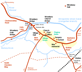
The civil parish has an area of 2,184 acres (884 ha).[7] Wrenbury village lies at an elevation of around 70 metres, about five miles south-west of Nantwich, Cheshire and five miles north-east of Whitchurch, Shropshire. Nearby villages include Marbury, Aston and Audlem.
The village is on the Llangollen branch of the Shropshire Union Canal. It has an unmanned station on the Welsh Marches Railway. The Cheshire Cycleway runs through the village and the South Cheshire Way long-distance path runs just south of it.
Demography
In 2006, the total population of the civil parish was estimated as 1,100.[7] In the 2001 census, the recorded population was 1060.[10] The population has doubled since the beginning of the 20th century; the historical population figures were 404 in 1801, 490 in 1851, 491 in 1901 and 708 in 1951.[11]
Places of worship
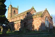
The red sandstone St Margaret's Church, overlooking the village green, dates from the early 16th century. Notable features include a rare example of a dog whipper's pew and a memorial to Stapleton Cotton, 1st Viscount Combermere.[5][12][13] A war memorial stands in the churchyard,[14] which also contains the war graves of a soldier of World War I and a soldier and airman of World War II.[15]
Other landmarks
The centre of Wrenbury village is a conservation area.[16][17] Two black-and-white cottages overlook the village green; Elm House is a Grade II listed cottage with prominent brick chimneys dating from the 17th century,[18] while Stanley House dates from 1859. In the churchyard stands a small Grade II listed black-and-white cottage with brick infill, dating from the 17th century, which is possibly a former almshouse.[19] Hawk House, formerly the Hawk and Buckle inn, is a Grade II listed brick cottage near the post office which dates from the early 18th century.[20] There are also several black-and-white farmhouses and cottages within the Wrenbury cum Frith parish, some of which date from the 17th century.
Wrenbury Hall was the home of the Starkey family, prominent local landowners, until 1920; parts of the house date from the 17th century, although the front was refaced in Elizabethan style in 1916–19.[21] It is said to have been used as shelter for the Parliamentary forces in 1643 when Nantwich was besieged before the Battle of Nantwich, during the Civil War.[21]
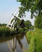
The Shropshire Union Canal near the village has three rare single-span timber lift bridges dating from 1790, which are among Thomas Telford's earliest works. They are of the drawbridge type, with a wooden platform hinged at the north end which is raised and lowered by counterbalancing beam weights. Two are Grade II* listed footbridges; the Grade II listed third bridge now carries road traffic and incorporates a modern mechanical crank.[22]
Education
The Grade II listed red-brick village primary school dates from 1879 and features a bellcote and weathervane.[23] It won the "Champion School" category of the "Your Champions" Awards 2007, sponsored by Scottish Power and Trinity Mirror.[24]
Culture and community
The village has a post office and general stores, and a doctor's surgery.[25] Sports facilities include a pavilion, bowling green, tennis courts and football pitches,[25] and the Wingate Centre, just outside the village, has a 'GymMark'-accredited gymnasium.[26] Local organisations meet at St Margaret's village hall.[25] The mobile library service visits Wrenbury and Wrenbury Heath fortnightly.[27]
The village has two public houses, both of which serve food. The Cotton Arms, named for the Cotton family, is on Cholmondeley Road near the canal.[25] The Dusty Miller occupies a 19th-century corn mill by the canal at Wrenbury Bridge, and is listed in The Good Pub Guide.[28] Facilities for tourists include a caravan site near the canal and the Alvechurch Boat Centre, a boat hire company, which operates from Wrenbury Mill, beside Wrenbury Bridge.[25]
Wrenbury is known for its annual scarecrow trail, which started in 2000. Held the first weekend in July as part of a Summer Fayre, around a hundred and fifty scarecrows were on display in 2006.[29]
Notable residents
The Very Reverend Alan Brunskill Webster (1918–2007), author and Dean of the cathedrals of Norwich and St Paul's, was born in Wrenbury. The son of John Webster, vicar of St Margaret's Church, he lived at the vicarage until 1935.[30][31] Trampolinist Bryony Page was brought up in Wrenbury; she won a silver medal at the 2016 Summer Olympics, Britain's first Olympic medal in the discipline.[32]
See also
References
- ↑ "Civil Parish population 2011". Neighbourhood Statistics. Office for National Statistics. Retrieved 16 March 2016.
- 1 2 The Domesday Book Online: Cheshire L–Z (accessed 11 August 2007)
- ↑ Cheshire Life feature (2002)
- 1 2 'Houses of Cistercian monks: The abbey of Combermere', in A History of the County of Chester, Vol. 3, pp. 150–156, (1980) (accessed 11 August 2007)
- 1 2 Thornber C. Cheshire Antiquities: Wrenbury (accessed 11 August 2007)
- ↑ St Margaret's Churchyard plaque
- 1 2 3 Crewe & Nantwich Borough Council: Parish Statistics (downloaded from ; 5 April 2010)
- ↑ Cheshire (Structural Changes) Order 2008
- ↑ Cheshire East Council & Cheshire West and Chester Council: Interactive Mapping: Eddisbury (accessed 4 June 2010)
- ↑ Neighbourhood Statistics: Wrenbury cum Frith CP
- ↑ Wrenbury cum Frith: Genuki
- ↑ Images of England: Church of St. Margaret
- ↑ Thornber C. Cheshire Antiquities: Cottons of Combermere Abbey
- ↑ United Kingdom National Inventory of War Memorials: St Margarets Church WW1 WW2 (accessed 13 March 2008)
- ↑ CWGC Cemetery Report. Breakdown obtained from casualty records.
- ↑ Borough of Crewe & Nantwich: Replacement Local Plan 2011: Insets: Nantwich Town Centre, Acton, Aston, Audlem, Bridgemere School, Buerton, Hankelow, Marbury, Sound School, Worleston School, Wrenbury (downloaded from ; 4 June 2010)
- ↑ Cheshire East: Conservation Area Appraisals (accessed 4 June 2010)
- ↑ Images of England: Elm House
- ↑ Images of England: Cottage in the Churchyard of St Margaret
- ↑ Images of England: Hawk House
- 1 2 Wrenbury Hall
- ↑ Images of England: Wrenbury Bridge, Wrenbury Church Bridge, Wrenbury Frith Bridge
- ↑ Images of England: Wrenbury School
- ↑ Joule J. Good news (15 November 2007) (accessed 16 April 2008)
- 1 2 3 4 5 Wrenbury Village Website (accessed 11 August 2007)
- ↑ The Wingate Centre (accessed 11 August 2007)
- ↑ Cheshire County Council: Mobile Library Village Details: Wrenbury, Wrenbury Heath (accessed 21 February 2008)
- ↑ The Good Pub Guide: Dusty Miller, Wrenbury (accessed 11 August 2007)
- ↑ Wrenbury Village Website: Scarecrow Trail 2006
- ↑ Local History Group, Latham FA (ed.). Wrenbury and Marbury, p. 67 (The Local History Group; 1999) (ISBN 0 9522284 5 9)
- ↑ Edwards DL. The Very Rev Alan Webster. Independent (5 September 2007) (accessed 17 May 2010)
- ↑ Briggs, Simon (12 August 2016), "Bryony Page and her lucky charm leads to most surprising medal of the Olympics", The Daily Telegraph, retrieved 14 August 2016
External links
| Wikimedia Commons has media related to Wrenbury. |
Cheshire Portal | |
| Unitary authorities | |
| Major settlements | |
| Rivers | |
| Topics | |