Rostherne
| Rostherne | |
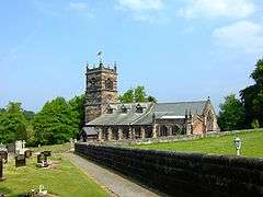 Saint Mary's Church, Rostherne |
|
 Rostherne |
|
| OS grid reference | SJ744837 |
|---|---|
| Civil parish | Rostherne |
| Unitary authority | Cheshire East |
| Ceremonial county | Cheshire |
| Region | North West |
| Country | England |
| Sovereign state | United Kingdom |
| Post town | KNUTSFORD |
| Postcode district | WA16 |
| Dialling code | 01565 |
| Police | Cheshire |
| Fire | Cheshire |
| Ambulance | North West |
| EU Parliament | North West England |
| UK Parliament | Tatton |
Coordinates: 53°21′00″N 2°22′59″W / 53.350°N 2.383°W
Rostherne is a civil parish and village in the unitary authority of Cheshire East and the ceremonial county of Cheshire, England (grid reference SJ743835).
To the north of the village is Rostherne Mere and to the south is Tatton Park. The A556 road passes to its west.
St Mary's Church, Rostherne is a Grade I listed building, which Rectory was for many centuries in the possession of the Leighs of West Hall, High Legh.
See also
External links
![]() Media related to Rostherne at Wikimedia Commons
Media related to Rostherne at Wikimedia Commons
Cheshire Portal | |
| Unitary authorities | |
| Major settlements | |
| Rivers | |
| Topics | |
This article is issued from Wikipedia - version of the 1/23/2016. The text is available under the Creative Commons Attribution/Share Alike but additional terms may apply for the media files.