Churchill, Pennsylvania
| Churchill | |
|---|---|
| Borough | |
|
Beulah Presbyterian Church, built in 1837, and located at Beulah and McCrady Roads in Churchill, PA. | |
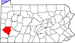
 Location in Allegheny County and the state of Pennsylvania | |
| Coordinates: 40°26′18″N 79°50′38″W / 40.43833°N 79.84389°WCoordinates: 40°26′18″N 79°50′38″W / 40.43833°N 79.84389°W | |
| Country | United States |
| State | Pennsylvania |
| County | Allegheny |
| Area | |
| • Total | 2.2 sq mi (6 km2) |
| • Land | 2.2 sq mi (6 km2) |
| Population (2010) | |
| • Total | 3,011 |
| • Density | 1,400/sq mi (530/km2) |
| Time zone | Eastern (EST) (UTC-5) |
| • Summer (DST) | EDT (UTC-4) |
| Website | Borough of Churchill |
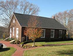
Churchill is a borough in Allegheny County, Pennsylvania, United States. The population was 3,011 at the 2010 census.[1] The town was named from the hilltop Beulah Presbyterian Church.[2]
Geography
Churchill is located at 40°26′18″N 79°50′38″W / 40.43833°N 79.84389°W (40.438418, -79.843827).[3]
According to the United States Census Bureau, the borough has a total area of 2.2 square miles (5.7 km2), all of it land.
Churchill borders five other municipalities: Wilkinsburg, Penn Hills, Wilkins Township and Forest Hills.
Demographics
| Historical population | |||
|---|---|---|---|
| Census | Pop. | %± | |
| 1940 | 430 | — | |
| 1950 | 1,733 | 303.0% | |
| 1960 | 3,428 | 97.8% | |
| 1970 | 4,690 | 36.8% | |
| 1980 | 4,285 | −8.6% | |
| 1990 | 3,883 | −9.4% | |
| 2000 | 3,566 | −8.2% | |
| 2010 | 3,011 | −15.6% | |
| Est. 2015 | 2,979 | [4] | −1.1% |
| Sources:[5][6][7][8][9][10][11] | |||
As of the census[10] of 2000, there were 3,566 people, 1,519 households, and 1,136 families residing in the borough. The population density was 1,624.3 people per square mile (625.8/km²). There were 1,567 housing units at an average density of 713.8 per square mile (275.0/km²). The racial makeup of the borough was 88.50% White, 8.41% African American, 0.14% Native American, 1.93% Asian, 0.03% Pacific Islander, 0.28% from other races, and 0.70% from two or more races. Hispanic or Latino of any race were 1.15% of the population.
There were 1,519 households, out of which 23.7% had children under the age of 18 living with them, 67.2% were married couples living together, 5.7% had a female householder with no husband present, and 25.2% were non-families. 21.9% of all households were made up of individuals, and 10.8% had someone living alone who was 65 years of age or older. The average household size was 2.34 and the average family size was 2.73.
In the borough the population was spread out, with 18.1% under the age of 18, 3.6% from 18 to 24, 22.9% from 25 to 44, 31.7% from 45 to 64, and 23.7% who were 65 years of age or older. The median age was 48 years. For every 100 females there were 93.1 males. For every 100 females age 18 and over, there were 90.4 males.
The median income for a household in the borough was $67,321, and the median income for a family was $74,969. Males had a median income of $52,259 versus $35,464 for females. The per capita income for the borough was $37,964. About 1.8% of families and 3.1% of the population were below the poverty line, including 3.2% of those under age 18 and 2.4% of those age 65 or over.
Transportation
Interstate 376, known (to east of downtown Pittsburgh) as the "Parkway East" by native Pittsburghers, runs through Churchill. Westbound I-376 from Churchill goes to Interstate 279 and downtown Pittsburgh, while eastbound I-376 goes to the Pennsylvania Turnpike. In addition, U.S. Route 22 (on the same road as I-376) travels through Churchill. Several bus lines of the Port Authority of Allegheny County travel through Churchill, offering service to downtown Pittsburgh west of Churchill, and also to Monroeville east of Pittsburgh, where Monroeville Mall and several Port Authority park-and-ride lots for bus commuters are located.
The Parkway East used to end at Churchill (in the traffic configuration just before it was extended to the Turnpike at Monroeville), with traffic having to continue ahead on U.S. 22—now business U.S. 22—to get from there to the Pennsylvania Turnpike. When the Parkway East ended there, there was a black-lettering-on-white-background sign "PARKWAY ENDS", because straight ahead there began to be grade-level intersections.
Education
Churchill Boro is served by the Woodland Hills School District.
See also
References
- ↑ "Race, Hispanic or Latino, Age, and Housing Occupancy: 2010 Census Redistricting Data (Public Law 94-171) Summary File (QT-PL), Churchill borough, Pennsylvania". U.S. Census Bureau, American FactFinder 2. Archived from the original on September 11, 2013. Retrieved September 16, 2011.
- ↑ Porter, Thomas J. Jr. (May 10, 1984). "Town names carry a little bit of history". Pittsburgh Post-Gazette. p. 1. Retrieved 26 May 2015.
- ↑ "US Gazetteer files: 2010, 2000, and 1990". United States Census Bureau. 2011-02-12. Retrieved 2011-04-23.
- ↑ "Annual Estimates of the Resident Population for Incorporated Places: April 1, 2010 to July 1, 2015". Retrieved July 2, 2016.
- ↑ "Population of Civil Divisions Less than Counties" (PDF). 1880 United States Census. U.S. Census Bureau. Retrieved 24 November 2013.
- ↑ "Population-Pennsylvania" (PDF). U.S. Census 1910. U.S. Census Bureau. Retrieved 22 November 2013.
- ↑ "Number and Distribution of Inhabitants:Pennsylvania-Tennessee" (PDF). Fifteenth Census. U.S. Census Bureau.
- ↑ "Number of Inhabitants: Pennsylvania" (PDF). 18th Census of the United States. U.S. Census Bureau. Retrieved 22 November 2013.
- ↑ "Pennsylvania: Population and Housing Unit Counts" (PDF). U.S. Census Bureau. Retrieved 22 November 2013.
- 1 2 "American FactFinder". United States Census Bureau. Archived from the original on 2013-09-11. Retrieved 2008-01-31.
- ↑ "Annual Estimates of the Resident Population". U.S. Census Bureau. Retrieved 22 November 2013.
| Counties |  Map of the Pittsburgh Tri-State with green counties in the metropolitan area and yellow counties in the combined area. | |
|---|---|---|
| Major cities | ||
| Cities and towns 15k-50k (in 2010) | ||
| Airports | ||
| Topics | ||
| ||