Pennsbury Village, Pennsylvania
| Pennsbury Village | |
|---|---|
| Borough | |
|
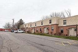
A row of condos on Colony Ct. | |
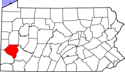
 Location in Allegheny County and the state of Pennsylvania | |
| Coordinates: 40°25′40″N 80°6′3″W / 40.42778°N 80.10083°WCoordinates: 40°25′40″N 80°6′3″W / 40.42778°N 80.10083°W | |
| Country | United States |
| State | Pennsylvania |
| County | Allegheny |
| Area | |
| • Total | 0.1 sq mi (0.3 km2) |
| • Land | 0.1 sq mi (0.3 km2) |
| Population (2010) | |
| • Total | 661 |
| • Density | 6,600/sq mi (2,600/km2) |
| Time zone | Eastern (EST) (UTC-5) |
| • Summer (DST) | EDT (UTC-4) |
Pennsbury Village is a borough in Allegheny County, Pennsylvania, United States. The population was 661 at the 2010 census.[1]
History
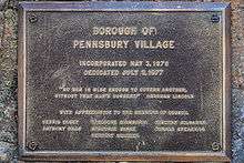
Pennsbury is a unique borough in that it is entirely a municipality of condo-style houses, having been built in 1973. In 1976 there was a disagreement with Robinson Township over proposed sewage treatment fees, which triggered the self-government attempt. In 1977 it separated from the surrounding township and became an Allegheny County borough.[2] The words of the Declaration of Secession included "that we can govern our affairs more effectively and equitable than a distant and disinterested authority". The first council of officials and a mayor were elected and took office in January, 1977.[3]
Geography
Pennsbury Village is located at 40°25′40″N 80°6′3″W / 40.42778°N 80.10083°W.[4]
According to the United States Census Bureau, the borough has a total area of 0.1 square miles (0.26 km2), all of it land.
Surrounding communities
Pennsbury Village is entirely surrounded by Robinson Township.
Demographics
| Historical population | |||
|---|---|---|---|
| Census | Pop. | %± | |
| 1980 | 798 | — | |
| 1990 | 774 | −3.0% | |
| 2000 | 738 | −4.7% | |
| 2010 | 661 | −10.4% | |
| Est. 2015 | 668 | [5] | 1.1% |
| Sources:[6][7][8] | |||
As of the census[7] of 2000, there were 738 people, 491 households, and 152 families residing in the borough. The population density was 12,710.3 people per square mile (4,749.1/km²). There were 500 housing units at an average density of 8,611.3 per square mile (3,217.5/km²). The racial makeup of the borough was 95.93% White, 1.63% African American, 0.81% Native American, 0.81% Asian, 0.14% from other races, and 0.68% from two or more races. Hispanic or Latino of any race were 0.81% of the population.
There were 491 households, out of which 11.0% had children under the age of 18 living with them, 21.2% were married couples living together, 8.4% had a female householder with no husband present, and 69.0% were non-families. 61.9% of all households were made up of individuals, and 5.1% had someone living alone who was 65 years of age or older. The average household size was 1.50 and the average family size was 2.32.
In the borough the population was spread out, with 9.5% under the age of 18, 5.0% from 18 to 24, 50.4% from 25 to 44, 28.7% from 45 to 64, and 6.4% who were 65 years of age or older. The median age was 37 years. For every 100 females there were 68.1 males. For every 100 females age 18 and over, there were 64.1 males.
The median income for a household in the borough was $46,579, and the median income for a family was $55,125. Males had a median income of $42,222 versus $36,528 for females. The per capita income for the borough was $33,339. About 3.8% of families and 3.4% of the population were below the poverty line, including 6.6% of those under age 18 and 11.3% of those age 65 or over.
References
- ↑ "Race, Hispanic or Latino, Age, and Housing Occupancy: 2010 Census Redistricting Data (Public Law 94-171) Summary File (QT-PL), Pennsbury Village borough, Pennsylvania". U.S. Census Bureau, American FactFinder 2. Retrieved September 21, 2011.
- ↑ F A Krift (July 14, 2008). "Big challenges confront small Allegheny County municipalities". Pittsburgh Tribune Review. Retrieved March 26, 2010.
- ↑ "Borough Of Pennsbury Village – Birth of a borough". Retrieved March 26, 2010.
- ↑ "US Gazetteer files: 2010, 2000, and 1990". United States Census Bureau. 2011-02-12. Retrieved 2011-04-23.
- ↑ "Annual Estimates of the Resident Population for Incorporated Places: April 1, 2010 to July 1, 2015". Retrieved July 2, 2016.
- ↑ "Pennsylvania: Population and Housing Unit Counts" (PDF). U.S. Census Bureau. Retrieved 22 November 2013.
- 1 2 "American FactFinder". United States Census Bureau. Retrieved 2008-01-31.
- ↑ "Annual Estimates of the Resident Population". U.S. Census Bureau. Retrieved 22 November 2013.
External links
| Counties |  Map of the Pittsburgh Tri-State with green counties in the metropolitan area and yellow counties in the combined area. | |
|---|---|---|
| Major cities | ||
| Cities and towns 15k-50k (in 2010) | ||
| Airports | ||
| Topics | ||
| ||