Whitaker, Pennsylvania
| Whitaker | |
|---|---|
| Borough | |
|
| |
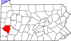
 Location in Allegheny County and the state of Pennsylvania | |
| Coordinates: 40°23′58″N 79°53′12″W / 40.39944°N 79.88667°WCoordinates: 40°23′58″N 79°53′12″W / 40.39944°N 79.88667°W | |
| Country | United States |
| State | Pennsylvania |
| County | Allegheny |
| Government | |
| • Mayor | Daniel R Lassige |
| • Council President | Mike Bogesdorfer |
| • Council Vice President | David Funk |
| • Borough Secretary | Jean Warren |
| • Police Chief | Charles Considine |
| Area | |
| • Total | 0.3 sq mi (0.8 km2) |
| • Land | 0.3 sq mi (0.8 km2) |
| Population (2010) | |
| • Total | 1,271 |
| • Density | 4,200/sq mi (1,600/km2) |
| Time zone | Eastern (EST) (UTC-5) |
| • Summer (DST) | EDT (UTC-4) |
| ZIP codes | 15120 |
| Area code(s) | 412 |
| School District | West Mifflin |
Whitaker is a borough in Allegheny County, Pennsylvania, United States, and is on the Monongahela River 3 miles (5 km) upriver from Pittsburgh. The population was 1,271 at the 2010 census.[1]
The borough is named for James Whitaker, a pioneer settler.[2] Whitaker was incorporated January 4, 1904, from part of the former Mifflin Township.
Geography
Whitaker is located at 40°23′58″N 79°53′12″W / 40.39944°N 79.88667°W (40.399376, -79.886627).[3]
According to the United States Census Bureau, the borough has a total area of 0.4 square miles (1.0 km2), of which 0.3 square miles (0.78 km2) is land and 0.04 square miles (0.10 km2), or 11.76%, is water.[1]
Surrounding communities
Whitaker is bordered by the borough of Munhall to the northwest and by the borough of West Mifflin to the south and east. Across the Monongahela River to the northeast are the boroughs of Rankin and Braddock.
Demographics
| Historical population | |||
|---|---|---|---|
| Census | Pop. | %± | |
| 1910 | 1,547 | — | |
| 1920 | 1,881 | 21.6% | |
| 1930 | 2,072 | 10.2% | |
| 1940 | 2,217 | 7.0% | |
| 1950 | 2,149 | −3.1% | |
| 1960 | 2,130 | −0.9% | |
| 1970 | 1,797 | −15.6% | |
| 1980 | 1,615 | −10.1% | |
| 1990 | 1,416 | −12.3% | |
| 2000 | 1,338 | −5.5% | |
| 2010 | 1,271 | −5.0% | |
| Est. 2015 | 1,254 | [4] | −1.3% |
| Sources:[5][6][7][8][9] | |||
As of the census[5] of 2000, there were 1,338 people, 560 households, and 384 families residing in the borough. The population density was 4,427.0 people per square mile (1,722.0/km²). There were 620 housing units at an average density of 2,051.4 per square mile (797.9/km²). The racial makeup of the borough was 93.65% White, 5.01% African American, 0.60% from other races, and 0.75% from two or more races. Hispanic or Latino of any race were 0.52% of the population.
There were 560 households, out of which 28.9% had children under the age of 18 living with them, 47.7% were married couples living together, 15.7% had a female householder with no husband present, and 31.4% were non-families. 28.0% of all households were made up of individuals, and 12.1% had someone living alone who was 65 years of age or older. The average household size was 2.39 and the average family size was 2.89.
In the borough the population was spread out, with 23.4% under the age of 18, 6.4% from 18 to 24, 30.0% from 25 to 44, 23.2% from 45 to 64, and 17.0% who were 65 years of age or older. The median age was 39 years. For every 100 females there were 101.2 males. For every 100 females age 18 and over, there were 94.1 males.
The median income for a household in the borough was $34,239, and the median income for a family was $39,250. Males had a median income of $29,152 versus $23,409 for females. The per capita income for the borough was $19,910. About 11.9% of families and 14.6% of the population were below the poverty line, including 20.6% of those under age 18 and 10.2% of those age 65 or over.
Notable people
- Jeff Goldblum, actor
References
- 1 2 "Race, Hispanic or Latino, Age, and Housing Occupancy: 2010 Census Redistricting Data (Public Law 94-171) Summary File (QT-PL), Whitaker borough, Pennsylvania". U.S. Census Bureau, American FactFinder 2. Retrieved September 26, 2011.
- ↑ Ackerman, Jan (May 10, 1984). "Town names carry bit of history". Pittsburgh Post-Gazette. p. 6. Retrieved 31 October 2015.
- ↑ "US Gazetteer files: 2010, 2000, and 1990". United States Census Bureau. 2011-02-12. Retrieved 2011-04-23.
- ↑ "Annual Estimates of the Resident Population for Incorporated Places: April 1, 2010 to July 1, 2015". Retrieved July 2, 2016.
- 1 2 "American FactFinder". United States Census Bureau. Retrieved 2008-01-31.
- ↑ "Number of Inhabitants: Pennsylvania" (PDF). 18th Census of the United States. U.S. Census Bureau. Retrieved 22 November 2013.
- ↑ "Annual Estimates of the Resident Population". U.S. Census Bureau. Retrieved 22 November 2013.
- ↑ "Pennsylvania: Population and Housing Unit Counts" (PDF). U.S. Census Bureau. Retrieved 22 November 2013.
- ↑ "Number and Distribution of Inhabitants:Pennsylvania-Tennessee" (PDF). Fifteenth Census. U.S. Census Bureau.
| Counties |  Map of the Pittsburgh Tri-State with green counties in the metropolitan area and yellow counties in the combined area. | |
|---|---|---|
| Major cities | ||
| Cities and towns 15k-50k (in 2010) | ||
| Airports | ||
| Topics | ||
| ||