Clwydian Range

The Clwydian Range (Welsh: Bryniau Clwyd) is a series of hills and mountains in north east Wales that runs from Llandegla in the south to Prestatyn in the north, with the highest point being the popular Moel Famau. The range is designated as an Area of Outstanding Natural Beauty. The AONB has been extended to include the Dee Valley around Llangollen including the Horseshoe Pass and Castell Dinas Bran, extending the area to 150 square miles (389 square km).[1] The highest point in the AONB is Moel y Gamelin at 1,893 feet (577 metres).
Geology
The Clwydian Hills are formed from an upstanding block of Silurian age sandstones, mudstones and siltstones. The range's rocks are intensely faulted; the major Vale of Clwyd Fault is responsible for the impressive west-facing scarp of the Clwydian Range. It downthrows the rocks to the west and separates the younger Carboniferous and Permo-Triassic rocks of the Vale of Clwyd from those of the hills.[2]
The hills
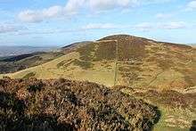
The summits of the hills in the Clwydian Range provide extensive views across northern Wales, to the high peaks of Snowdonia, eastwards across the Cheshire Plain and the Peak District, and towards Manchester and Liverpool to the northeast. They have heather-clad summits above rolling pastures. The Offa’s Dyke National Trail traverses the range from Chirk to Prestatyn and at the southeastern end of the range is Llandegla Forest, a wooded area with mountain bike trails.[3]
The range includes a number of hills possessing Iron Age hillforts, including (from the north) Y Foel (Moel Hiraddug), Moel-y-gaer, Penycloddiau, Moel Arthur, a second Moel y Gaer and Foel Fenlli. There are, as with many places in the west of Britain, a number of legends associated with King Arthur surrounding these hills. There are a number of tumuli and cairns on the hills.[4]
Area of outstanding natural beauty
The Clwydian Range was in 1985 designated as an Area of Outstanding Natural Beauty, one of only five in Wales. The original area was 167 square kilometres (64 sq mi) but in 2011, the area was extended southwards by a further 229 square kilometres (88 sq mi) to include the Dee Valley, the towns of Llangollen and Corwen, the Pontcysyllte Aqueduct, Chirk Castle and Valle Crucis Abbey.[5]
Wildlife
A wide range of wildlife thrives in the range, including red kites and red foxes, which both prey on rabbits and voles. There is also one of the few Welsh populations of Black Grouse and there is a project to conserve the European water vole, which is suffering a large decline in numbers across the United Kingdom. Another project is trying to get rid of the non-native Himalayan balsam which has invaded the Alyn Valley area.[6]
Recreation
The Offa's Dyke Path follows the Clwydian Range, although Offa's Dyke itself was not constructed on it. The Clwydian Way long distance footpath passes through the Clwydian Range, and the North Wales Path follows the foot of the scarp between Prestatyn and Dyserth.[7]
Summits
| # | Peak | Elevation (m) | Grid reference |
|---|---|---|---|
| 1 | Bryn Coed yr Esgob | 211 | SJ068812 |
| 2 | Moel Hiraddug | 265 | SJ063785 |
| 3 | Mynydd y Cwm | 300 | SJ073768 |
| 4 | Moel Maenfa | 290 | SJ085745 |
| 5 | Moel y Parc | 381 | SJ114703 |
| 6 | Penycloddiau | 440 | SJ127678 |
| 7 | Moel Plas-yw | 420 | SJ152669 |
| 8 | Moel Arthur | 456 | SJ145661 |
| 9 | Moel Llys-y-coed | 465 | SJ145655 |
| 10 | Moel Dywyll | 475 | SJ151632 |
| 11 | Moel Famau | 554 | SJ161626 |
| 12 | Moel y Gaer | 339 | SJ148617 |
| 13 | Moel Fenlli | 511 | SJ162600 |
| 14 | Moel Eithinen | 434 | SJ168592 |
| 15 | Gyrn | 384 | SJ165586 |
| 16 | Moel Gyw | 467 | SJ171575 |
| 17 | Moel Llanfair | 447 | SJ169566 |
| 18 | Moel y Plâs | 440 | SJ170554 |
| 19 | Moel y Gelli | 361 | SJ166545 |
| 20 | Moel y Waun | 412 | SJ168534 |
| 21 | Moel yr Acre | 400 | SJ169525 |
References
- ↑ "Clwydian Range and Dee Valley AONB". ClwydianRangeandDeeValleyaonb.org.uk. Retrieved November 4, 2014.
- ↑ "British Geological Survey 1:50K map sheets 107 'Denbigh' & 108 'Flint'". British Geological Survey.
- ↑ "Exploring the Clwydian Range and Dee Valley". Explore Wales. Welsh Government. Retrieved 25 April 2016.
- ↑ "Ordnance Survey 1:25K map sheet 265 'Clwydian Range/Bryniau Clwyd". Ordnance Survey.
- ↑ "Clwydian Range and Dee Valley Area of Outstanding Natural Beauty". Denbighshire Countryside Services. Retrieved 25 April 2016.
- ↑ "Wildlife projects". Clwydian Range and Dee Valley AONB. Retrieved 25 April 2016.
- ↑ "Clwydian Way". North Wales Area of The Ramblers Association. Retrieved 25 April 2016.
External links
Coordinates: 53°11′N 3°15′W / 53.183°N 3.250°W
