Cobbler Creek Recreation Park
| Cobbler Creek Recreation Park South Australia | |
|---|---|
|
IUCN category III (natural monument or feature) | |
 Cobbler Creek Recreation Park | |
 Cobbler Creek Recreation Park | |
| Coordinates | 34°46′46.56″S 138°41′27.23″E / 34.7796000°S 138.6908972°ECoordinates: 34°46′46.56″S 138°41′27.23″E / 34.7796000°S 138.6908972°E |
| Established | 26 October 1989[1] |
| Area | 266 hectares (660 acres)[1] |
| Managing authorities | Department of Environment, Water and Natural Resources |
| Website | Cobbler Creek Recreation Park |
| See also | Protected areas of South Australia |
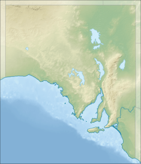
Cobbler Creek Recreation Park is a 266-hectare (657-acre) protected area located in South Australia about 19 kilometres (12 mi) north of the Adelaide city centre in the suburb of Gulfview Heights. Originally part of the lands of the Kaurna aboriginal people, it was farmed from European settlement of South Australia until the declaration of the park in 1989.
The park provides an open space barrier between Golden Grove and the suburbs of Salisbury, has dams to mitigate flooding and is a significant site for both public recreation and native flora and fauna conservation. It is bounded by main roads and bisected by a four-lane main connecting road.
Structure and climate
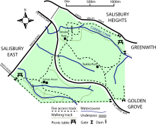
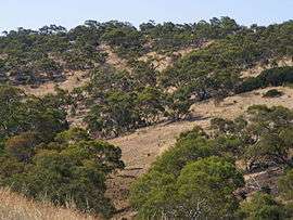
Cobbler Creek Recreation Park is a 266-hectare (657-acre) protected area located about 19 kilometres (12 mi) north of the Adelaide city centre within the suburb of Gulfview Heights.[2] The park is bounded by Bridge and Smith roads, and Green Valley Drive. The Grove Way, a major divided road, runs through the park with a pedestrian underpass connecting the two park sections. The park is open to the public and includes three formed walking trails and two ruins. The remains of William Pedler's home "Trevalsa" and another's called "Teakles House" lie next to one of the trails. There are no public facilities except for benches, signage and picnic tables.[3] "Kelway House", originally belonging to the Kelway Park farm that occupied much of the park, remains as office accommodation for park management staff.[4]
The park lies on the border between the dry northern Adelaide Plains and the wetter Mount Lofty Ranges. Based on climate measurements for nearby Parafield Airport, the park has an average rainfall of 465 millimetres (18 in), an average winter daily temperature range of 6.2—15.6 degrees Celsius and a summer range of 16.5—29.7.[5] Due to the risk of flooding after heavy rain, the park’s waterways have been dammed, though they are dry for much of the year.[6] The park’s topography ranges from steadily sloping in the west, to hilly in the east. Its lowest point, on the western edge along Bridge road, is 70 metres (230 ft) above sea level, rising to 215 metres (705 ft) at the Para Trigonometric Point in the park's southeastern corner. Flat land on the western side has red-brown soil with the remainder having Terra Rosas, Redzinas and fine-textured mallee soils.[7]
Cobbler Creek itself begins in the hills to the west of Golden Grove and joins with Slate Creek prior to entering the park. It is used to collect stormwater from the Tea Tree Gully area as it passes through both farmland and suburbs. After leaving the park the creek passes through housing developments, into wetlands and eventually to the Barker Inlet.[8]
The recreation park is classified as an IUCN Category III protected area.[9]
Prior use of the land
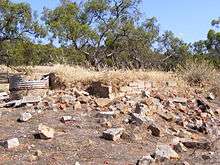
After European settlement the land was used for farming. William Pedler (1850-1916), emigrated to the colony from Cornwall in 1838. He was one of the first to farm the area and from his home made shoes and boots for the colony's Governor[3] and for teamsters carting ore to Burra. Peddler received a land grant of 66 acres (27 ha) at Cobbler creek in early 1853, later passing the property onto his sons.[10] His profession gave both the creek that passes through the northern part of the park, and the park their names.[11] Pedler's farm occupied the flatter, western area of land near Bridge Road. Much of the park was a farm known as "Kelway Park"; a homestead of the same name remains in the park’s south-west. In the 19th century, Salisbury residents used this area for Sunday school picnics. Swings were temporarily built, water and food brought to the site and games and bands provided for entertainment.[12]
Investigations have found no evidence of land use prior to European settlement, although the park forms part of the traditional lands of the Kaurna aboriginal people.[5] It is likely that the Kaurna used the area during winter for food and shelter, moving to the coast to escape summer heat.[13]
History
In a 1962 government report, the park’s area was identified for use as future open space. A golf course was proposed, as were other sporting facilities. The course was re-proposed in 1981 and again in the 1990 management plan. The park was purchased by the Government of South Australia in 1970, as part of a program preserving open space for recreation. The park's location was chosen to provide a development-free buffer between the existing suburbs of Salisbury and the proposed Golden Grove development. It was owned and managed by the State Planning Authority until 1982 when control passed to the National Parks and Wildlife Service. Cobbler Creek was declared a recreation park in 1989, at which point some of the land remained leased for agriculture.[14] The Golden Grove Indenture Act (1984) committed the government to build certain access roads to the new suburb of Golden Grove. Based on the provisions of section 7A-1 in the act, in June 1987 cabinet approved the building of Grove Way. The road is a 4-lane divided connecting road, begun in September 1988 and completed in 1990.[15]
Cobbler Creek Recreation Park is administered and maintained jointly by the City of Salisbury, and the Department of Environment, Water and Natural Resources. A volunteer group, Friends of Cobbler Creek, was formed in 1990 and works with rangers to improve and maintain the park.[16]
Flora and fauna

While sections of the park have are cleared (owing to past land uses), other areas feature grassland, river red gum (Eucalyptus camaldulensis), and mallee box (Eucalyptus porosa). The park contains some of the last remaining mallee box grassy woodland in Adelaide. Amongst the woodlands, plants like the blue-flowering flax lily are common.[13]
Most of the lower, western parts of the park were cleared for pasture and cropping until the early 1970s. While there is remnant vegetation on higher ground, introduced pasture grasses and associated weeds dominate much of the understorey.[7] Perennial native grasses, such as kangaroo grass (Themeda triandra), have been used as part of the park's revegetation. Many of the introduced grasses dry in summer and pose a greater fire hazard than the regrowth. To combat this hazard, and protect surrounding residential areas, annual burns are held particularly around the park's margins. These burns also serve to encourage native vegetation to dominate over introduced weeds.[13]
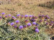
Due to the park's perceived modest conservation values, the 1990 management plan called only for specific control of proscribed weeds rather than an eradication plan for all introduced species.[17] Cobbler Creek park has a wide range of native plants including quandong, ruby saltbush (Enchylaena tomentosa, desert cassia (Cassia eremophila), weeping pittosporum and umbrella wattle (Acacia ligulata).[13]
Native fauna species have been greatly reduced by past agricultural practices and the introduced rabbit is now common.[18] Eastern bearded dragons, White's skink, eastern brown snake, and sleepy lizard reptile species are seen; a total of twenty species have been seen within the park.[19] Black-shouldered kites and nankeen kestrels hunt over the grasslands. red-rumped parrots and crested pigeons are seen feeding on the ground and wattlebirds, musk lorikeets, noisy miners and honeyeaters in the flowering gums and along creeklines.[13] The park is home to a small population of the worm-like and vulnerable Flinders Ranges worm-lizard (Aprasia pseudopulchella).[20]
Recreation
Recreational use of the park is encouraged. There are some picnic facilities provided and dogs are allowed to be walked while on leads. The park includes three named walking trails—Mai Tappa, Babbler and Porosa— that largely follow formed management tracks. The trails pass by the park's ruins and both these and natural sights are highlighted by interpretive signs.[13]
Mountain bike riding was prohibited within the park and illegal trail bike riding was common.[21] However, as of 2013 shared use trails have been built for walkers and mountain bike riders.
See also
Notes
- 1 2 "Protected Areas Information System - reserve list (as of 16 July 2015)" (PDF). Department of Environment Water and Natural Resources. Retrieved 3 August 2015.
- ↑ Department of Environment and Planning (1990), p.3
- 1 2 Tilbrook K. (2003), pp.22-25
- ↑ Department of Environment and Planning (1990), p.20
- 1 2 Department of Environment and Planning (1990), p.4
- ↑ Department of Environment and Planning (1990), p.35
- 1 2 Department of Environment and Planning (1990), p.9
- ↑ Jolly, Beryl. "Wells and Waterways". Tea Tree Gully and district historical society inc. Archived from the original on 2009-07-24. Retrieved 2009-01-12.
- ↑ "Terrestrial Protected Areas of South Australia (see 'DETAIL' tab)". CAPAD 2012. Australian Government - Department of the Environment. 2014. Retrieved 13 March 2015.
- ↑ "The Pedler Family". Tea Tree Gully and district historical society inc. Archived from the original on 2009-10-25. Retrieved 2009-01-12.
- ↑ Lewis (1980), p.24
- ↑ Lewis (1980), p.54
- 1 2 3 4 5 6 "Cobbler Creek Recreation Park (pdf)" (PDF). Department for Environment and Heritage. October 2006. Retrieved 2007-01-31.
- ↑ Department of Environment and Planning (1990), p.III,13,21
- ↑ Department of Environment and Planning (1990), p.14
- ↑ "Friends of Cobbler Creek". Retrieved 2007-01-31.
- ↑ Department of Environment and Planning (1990), P.30
- ↑ Department of Environment and Planning (1990), p.12
- ↑ "Cobbler Creek Recreation Park: Information Sheet" (PDF). Department for Environment and Heritage. 1 January 2007. Archived from the original (PDF) on 5 September 2007. Retrieved 2007-05-13.
- ↑ Mitchell D J (1993)
- ↑ Various news reports, particularly
News Limited: The Messenger (Salisbury), 15 June 2005 and 2 November 2005
References
- Department of Environment and Planning (1990). Cobbler Creek Recreation Park, Management Plan. Adelaide, South Australia: Department of Environment and Planning. ISBN 0-7308-1258-8.
- Lewis, John H. (1980). Salisbury South Australia, A history of town and district. Hawtorndene, South Australia: Investigator Press. ISBN 0-85864-049-X.
- Mitchell, D J (1993). "A survey of the reptiles of the Cobbler Creek Recreation Park, Salisbury East, South Australia". Herpetofauna. The Australian herpetological society (22): 36–37.
- Tilbrook, Kym (2003). Walk SA. Adelaide, South Australia: Advertiser Enterprises. ISBN 0-947148-10-8.
External links
- Cobbler Creek Recreation Park webpage
- Friends of Cobbler Creek Recreation Park website
- "Alphabetical list of flora species in the park" (PDF). (93 kB) (2004, Department for Environment and Heritage)
| Wikimedia Commons has media related to Cobbler Creek Recreation Park. |