Corinna, Maine
| Corinna, Maine | |
|---|---|
| Town | |
|
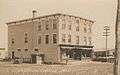
Downtown in 1908 | |
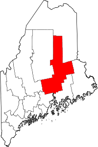
 Corinna, Maine Location within the state of Maine | |
| Coordinates: 44°56′44″N 69°15′23″W / 44.94556°N 69.25639°WCoordinates: 44°56′44″N 69°15′23″W / 44.94556°N 69.25639°W | |
| Country | United States |
| State | Maine |
| County | Penobscot |
| Incorporated | 1816 |
| Area[1] | |
| • Total | 39.46 sq mi (102.20 km2) |
| • Land | 38.68 sq mi (100.18 km2) |
| • Water | 0.78 sq mi (2.02 km2) |
| Elevation | 312 ft (95 m) |
| Population (2010)[2] | |
| • Total | 2,198 |
| • Estimate (2012[3]) | 2,192 |
| • Density | 56.8/sq mi (21.9/km2) |
| Time zone | Eastern (EST) (UTC-5) |
| • Summer (DST) | EDT (UTC-4) |
| ZIP code | 04928 |
| Area code(s) | 207 |
| FIPS code | 23-14310 |
| GNIS feature ID | 0582419 |
| Website |
www |

Corinna is a town in Penobscot County, Maine, United States. The population was 2,198 at the 2010 census.[4] It is part of the Bangor metropolitan statistical area.
History
It was first called T4 R4 NWP (or Township 4, Range 4, North of the Waldo Patent). On June 30, 1804, Dr. John Warren of Boston bought 23,040 acres (93 km2) on speculation from Massachusetts for two cents an acre, or $460.80. To encourage settlement, he gave away some land and built a combination gristmill and sawmill. The town would be incorporated on December 11, 1816, as Corinna, named after Dr. Warren's daughter.[5][6]
The first homes were built of hewn logs. Corinna developed into a farming community, with water powered mills at the outlet of Corundel Lake. After the arrival of the Dexter and Newport Railroad in 1865-1866, the village developed into a small mill town. Industries would include sawmills, planing mills, woolen textile mills, and a door, sash and blind factory. There were also boot and shoemaking shops and an iron foundry.[7] The Eastland Woolen Mill manufactured woolen materials from the 1930s until it closed in 1997, after which it was demolished.[8] The town is now largely a bedroom community of Bangor.
-

Soldiers' Monument c. 1912
-
Odd Fellows' Hall c. 1912
-
%2C_Maine%2C_from_Robert_N._Dennis_collection_of_stereoscopic_views.jpg)
Fisher residence c. 1870
Historic building
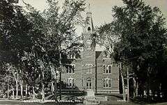
The Stewart Free Library (1898), a gift to the town by Corinna-born Minneapolis millionaire Levi M. Stewart, was designed by Minneapolis architect William Harrison Grimshaw. The library is listed on the National Register of Historic Places, and contains well-preserved historic interiors as well as a majestic facade with clocktower. It resembles a mid-western county courthouse more than a typical small-town Maine library. The Corinna Union Academy educated students in the town from 1851 to 1968.
A memorial dedicated to the soldiers that have died in the War on Terror is located near the river. It is made out of marble and incised with the names of fallen soldiers.
Geography
According to the United States Census Bureau, the town has a total area of 39.46 square miles (102.20 km2), of which, 38.68 square miles (100.18 km2) of it is land and 0.78 square miles (2.02 km2) is water.[1] Situated beside Corundel Lake, Corinna is drained by the East Branch Sebasticook River and Alder Stream, both part of the Kennebec River watershed.
The town is located at the intersection of Route 7 (Dexter Road), Route 11 (Exeter Road) and Route 43 (St. Albans Road), and is centered between the towns of Exeter, St. Albans, Dexter and Newport, about 8 miles (13 km) north of Interstate 95. Corinna is also located on the Newport/Dover-Foxcroft Rail Trail, which was developed along a former Maine Central Railroad line after tracks and ties were removed in 1993.[9]
Climate
This climatic region is typified by large seasonal temperature differences, with warm to hot (and often humid) summers and cold (sometimes severely cold) winters. According to the Köppen Climate Classification system, Corinna has a humid continental climate, abbreviated "Dfb" on climate maps.[10]
Demographics
| Historical population | |||
|---|---|---|---|
| Census | Pop. | %± | |
| 1820 | 411 | — | |
| 1830 | 1,079 | 162.5% | |
| 1840 | 1,704 | 57.9% | |
| 1850 | 1,550 | −9.0% | |
| 1860 | 1,597 | 3.0% | |
| 1870 | 1,513 | −5.3% | |
| 1880 | 1,503 | −0.7% | |
| 1890 | 1,207 | −19.7% | |
| 1900 | 1,170 | −3.1% | |
| 1910 | 1,237 | 5.7% | |
| 1920 | 1,394 | 12.7% | |
| 1930 | 1,485 | 6.5% | |
| 1940 | 1,515 | 2.0% | |
| 1950 | 1,752 | 15.6% | |
| 1960 | 1,895 | 8.2% | |
| 1970 | 1,700 | −10.3% | |
| 1980 | 1,887 | 11.0% | |
| 1990 | 2,196 | 16.4% | |
| 2000 | 2,145 | −2.3% | |
| 2010 | 2,198 | 2.5% | |
| Est. 2014 | 2,189 | [11] | −0.4% |
2010 census
As of the census[2] of 2010, there were 2,198 people, 926 households, and 622 families residing in the town. The population density was 56.8 inhabitants per square mile (21.9/km2). There were 1,075 housing units at an average density of 27.8 per square mile (10.7/km2). The racial makeup of the town was 97.2% White, 0.3% African American, 0.3% Native American, 0.2% Asian, 0.1% from other races, and 1.9% from two or more races. Hispanic or Latino of any race were 0.6% of the population.
There were 926 households of which 28.8% had children under the age of 18 living with them, 50.8% were married couples living together, 9.7% had a female householder with no husband present, 6.7% had a male householder with no wife present, and 32.8% were non-families. 25.3% of all households were made up of individuals and 11.4% had someone living alone who was 65 years of age or older. The average household size was 2.37 and the average family size was 2.81.
The median age in the town was 43 years. 22.5% of residents were under the age of 18; 7% were between the ages of 18 and 24; 22.9% were from 25 to 44; 30.7% were from 45 to 64; and 16.9% were 65 years of age or older. The gender makeup of the town was 48.6% male and 51.4% female.
2000 census
As of the census[13] of 2000, there were 2,145 people, 842 households, and 621 families residing in the town. The population density was 55.5 people per square mile (21.4/km²). There were 981 housing units at an average density of 25.4 per square mile (9.8/km²). The racial makeup of the town was 98.18% White, 0.42% African American, 0.14% Native American, 0.09% Asian, 0.23% from other races, and 0.93% from two or more races. Hispanic or Latino of any race were 0.51% of the population.
There were 842 households out of which 31.0% had children under the age of 18 living with them, 60.0% were married couples living together, 8.2% had a female householder with no husband present, and 26.2% were non-families. 21.0% of all households were made up of individuals and 10.7% had someone living alone who was 65 years of age or older. The average household size was 2.55 and the average family size was 2.89.
In the town the population was spread out with 24.9% under the age of 18, 7.4% from 18 to 24, 28.0% from 25 to 44, 24.4% from 45 to 64, and 15.4% who were 65 years of age or older. The median age was 39 years. For every 100 females there were 99.5 males. For every 100 females age 18 and over, there were 99.6 males.
The median income for a household in the town was $32,115, and the median income for a family was $37,900. Males had a median income of $28,707 versus $17,500 for females. The per capita income for the town was $17,345. About 14.1% of families and 19.5% of the population were below the poverty line, including 26.4% of those under age 18 and 8.5% of those age 65 or over.
Site of interest
Education
Corinna is part of Regional School Unit #19. Mike Hammer is the Superintendent of Schools.[14]
Notable people
- Grenville C. Emery, founder of Harvard-Westlake School
- Sam Fifield, Wisconsin politician
- Gilbert Patten, author
References
- 1 2 "US Gazetteer files 2010". United States Census Bureau. Retrieved 2012-12-16.
- 1 2 "American FactFinder". United States Census Bureau. Retrieved 2012-12-16.
- ↑ "Population Estimates". United States Census Bureau. Archived from the original on 2013-06-17. Retrieved 2013-07-06.
- ↑ "Geographic Identifiers: 2010 Demographic Profile Data (G001): Corinna town, Penobscot County, Maine". U.S. Census Bureau, American Factfinder. Retrieved November 15, 2012.
- ↑ Coolidge, Austin J.; John B. Mansfield (1859). A History and Description of New England. Boston, Massachusetts. p. 96.
- ↑ Chadbourne, Ava H. (May 12, 1951). "Six Maine towns bear women's names". Lewiston Evening Journal. pp. 2A. Retrieved 18 October 2015.
- ↑ Varney, George J. (1886), Gazetteer of the state of Maine. Corinna, Boston: Russell
- ↑ Eastland Woolen Mill -- "Wiping the Slate Clean: Corinna's New Horizon"
- ↑ Maine State Planning Office, "Newport/Dover-Foxcroft Rail Trail"
- ↑ Climate Summary for Corinna, Maine
- ↑ "Annual Estimates of the Resident Population for Incorporated Places: April 1, 2010 to July 1, 2014". Retrieved June 4, 2015.
- ↑ "Census of Population and Housing". Census.gov. Archived from the original on May 11, 2015. Retrieved June 4, 2015.
- ↑ "American FactFinder". United States Census Bureau. Archived from the original on 2013-09-11. Retrieved 2008-01-31.
- ↑ Regional School Unit #19
External links
- Town of Corinna official website
- Stewart Free Library
- Natural Resources Council of Maine page on Newport/Dover-Foxcroft Rail Trail