Farmington, Maine
| Farmington, Maine | ||
|---|---|---|
| Town | ||
|
Downtown Farmington | ||
| ||
| Nickname(s): F-Town, Farmtown, The Farm | ||
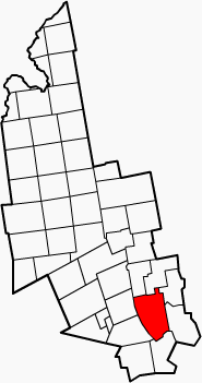 Location in Franklin County, Maine | ||
 Farmington Location within the state of Maine | ||
| Coordinates: 44°40′8.37″N 70°8′46.96″W / 44.6689917°N 70.1463778°WCoordinates: 44°40′8.37″N 70°8′46.96″W / 44.6689917°N 70.1463778°W | ||
| Country | United States | |
| State | Maine | |
| County | Franklin | |
| Incorporated | February 1, 1794 | |
| Area[1] | ||
| • Total | 55.82 sq mi (144.57 km2 km2) | |
| • Land | 55.67 sq mi (144.18 km2 km2) | |
| • Water | 0.15 sq mi (0.39 km2 km2) | |
| Elevation | 425 ft (130 m) | |
| Population (2010)[2] | ||
| • Total | 7,760 | |
| • Estimate (2012[3]) | 7,678 | |
| • Density | 139.4/sq mi (53.8/km2) | |
| Time zone | Eastern (UTC-5) | |
| • Summer (DST) | Eastern (UTC-4) | |
| ZIP codes | 04938, 04992, 04940 | |
| Area code(s) | 207 | |
| Website | farmington-maine.org | |

Farmington is a town in and the county seat of Franklin County, Maine, United States.[4] As of the 2010 census, the town population was 7,760. Farmington is home to the University of Maine at Farmington, the Nordica Memorial Auditorium, the Homestead, and the annual Farmington Fair.
History
The area was once territory of the Canibas tribe of Abenaki Indians. They had two camps located near Farmington Falls, with fields cleared for cultivation of maize and potatoes. Their fort's stockade enclosed about an acre at the center of what is today Farmington Falls village. A group from Topsham arrived in 1776 to explore the area and lay out a town, called Plantation No. 1 or Sandy River Plantation, but permanent settlement was delayed by the Revolutionary War.[5]
In 1781, the first settlers arrived, the same year a sawmill was established. On February 1, 1794, Sandy River Plantation was incorporated as Farmington, named for its unusually fertile soil. Beginning with a cluster of log houses at Farmington Falls, the town grew quickly and prospered. Agriculture was an important early occupation, with hay a principal product. Orchards yielded apples and other fruit. Farmington became one of the largest wool producing towns in New England, with many herds of sheep grazing the hills and intervales.[6]
The town's water power attracted industry, including five lumber mills, two sash, blind and door factories, two brickyards, a foundry, a rake factory, three gristmills, nearly a dozen carriage factories, a cheese factory, two corn canning factories, two reaper machine factories, a spool factory and a tannery.[7] As a regional center for manufacturing, trade and agriculture, Farmington was designated county seat when Franklin County was formed in 1838.[8] In 1859, the Androscoggin Railroad completed its line from Leeds Junction to Farmington, carrying freight and tourists.[5]
In 1879, the town became the southern terminus for the narrow gauge Sandy River Railroad (later part of the Sandy River and Rangeley Lakes Railroad), making it a gateway to the Rangeley Lake and Sugarloaf Mountain areas. Farmington suffered a devastating fire on October 22, 1886, when thirty-three houses, nineteen stores, three churches, the county jail and the post office were destroyed. The 1877 Methodist Church designed by noted architect Arthur H. Vinal survived.[7] Farmington is today a college town and resort area.
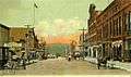 Broadway c. 1905
 Jacob Abbott home in 1906
 Farmington Falls in 1907
Geography
According to the United States Census Bureau, the town has a total area of 55.82 square miles (144.57 km2), of which, 55.67 square miles (144.18 km2) of it is land and 0.15 square miles (0.39 km2) is water.[1] Farmington is drained by Wilson Stream, Temple Stream, Beaver Brook and the Sandy River.
The town is crossed by U.S. Route 2 and Maine State Routes 4, 27, 43, 133, and 149. It borders the towns of Industry and New Sharon to the east, Chesterville to the south, Wilton to the southwest, Temple to the west, and Strong and New Vineyard to the north.
Farmington is divided up into four local areas and is sometimes mapped as such. These areas are West Farmington, Fairbanks, Farmington Falls, and Farmington (downtown). All areas except Fairbanks have their own zip code, but they are all still within Farmington's town limits.
Climate
Typically for Maine, Farmington has a humid continental climate (Köppen Dfb) with cold (sometimes severely cold) winters and warm, often humid summers.[9] Winters are cold and snowy, with forty nights per year under 0 °F or −17.8 °C and 68.6 days failing to top freezing. Snow cover peaks in February at typically around 18 inches or 0.46 metres, but the maximum reached is 84 inches or 2.13 metres on February 28, 1969. The coldest month since records began in 1893 has been January 1982 with an average of 3.4 °F or −15.9 °C, and the hottest July 1921 with an average of 73.3 °F or 22.9 °C, including twelve days over 90 °F or 32.2 °C,[10] whilst the coldest winter was that of 1917/1918 with an average temperature of 10.45 °F or −12.0 °C. The hottest day was August 3, 1975 which reached 101 °F or 38.3 °C, whilst the coldest temperature has been −39 °F or −39.4 °C on January 20, 1994.
Precipitation is abundant throughout the year, with snowfall especially heavy in winter – the wettest calendar month has been December 1969 with 15.49 inches or 393.4 millimetres including 41.0 inches (1.04 m) of snow and a fall from a warm front of 9.97 inches or 253.2 millimetres of precipitation (mostly rain) on December 27 and 28. The snowiest season was that from July 1968 to June 1969 with total snowfall of 164.0 inches or 4.17 metres, whilst the least snowy was from July 1980 to June 1981 with 43.0 inches or 1.09 metres.
| Climate data for Farmington, Maine (1971-2000; extremes 1926-2001) | |||||||||||||
|---|---|---|---|---|---|---|---|---|---|---|---|---|---|
| Month | Jan | Feb | Mar | Apr | May | Jun | Jul | Aug | Sep | Oct | Nov | Dec | Year |
| Record high °F (°C) | 62 (17) |
61 (16) |
77 (25) |
90 (32) |
96 (36) |
100 (38) |
98 (37) |
101 (38) |
95 (35) |
90 (32) |
75 (24) |
65 (18) |
101 (38) |
| Average high °F (°C) | 25.9 (−3.4) |
30.2 (−1) |
39.0 (3.9) |
51.5 (10.8) |
65.4 (18.6) |
73.7 (23.2) |
78.6 (25.9) |
76.9 (24.9) |
68.1 (20.1) |
56.7 (13.7) |
43.2 (6.2) |
31.2 (−0.4) |
53.4 (11.9) |
| Average low °F (°C) | 2.9 (−16.2) |
6.4 (−14.2) |
17.5 (−8.1) |
28.9 (−1.7) |
38.2 (3.4) |
47.9 (8.8) |
53.2 (11.8) |
51.4 (10.8) |
41.9 (5.5) |
33.1 (0.6) |
25.7 (−3.5) |
11.9 (−11.2) |
29.9 (−1.2) |
| Record low °F (°C) | −39 (−39) |
−37 (−38) |
−25 (−32) |
−2 (−19) |
20 (−7) |
27 (−3) |
32 (0) |
29 (−2) |
20 (−7) |
11 (−12) |
−14 (−26) |
−31 (−35) |
−39 (−39) |
| Average precipitation inches (mm) | 3.73 (94.7) |
2.81 (71.4) |
4.03 (102.4) |
4.10 (104.1) |
3.97 (100.8) |
4.50 (114.3) |
3.65 (92.7) |
3.94 (100.1) |
3.73 (94.7) |
4.06 (103.1) |
4.20 (106.7) |
3.94 (100.1) |
46.66 (1,185.1) |
| Average snowfall inches (cm) | 22.8 (57.9) |
17.4 (44.2) |
16.3 (41.4) |
7.3 (18.5) |
0.0 (0) |
0.0 (0) |
0.0 (0) |
0.0 (0) |
0.0 (0) |
0.4 (1) |
5.9 (15) |
19.4 (49.3) |
89.5 (227.3) |
| Average precipitation days (≥ 0.01 inch) | 11.0 | 8.8 | 12.0 | 11.6 | 12.2 | 13.2 | 12.1 | 11.5 | 10.7 | 11.0 | 12.2 | 12.4 | 138.7 |
| Average snowy days (≥ 0.01 inch) | 6.8 | 5.0 | 4.5 | 2.5 | 0.0 | 0.0 | 0.0 | 0.0 | 0.0 | 0.3 | 2.4 | 6.0 | 27.5 |
| Source: National Oceanic and Atmospheric Administration [11] | |||||||||||||
Demographics
| Historical population | |||
|---|---|---|---|
| Census | Pop. | %± | |
| 1800 | 942 | — | |
| 1810 | 1,639 | 74.0% | |
| 1820 | 1,938 | 18.2% | |
| 1830 | 2,341 | 20.8% | |
| 1840 | 2,613 | 11.6% | |
| 1850 | 2,725 | 4.3% | |
| 1860 | 3,106 | 14.0% | |
| 1870 | 3,251 | 4.7% | |
| 1880 | 3,353 | 3.1% | |
| 1890 | 3,207 | −4.4% | |
| 1900 | 3,288 | 2.5% | |
| 1910 | 3,210 | −2.4% | |
| 1920 | 3,197 | −0.4% | |
| 1930 | 3,600 | 12.6% | |
| 1940 | 3,743 | 4.0% | |
| 1950 | 4,677 | 25.0% | |
| 1960 | 5,001 | 6.9% | |
| 1970 | 5,657 | 13.1% | |
| 1980 | 6,730 | 19.0% | |
| 1990 | 7,436 | 10.5% | |
| 2000 | 7,410 | −0.3% | |
| 2010 | 7,760 | 4.7% | |
| Est. 2014 | 7,610 | [12] | −1.9% |
2010 census
As of the census[2] of 2010, there were 7,760 people, 3,072 households, and 1,597 families residing in the town. The population density was 139.4 inhabitants per square mile (53.8/km2). There were 3,441 housing units at an average density of 61.8 per square mile (23.9/km2). The racial makeup of the town was 96.9% White, 0.3% African American, 0.4% Native American, 0.3% Asian, 0.1% Pacific Islander, 0.3% from other races, and 1.7% from two or more races. Hispanic or Latino of any race were 1.3% of the population.
There were 3,072 households of which 23.1% had children under the age of 18 living with them, 38.2% were married couples living together, 9.9% had a female householder with no husband present, 3.9% had a male householder with no wife present, and 48.0% were non-families. 34.1% of all households were made up of individuals and 13% had someone living alone who was 65 years of age or older. The average household size was 2.17 and the average family size was 2.75.
The median age in the town was 32.1 years. 16% of residents were under the age of 18; 27.2% were between the ages of 18 and 24; 18.3% were from 25 to 44; 23.3% were from 45 to 64; and 15.5% were 65 years of age or older. The gender makeup of the town was 45.3% male and 54.7% female.
2000 census
As of the census of 2000, there were 7,410 people, 2,813 households, and 1,533 families residing in the town. The population density was 132.8 people per square mile (51.2/km2). There were 3,048 housing units at an average density of 54.6 persons/sq mi (21.1 persons/km2). The racial makeup of the town was 97.48% White, 0.20% African American, 0.30% Native American, 0.65% Asian, 0.03% Pacific Islander, 0.40% from other races, and 0.94% from two or more races. 0.82% of the population were Hispanic or Latino of any race.
There were 2,813 households out of which 24.8% had children under the age of 18 living with them, 42.5% were married couples living together, 9.1% have a woman whose husband does not live with her, and 45.5% were non-families. 31.7% of all households were made up of individuals and 11.8% had someone living alone who was 65 years of age or older. The average household size was 2.25 and the average family size was 2.87.
In the town the population was spread out with 18.4% under the age of 18, 25.0% from 18 to 24, 21.5% from 25 to 44, 19.3% from 45 to 64, and 15.9% who were 65 years of age or older. The median age was 32 years. For every 100 females there were 81.0 males. For every 100 females age 18 and over, there were 75.1 males.
The median income for a household in the town was $26,814, and the median income for a family was $33,656. Males had a median income of $27,569 versus $21,101 for females. The per capita income for the town was $13,982. About 18.0% of families and 22.6% of the population were below the poverty line, including 30.6% of those under the age of 18 and 5.4% ages 65 or older.
Government
Farmington is the largest town, and county seat, of Franklin County. As a result, it has a number of regional administrative buildings such as a courthouse and DHHS branch. It is governed by a board of selectmen who meet at Town Hall on alternating Tuesdays at 6:30 PM. Daily administration is by a town manager, and the town holds an annual town meeting in March.
Sites of interest
- Farmington Historical Society
- Nordica Memorial Homestead
- Titcomb Mountain
- Sandy River
- Mount Blue Middle School
- University of Maine at Farmington
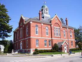
Farmington is home to a number of historic properties and districts. These include the Cutler Memorial Library, Farmington Historic District, First Congregational Church, United Church of Christ, Franklin County Courthouse, Free Will Baptist Meetinghouse, Greenacre, Chester Greenwood House, Merrill Hall, Nordica Homestead, Old Union Meetinghouse, Hiram Ramsdell House and the Tufts House.
University of Maine At Farmington
Farmington is home to The University of Maine at Farmington, part of Maine's Public University system. UMF had a full-time enrollment of 1,800 in 2016.[14]
Neighborhoods
- Downtown Farmington- The main part of town, The downtown has several banks, houses, stores, and public facilities in the town. The University of Maine at Farmington is located next to downtown. Downtown is at the Intersection of Main Street and Broadway Street.
- West Farmington- West Farmington is located at the junction of US Highway 2 and Maine State Route 43. Titcomb Mountain is in West Farmington. The Whistle Stop Rail-Trail startes at Oakes Street and continues to East Wilton, Wilton and Jay. Bikers, Hikers, ATVs, Snowmobiles, and Cross Country Skiers use the Trail. There is also a gas station called Madores. The Zip code is 04992.
- Farmington Falls- Farmington Falls is located at the junction of US Highway 2 and Maine State Route 41 and Maine State Route 156.There are some houses, a church, and a convenience store in the Community. The Sandy River passes through the town too. The zip code is 04940.
- Fairbanks- Fairbanks once housed a school, and has a trading post, along with some restaurants. It is located at the junction of Maine State Route 4 and Maine State Route 27. It is part of the 04938 Zip Code. The Lillian Nordica House is located in Fairbanks.
- Wilton Road- US Highway 2 in Maine passes through Farmington. This area has mostly businesses. There is a Walmart, Hannaford, KFC, Taco Bell, Subway, Pizza Hut and the Ford, GM, and Chrysler dealerships. There are 2 Dunkin Donuts off The Wilton Road. One near Big Lots and one at a Citgo Gas Station. There are other businesses located on Wilton Road. Between West Farmington and Subway, The Speed Limit is 30 MPH, and between Subway and the Comfort Inn at the Town Line it is 40 MPH. After The Comfort Inn it is 50 MPH until East Wilton. The Zip code on Wilton Road is 04938.
- Front Street- Front Street is a Street behind Downtown. There are a few houses before the intersection of Broadway. There is a new restaurant that serves Pizza, and Gelato called the Stone Hearth Cafe. The Narrow Gauge Square has a cinema, and an Eye Doctor, and well as a few stores. Prescott Field is the sports field for baseball, softball, and soccer for the Beavers at the University of Maine at Farmington. Prescott Field is the main way to get to the Sandy River swimming area too. Front Street has a Tavern, and a Farm supply store. Giffords is located on the corner of Main and Front Street. Front Street is considered the Main Street of Historic Farmington.
Prophecy
Farmington is the subject of a prophecy by the Quaker Licia Kuenning (formerly Lisa Bieberman) about a Coming New Order in the town. This was originally prophesied for Tuesday 6 June 2006 but, after gathering more than 80 people together with no apparent miracles on that date, is now prophesied "within the next few years".[15][16]
Notable people

- Edward Abbott, clergyman, journalist, author
- Jacob Abbott, author, educator
- Elizabeth Chase Allen, author, journalist, poet
- Hiram Belcher, US congressman
- Supply Belcher, composer, musician
- Nathan Cutler, politician
- Robert Goodenow, US congressman
- Walter Gooley, state legislator
- Chester Greenwood, the inventor of earmuffs
- S. Clifton Ives, Methodist bishop
- Gregory Kearney, political cartoonist
- Janet T. Mills, state attorney general
- Peter Mills, politician
- Samuel P. Morrill, US congressman and minister
- Lillian Nordica, singer
- Dan Simoneau, cross country skier
- Charlie Webster, state legislator and Chair of the Maine Republican Party
- Seth Wescott, first Olympic gold medalist in Snowboard Cross
- Chandler Woodcock, state senator
See also
References
- 1 2 "US Gazetteer files 2010". United States Census Bureau. Retrieved 2012-12-16.
- 1 2 "American FactFinder". United States Census Bureau. Retrieved 2012-12-16.
- ↑ "Population Estimates". United States Census Bureau. Retrieved 2013-07-06.
- ↑ "Find a County". National Association of Counties. Retrieved 2011-06-07.
- 1 2 Thomas Parker, History of Farmington, Maine, from Its First Settlement to 1846; Farmington, Maine 1875
- ↑ Coolidge, Austin J.; John B. Mansfield (1859). A History and Description of New England. Boston, Massachusetts. pp. 124–126.
- 1 2 Varney, George J. (1886), Gazetteer of the state of Maine. Farmington, Boston: Russell
- ↑ Maine League of Historical Societies and Museums (1970). Doris A. Isaacson, ed. Maine: A Guide 'Down East'. Rockland, Me: Courier-Gazette, Inc. pp. 284–285.
- ↑ Climate Summary for Farmington, Maine
- ↑ National Weather Service Gray/Portland
- ↑ "U.S. Climate Normals" (PDF). National Oceanic and Atmospheric Administration. 2004. Retrieved on July 31, 2015.
- ↑ "Annual Estimates of the Resident Population for Incorporated Places: April 1, 2010 to July 1, 2014". Retrieved June 4, 2015.
- ↑ "Census of Population and Housing". Census.gov. Retrieved June 4, 2015.
- ↑ "About Our Students - University of Maine Farmington". www.umf.maine.edu. Retrieved 2016-06-14.
- ↑ Hanstein, Benjamin (June 7, 2006). "New Jerusalem? No, old Farmington". Sun Journal. Retrieved 3 May 2012.
- ↑ http://www.downeast.com/notes-from-upstream/2009/june/farmington-jerusalem
External links
| Wikimedia Commons has media related to Farmington, Maine. |
| Wikivoyage has a travel guide for Farmington. |
Municipalities and communities of Franklin County, Maine, United States | ||
|---|---|---|
| Towns |  | |
| Plantations | ||
| Unorganized territories | ||
| CDPs | ||
| Other villages | ||