Mount Abraham (Maine)
| Mount Abraham | |
|---|---|
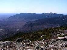
 Mount Abraham seen from the Mount Abraham Side Trail | |
| Highest point | |
| Elevation | 4,050 ft (1,230 m) |
| Prominence | 900 ft (270 m) [1] |
| Listing | New England 4000 footers |
| Coordinates | 44°58.38′N 70°19.59′W / 44.97300°N 70.32650°WCoordinates: 44°58.38′N 70°19.59′W / 44.97300°N 70.32650°W [2] |
| Geography | |
 Mount Abraham | |
| Topo map | USGS Mount Abraham |
Mount Abraham is a mountain located in Franklin County, Maine. Mount Abraham is flanked to the north by Spaulding Mountain.[3]
Watersheds

The northeast side of Mt. Abraham is drained by Rapid Stream, then into the West Branch of the Carrabassett River, the Kennebec River, and into the Gulf of Maine. The southern half of the southwest side drains into Quick Stream, then into the West Branch. The northern half drains into Perham Stream, then into Orbeton Stream, and the Sandy River, another tributary of the Kennebec.
History
The mountain was logged in the late 19th century. Logs were moved down-slope in ice-covered wooden sluices. Logs, lumber, and pulpwood were shipped on the narrow-gauge Sandy River and Rangeley Lakes Railroad.[4]
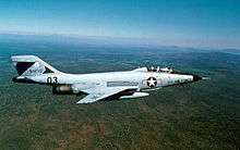
McDonnell F-101B Voodoo No.57-376 of the 60th Fighter-Interceptor Squadron out of Otis AFB, Massachusetts, crashed onto the mountain after colliding with another F-101B during a cross-country formation flight on 14 November 1967. The two-man crew ejected with minor injuries and the second aircraft made an emergency landing at Dow AFB.[5][6]
Access
The Appalachian Trail (AT), a 2,170 mi (3,490 km) National Scenic Trail from Georgia to Maine, runs between Saddleback Junior and Spaulding, passing 2 mi (3.2 km) northwest of the summit of Abraham. The summit of Mount Abraham can be reached from the AT via the blue-blazed Mount Abraham Side Trail.
South side route to the Summit
The South Side Trail head which is a snomobile/ATV trail to the summit of Mount Abraham is located on an unmarked logging road located at Lat/Long 44°57′35″N 70°19′00″W / 44.959666°N 70.31660°W.[7] Directions to the South Side Trailhead of Mount Abraham include navigating through a maze of 7 unnamed dirt logging roads.[8] Access to the south side trailhead requires an off-road capable vehicle to get over logging road washouts.
See also
References
- ↑ "Mount Abraham, Maine". Peakbagger.com.
- ↑ U.S. Geological Survey Geographic Names Information System: Mt. Abraham
- ↑ summitpost.org: Mt. Abraham
- ↑ Jones, Robert C. (1979). Two Feet Between the Rails (Volume 1 - The Early Years). Sundance Books.
- ↑ "The ultimate sacrifice; wreck sites a reminder of military plane disasters". Lewiston Sun Journal. Retrieved 2012-01-19.
- ↑ "McDonnell F-101B Voodoo". Forgotten Jets. Retrieved 2012-01-19.
- ↑ http://www.gorissen.info/Pierre/maps/googleMapLocation.php?lat=44.959666&lon=-70.31660&setLatLon=Set
- ↑ http://maineadventure.net/adventures/directions-mount-abraham-maine.html