Anson, Maine
| Anson, Maine | |
|---|---|
| Town | |
|
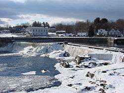
Looking across the falls at downtown Anson, showing the town hall at left. | |
 Anson, Maine Location within the state of Maine | |
| Coordinates: 44°48′41″N 69°53′32″W / 44.81139°N 69.89222°W | |
| Country | United States |
| State | Maine |
| County | Somerset County |
| Area[1] | |
| • Total | 48.29 sq mi (125.07 km2) |
| • Land | 47.49 sq mi (123.00 km2) |
| • Water | 0.80 sq mi (2.07 km2) |
| Population (2010)[2] | |
| • Total | 2,511 |
| • Estimate (2012[3]) | 2,499 |
| • Density | 52.9/sq mi (20.4/km2) |
| Time zone | Eastern (EST) (UTC-5) |
| • Summer (DST) | EDT (UTC-4) |
Anson is a town in Somerset County, Maine, United States. The population was 2,511 at the 2010 census. It includes the villages of Anson and North Anson.
History
This was once territory of the Norridgewock Abenaki Indians. It was first settled in 1772 as Plantation Number One in what would become Somerset County on March 1, 1809. General Benedict Arnold and his troops passed through Anson village in 1775 on their way up the Kennebec River to the ill-fated Battle of Quebec. The town was incorporated on March 1, 1798 as Anson, named after Lord George Anson. On March 20, 1845, North Anson was set off as a separate town, although on March 13, 1855, it reunited with Anson.[4]
With much rich alluvial soil, Anson became an agricultural town. Water power sites around the Carrabassett River helped North Anson develop into a small mill town. In 1859, it had two tanneries. It had two sawmills and three boot and shoe factories in 1886, when the town produced boots, shoes, leather, bricks, lumber, flour and wool rolls. By 1876, North Anson was the northern terminus of the Somerset Railroad, which began at Oakland in 1872. As Madison grew into an industrial center with large paper mills, Anson became a residential district for its mill workers.[5]
As of June 14, 2007, the abandoned Pan Am Railways spur was reopened, and the first train ran the length of the line for the first time in twenty years.[6]
Geography
According to the United States Census Bureau, the town has a total area of 48.29 square miles (125.07 km2), of which, 47.49 square miles (123.00 km2) of it is land and 0.80 square miles (2.07 km2) is water.[1] Anson is drained by Mill Stream, Gilbert Brook, Lemon Stream, the Carrabassett River and the Kennebec River.
The town is crossed by U. S. 201A and state routes 16, 43, 148 and 234. It borders the towns of Starks to the south, Industry and New Vineyard to the west, New Portland and Embden to the north, and (across the Kennebec River) Madison to the east.
Climate
This climatic region is typified by large seasonal temperature differences, with warm to hot (and often humid) summers and cold (sometimes severely cold) winters. According to the Köppen Climate Classification system, Anson has a humid continental climate, abbreviated "Dfb" on climate maps.[7]
Demographics
| Historical population | |||
|---|---|---|---|
| Census | Pop. | %± | |
| 1800 | 373 | — | |
| 1810 | 633 | 69.7% | |
| 1820 | 948 | 49.8% | |
| 1830 | 1,532 | 61.6% | |
| 1840 | 1,941 | 26.7% | |
| 1850 | 848 | −56.3% | |
| 1860 | 2,000 | 135.8% | |
| 1870 | 1,745 | −12.7% | |
| 1880 | 1,555 | −10.9% | |
| 1890 | 1,444 | −7.1% | |
| 1900 | 1,830 | 26.7% | |
| 1910 | 2,209 | 20.7% | |
| 1920 | 2,593 | 17.4% | |
| 1930 | 2,238 | −13.7% | |
| 1940 | 2,130 | −4.8% | |
| 1950 | 2,199 | 3.2% | |
| 1960 | 2,252 | 2.4% | |
| 1970 | 2,168 | −3.7% | |
| 1980 | 2,226 | 2.7% | |
| 1990 | 2,382 | 7.0% | |
| 2000 | 2,583 | 8.4% | |
| 2010 | 2,511 | −2.8% | |
| Est. 2014 | 2,463 | [8] | −1.9% |
2010 census
As of the census[2] of 2010, there were 2,511 people, 1,069 households, and 684 families residing in the town. The population density was 52.9 inhabitants per square mile (20.4/km2). There were 1,300 housing units at an average density of 27.4 per square mile (10.6/km2). The racial makeup of the town was 97.2% White, 0.2% African American, 0.7% Native American, 0.3% Asian, 0.1% from other races, and 1.4% from two or more races. Hispanic or Latino of any race were 1.0% of the population.
There were 1,069 households of which 27.5% had children under the age of 18 living with them, 46.9% were married couples living together, 10.8% had a female householder with no husband present, 6.4% had a male householder with no wife present, and 36.0% were non-families. 27.4% of all households were made up of individuals and 12% had someone living alone who was 65 years of age or older. The average household size was 2.34 and the average family size was 2.79.
The median age in the town was 44.3 years. 20.2% of residents were under the age of 18; 7.1% were between the ages of 18 and 24; 23.9% were from 25 to 44; 31.6% were from 45 to 64; and 17.1% were 65 years of age or older. The gender makeup of the town was 50.2% male and 49.8% female.
2000 census
As of the census[10] of 2000, there were 2,583 people, 1,031 households, and 700 families residing in the town. The population density was 54.4 people per square mile (21.0/km²). There were 1,193 housing units at an average density of 25.1 per square mile (9.7/km²). The racial makeup of the town was 98.34% White, 0.08% Black or African American, 0.50% Native American, 0.04% Asian, and 1.05% from two or more races. Hispanic or Latino of any race were 0.31% of the population.
There were 1,031 households out of which 33.0% had children under the age of 18 living with them, 54.2% were married couples living together, 9.4% had a female householder with no husband present, and 32.1% were non-families. 25.8% of all households were made up of individuals and 12.5% had someone living alone who was 65 years of age or older. The average household size was 2.50 and the average family size was 2.95.
In the town the population was spread out with 25.3% under the age of 18, 7.3% from 18 to 24, 29.3% from 25 to 44, 23.3% from 45 to 64, and 14.9% who were 65 years of age or older. The median age was 38 years. For every 100 females there were 100.2 males. For every 100 females age 18 and over, there were 95.5 males.
The median income for a household in the town was $26,088, and the median income for a family was $30,888. Males had a median income of $24,335 versus $18,194 for females. The per capita income for the town was $12,691. About 12.1% of families and 20.2% of the population were below the poverty line, including 22.5% of those under age 18 and 16.8% of those age 65 or over.
Notable people
- Frank H. Holley, Maine state legislator
- Lloyd T. Pullen, Wisconsin state legislator
References
- 1 2 "US Gazetteer files 2010". United States Census Bureau. Retrieved 2012-12-16.
- 1 2 "American FactFinder". United States Census Bureau. Retrieved 2012-12-16.
- ↑ "Population Estimates". United States Census Bureau. Archived from the original on June 17, 2013. Retrieved 2013-07-06.
- ↑ Coolidge, Austin J.; John B. Mansfield (1859). A History and Description of New England. Boston, Massachusetts. p. 32.
- ↑ Varney, George J. (1886), Gazetteer of the state of Maine. Anson, Boston: Russell
- ↑ https://www.youtube.com/watch?v=MsMj5YM5aGQ
- ↑ Climate Summary for Anson, Maine
- ↑ "Annual Estimates of the Resident Population for Incorporated Places: April 1, 2010 to July 1, 2014". Retrieved June 4, 2015.
- ↑ "Census of Population and Housing". Census.gov. Archived from the original on May 11, 2015. Retrieved June 4, 2015.
- ↑ "American FactFinder". United States Census Bureau. Archived from the original on September 11, 2013. Retrieved 2008-01-31.
External links
Municipalities and communities of Somerset County, Maine, United States | ||
|---|---|---|
| Towns | 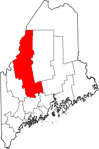 | |
| Plantations | ||
| Unorganized territories | ||
| CDPs | ||
| Other villages | ||