Ferryden Park, South Australia
| Ferryden Park Adelaide, South Australia | |||||||||||||
|---|---|---|---|---|---|---|---|---|---|---|---|---|---|
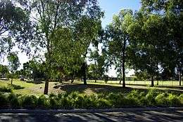
 Richard Day Reserve, facing south-east from York Terrace | |||||||||||||
| Postcode(s) | 5010 | ||||||||||||
| Area | 1.2 km2 (0.5 sq mi) | ||||||||||||
| Location | 9 km (6 mi) from Adelaide | ||||||||||||
| LGA(s) | City of Port Adelaide Enfield | ||||||||||||
| State electorate(s) | Enfield | ||||||||||||
| Federal Division(s) | Port Adelaide | ||||||||||||
| |||||||||||||
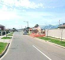
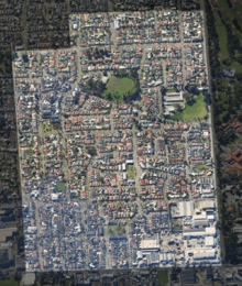
Ferryden Park (postcode 5010) is a north-western suburb of Adelaide 9 km from the central business district, in the state of South Australia, Australia. Situated in the City of Port Adelaide Enfield local government area, it is adjacent to Kilkenny, Angle Park, Woodville Gardens, Croydon Park, and Regency Park. It is bounded to the north by Murray Street, west by Liberty Grove and Hassell Street, south by Regency Road and to the east by Days Road.
The name Ferryden derives from a seaport village on the fringe of Montrose in Scotland.[1] This was the port from which the family of the suburb's founder, William Duthie, emigrated in the 1850s.[1] The suburb contains many street names deriving from traditional Scottish place and family names, such as Montrose, Orkney, Nairn, McDonald, McRostie and Lachlan.
History

Ferryden Park was formed in 1924 by a subdivision of part section 398 of the Hundred of Yatala by William Duthie, dairy man of an area of land known as Tam O'Shanter Belt.[1] Prior to the Second World War, Ferryden Park mainly consisted of pastures, and open land. Its development as a residential area coincided with the post-war boom in the 1950s. In 1947, plans were approved for 80 pairs of SA Housing Trust cottages to be constructed in the vicinity of McRostie and Coker Streets.[2]
In the 1990s, plans were made for the Westwood Urban Renewal Project, of which Angle Park, Mansfield Park, Woodville Gardens, and Athol Park are also a part.[3][4] Ferryden Park was the first suburb to be rejuvenated as part of the project. From 2001 this involved the demolition of many properties of the South Australian Housing Trust which were replaced by private housing, a smaller number of newer, townhouse-style housing trust homes, and new green spaces.
Demographics
Ferryden Park is home to a large immigrant population. As of 2011 43% of the population was born outside Australia.[5]
The initial settlement of the suburb coincided with a large wave of immigrants from Eastern Europe arriving in Australia, following the Second World War. Although most of their children have moved on, a large number of immigrant retirees still live in the area. This was reflected in the peak enrolment at Ferryden Park Primary School in 1959: 639 students. Another wave of immigration occurred in the 1980s, when Vietnamese immigrants arrived after the Vietnam War. As of 2011 12% of residents were born in Vietnam and 19% of residents preferred to speak Vietnamese language at home.[5]
As of 2011 more than half of the population is from a non-Anglophone background, with 53-60% preferring to speak a language other than English at home.[5]
Government
Ferryden Park is located within the federal seat of Port Adelaide. It is a distinctly pro-Australian Labor Party suburb, with the Ferryden Park Primary School booth recording the second highest two-party-preferred (TPP) vote in the state for the ALP at the 1998, 2001 and 2004 federal elections, garnering more than 75% on each occasion. At the 2011 and 2014 elections, after the Ferryden Park polling place had closed, the polling booth in the neighbouring suburb of Woodville Gardens on its west recorded the second highest TPP votes for the ALP.[6] Ferryden Park is in the state government electorate of Enfield and is governed locally by the City of Port Adelaide Enfield being located in that council's Parks ward.[7]
Facilities

There is a small shopping complex along Ridley Grove, including the Ferryden Park post office. The Parks Community Centre in adjoining Angle Park provides a library, health centre, gym and fitness centre, swimming complex, council office, and other community services.
Schools
The Ferryden Park Primary School closed in a merger with other nearby schools in 2010 to form Woodville Gardens B-7 School. It was established in the 1953[1] with around 300–400 students, with enrolment peaking in that decade at over 600. From 2011 the suburb has been served by the newly formed Woodville Gardens B-7 School for primary school aged children.[8][9]
The Parks High School, located adjacent to the Parks Community Centre, was closed in 1996 due to declining enrolments. It was the local zoned high school prior to its closure. From 1996 to 2006, the local zoned high school was Croydon High School, in Croydon. Towards the end of this period a significant number of the families in the area choose to send their children to other schools, such as Woodville High School or schools in the city centre. As a result, Croydon High was forced to close in 2006.
Transport
Liberty Grove is served by the 250, 251 and 252 services,[10] while the 239 service travels along Coker Street and Days Road.[10] The 100 Circle Line services Regency Road[11] along with the city-bound 230, 231 and 232 routes.[10]

Parks and reserves
Ferryden Park contains several parks and reserves. The largest is Ferryden Park Reserve, bordered north, east and south by Wiloughby Street, Sutherland Road and Montrose Street, followed by Richard Day Reserve, bordered east, south and west by Durham Terrace, Lachlan Street and York Terrace respectively. Ferryden Park Reserve contains an all-purpose sports oval and is the home of the Adelaide Olympic football (soccer) club.[12] Other parks in the suburb include Tao Dan Reserve (Sutherland Road), Inverway Street Reserve, Mikawomma Reserve (Ridley Grove) and Shillabeer Reserve (Gainsborough Avenue).[13][14][15][16]
Residents
- Charlie Walsh, previous long-serving coach of the Australian Olympic track cycling team, grew up in Ferryden Park
- Bruce McAvaney, Olympics and horseracing commentator on the Seven Network, grew up in Ferryden Park
Notes
- 1 2 3 4 "Place Names of South Australia - F". The Manning Index of South Australian History. Government of South Australia.
- ↑ "Approval Of Building Plans". Adelaide: The Advertiser. 13 May 1947. Retrieved 2 October 2015.
- ↑ "Westwood Urban Renewal Project Committee". Government of South Australia. Retrieved 5 January 2011.
- ↑ "Westwood". Urban Pacific. Retrieved 5 January 2011.
- 1 2 3 "2011 Census Community Profiles: Ferryden Park - Code SSC40199 (SSC)". 2011 Census. Australian Bureau of Statistics. Retrieved 19 January 2016.
- ↑ Woodville Gardens (adjacent suburb to the west) polling place recorded a two-party-preferred vote of 77.2% for the ALP (56% primary vote), second only to the Pennington polling place's 78.1 % TPP vote for ALP. Sources: AEC: First Preferences By Candidate By Polling Place - SA (CSV 479 KB); AEC: Two Candidate Preferred Flow of Preferences By Polling Place - SA (ZIP 88 KB)
- ↑ "City of Port Adelaide Enfield: Ward Boundary Map" (PDF). City of Port Adelaide Enfield. Retrieved 28 March 2011.
- ↑ "Woodville Gardens School Birth to Year 7 Newsletter November 23, 2010" (PDF). Department of Education and Children's Services, Government of South Australia. 23 November 2010. Retrieved 28 March 2011.
- ↑ "Woodville Gardens School Birth to Year 7 Newsletter December 2010" (PDF). Department of Education and Children's Services, Government of South Australia. December 2010. Retrieved 28 March 2011.
- 1 2 3 "East - West Metroguid" (PDF). AdelaideMetro.com.au. Government of South Australia. January 2011. Retrieved 20 January 2011.
- ↑ "100 Circle Line: Arndale Shopping Centre to Glen Osmond". AdelaideMetro.com.au. Government of South Australia. January 2011. Retrieved 20 January 2011.
- ↑ "Adelaide Olympic Football Club". SACommunity.org. Connecting Up Australia. Retrieved 28 January 2011.
- ↑ "Tao DanReserve". PortEnf.sa.gov.au. City of Port Adelaide Enfield. Retrieved 6 June 2011.
- ↑ "Inverway Street Reserve". PortEnf.sa.gov.au. City of Port Adelaide Enfield. Retrieved 6 June 2011.
- ↑ "Mikawomma Reserve". PortEnf.sa.gov.au. City of Port Adelaide Enfield. Retrieved 6 June 2011.
- ↑ "Shillabeer Reserve". PortEnf.sa.gov.au. City of Port Adelaide Enfield. Retrieved 6 June 2011.
Further reading
- Lewis, H. John (1985). Enfield and the northern villages. The Corporation of the City of Enfield. ISBN 978-0-85864-090-0.
| Wikimedia Commons has media related to Ferryden Park, South Australia. |
Coordinates: 34°51′50″S 138°33′25″E / 34.864°S 138.557°E