Gilles Plains, South Australia
| Gilles Plains Adelaide, South Australia | |||||||||||||
|---|---|---|---|---|---|---|---|---|---|---|---|---|---|
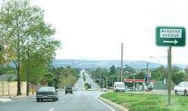 Looking east along Grand Junction Road. Gilles Plains is on the right. | |||||||||||||
| Population | 3,339 (2011)[1] | ||||||||||||
| Postcode(s) | 5086 | ||||||||||||
| LGA(s) | City of Tea Tree Gully | ||||||||||||
| State electorate(s) | Florey & Torrens | ||||||||||||
| Federal Division(s) | Sturt | ||||||||||||
| |||||||||||||
Gilles Plains is a suburb of the greater Adelaide, South Australia area, approximately 15 km north of the Adelaide business district.
History
It is named after the first Colonial Treasurer Osmond Gilles who owned a sheep station adjoining the Torrens River.[2] Gilles Plains was predominantly a hay growing area of Adelaide through its early years. In 1874, it had the largest hay farm in South Australia owned by J. A. W. Sudholz.[3]
Government
Gilles Plains is in both the City of Port Adelaide Enfield and City of Tea Tree Gully local government areas, and is in both the South Australian House of Assembly electoral districts of Florey and Torrens. It is also in the Australian House of Representatives Division of Sturt.
Schools
Burc College is on Wandana Avenue. St Pauls College is on Grand Junction Road. Wandana Primary School is on Cowra Avenue.[4]
Gallery


References
- ↑ www.abs.gov.au (August 2009). "Gilles Plains Demographics". Retrieved 25 August 2009.
- ↑ Ian Auhl (August 1993). "Gilles Plains". Archived from the original on 5 June 2009. Retrieved 25 August 2009.
- ↑ Observer (September 1903). "Obituary". Retrieved 1 September 2009.
- ↑ "Australian Schools Directory". Australian Schools Directory. Retrieved 15 November 2013.
Coordinates: 34°51′01″S 138°39′32″E / 34.85025°S 138.659°E