Eastchester, Bronx

Eastchester is a working class neighborhood in the northeast Bronx borough of New York City in the United States. The neighborhood is part of Bronx Community Board 12. Its boundaries, starting from the north and moving clockwise are: the Bronx-Westchester County border to the north, the New England Thruway to the east, Baychester Avenue to the south, and the intersection of 233rd Street and Baychester Avenue to the west. Boston Road is the primary thoroughfare through Eastchester and Dyre Avenue is the main commercial street. ZIP codes include 10466 and 10475. The area is patrolled by the 47th Precinct located at 4111 Laconia Avenue. Edenwald is a sub-neighborhood located within Eastchester.
History
The neighborhood was historically heavily Ashkenazi-Jewish and Italian-American, It has the same name as a modern-day town located approximately 5 miles to the north, as the neighborhood was included in the Town of Eastchester's extent until the late 19th century upon annexation by the City of New York, its boundaries roughly matching the former Village of Eastchester, which was incorporated on March 25, 1895.[1] The modern-day city of Mount Vernon, located right across the city line and bordering the Eastchester neighborhood, was also once part of the town. While Mount Vernon has developed along similar lines as the neighborhood of Eastchester, the modern-day Town of Eastchester (i.e. north of Mount Vernon) is markedly more affluent.

233rd Street and Boston Road are the major thoroughfares in Eastchester. Intersecting both of these streets, Dyre Avenue is the neighborhood's main commercial strip. There is also a shopping center, Shopwell Plaza (named for the former Shopwell supermarket chain) located on Boston Road next to the Boston-Secor housing project. In 2007 the city's parks department rehabilitated Seton Falls Park.[2]
Since the mid-20th century, the neighborhood's name began to decline in currency, meaning that in recent years residents have not really been cognizant about living in a neighborhood called "Eastchester." This is perhaps due to confusion with Eastchester Road, a thoroughfare which runs through other parts of the Bronx, or with the Town of Eastchester in Westchester County. It is more common to hear the Eastchester neighborhood described as "east of White Plains Road", "south of Mount Vernon", "near Pelham", "East 233rd Street", etc.
Land use and terrain

Eastchester is dominated by one and two family homes of various types, one large public housing project, and an industrial district. The total land area is roughly half a square mile. The area is low laying and flat. The Hutchinson River runs through Eastchester, partly along the line of East 233rd Street. Bridges in Eastchester carry the New England Thruway and Boston Road over the river. A far northeastern portion of Eastchester, on the left bank of the Hutchinson River, is often confused with Pelham Manor since a nearby shopping center is located in that town.
The Boston Secor Houses, comprising four buildings, 13, 14, 17 and 18-stories tall, is located in Eastchester.[3]
Edenwald Houses is the largest New York City Housing Authority development in the Bronx, with forty buildings, 3 and 14-stories tall on 48.88 acres (197,800 m2). It has 2,036 apartments housing about 5,300 people. Completed on October 15, 1953 it is bordered by Grenada Place, East 225th Street, Baychester and Laconia Avenues.[4] The Edenwald Projects is divided into two parts, the northside and the southside, which are split by East 229th street. Bordering the south side is the Edenwald Community Center, which provides afterschool care and programs for the youth. During the summer, the center hosts a summer program for kids and jobs for pre-teens.
Schools
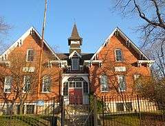
The former Public School 15 was listed on the National Register of Historic Places in 1981.[5] There are three public elementary schools, P.S. 68, P.S. 111, and P.S. 112. Sixth grade to eighth grade students attend John Philip Sousa School Middle School 142. There are no public high schools in the area, however many students attend Harry S. Truman High School in neighboring Co-op City. Those seeking a parochial education can attend Cardinal Spellman High School (co-ed) or either Mount Saint Michael Academy (all boys) in Wakefield or St. Barnabas High School (all girls) in Woodlawn.
Demographics
Eastchester has a population over 5,000. The neighborhood is a mix of African Americans, West Indians, Asians, Hispanics and White. 47.8% of the population lives below the poverty line.[6]
Transportation
Subway service is provided by the IRT Dyre Avenue Line (5 train)
Bus service is provided by New York City Bus and Bee-Line Bus System.
- Bx16: to Pelham or Norwood – 205th Street (via Nereid Avenue)
- Bx30: to Co-op City and Norwood – 205th Street (via Boston Road)
- BL52: to Eastchester, Bronx or Bronxville via Mt. Vernon, New York
- BL55: to Eastchester, Bronx or Cross County Shopping Center (Yonkers)
- BL60: to Fordham, Bronx or White Plains, NY (via US Route 1)
- BL61: to Fordham, Bronx or Port Chester, NY (via US Route 1)
- BL62x: to Fordham, Bronx or White Plains, NY (via US Route 1; Express from New Rochelle to East White Plains)
Notable natives and residents
- Richard Hauptmann - German-born carpenter who was convicted of the abduction and murder of the 20-month-old son of Charles Lindbergh. At the time of his arrest he resided at 1279 East 222nd Street.
References
- ↑ https://books.google.ca/books?id=nqslAQAAIAAJ&pg=PR9&lpg=PR9&dq=1888+boundaries+%22Village+of+Far+Rockaway%22&source=bl&ots=Mdn023p5Hi&sig=MlBl1mUy2c_beiH_RYErWvuzHW4&hl=en&sa=X&ved=0ahUKEwipmN6C5YzOAhUPwWMKHTa5B-gQ6AEIJjAC#v=onepage&q=1888%20boundaries%20%22Village%20of%20Far%20Rockaway%22&f=false
- ↑ New York City Parks Seton Falls Park
- ↑ NYCHA
- ↑ Edenwald Houses, New York City Housing Authority. Accessed March 4, 2008.
- ↑ National Park Service (2009-03-13). "National Register Information System". National Register of Historic Places. National Park Service.
- ↑ Bronx Community District 12
Coordinates: 40°53′0.27″N 73°49′38.78″W / 40.8834083°N 73.8274389°W