Fanshawe, Oklahoma
| Fanshawe, Oklahoma | |
|---|---|
| Town | |
 Location of Fanshawe, Oklahoma | |
| Coordinates: 34°57′24″N 94°51′12″W / 34.95667°N 94.85333°WCoordinates: 34°57′24″N 94°51′12″W / 34.95667°N 94.85333°W | |
| Country | United States |
| State | Oklahoma |
| Counties | Latimer, Le Flore |
| Area | |
| • Total | 22.7 sq mi (58.8 km2) |
| • Land | 22.6 sq mi (58.5 km2) |
| • Water | 0.1 sq mi (0.3 km2) |
| Elevation | 545 ft (166 m) |
| Population (2000) | |
| • Total | 384 |
| • Density | 17.0/sq mi (6.6/km2) |
| Time zone | Central (CST) (UTC-6) |
| • Summer (DST) | CDT (UTC-5) |
| ZIP code | 74935 |
| Area code(s) | 539/918 |
| FIPS code | 40-25400[1] |
| GNIS feature ID | 1101414[2] |
Fanshawe is a town in Latimer and Le Flore counties in the U.S. state of Oklahoma. As of the 2000 census, the town had a total population of 384. The Le Flore County portion of Fanshawe is part of the Fort Smith, Arkansas-Oklahoma Metropolitan Statistical Area.
History
Fanshawe was named for John Richardson Fanshawe, an official of the Lehigh Valley Railroad.[3]
Geography
Fanshawe is located at 34°57′24″N 94°51′12″W / 34.95667°N 94.85333°W (34.956756, -94.853433).[4]
According to the United States Census Bureau, the town has a total area of 22.7 square miles (58.8 km²), of which, 22.6 square miles (58.5 km²) of it is land and 0.1 square miles (0.3 km²) of it (0.57%) is water.
Demographics
| Historical population | |||
|---|---|---|---|
| Census | Pop. | %± | |
| 1970 | 199 | — | |
| 1980 | 416 | 109.0% | |
| 1990 | 331 | −20.4% | |
| 2000 | 384 | 16.0% | |
| 2010 | 419 | 9.1% | |
| Est. 2015 | 407 | [5] | −2.9% |
As of the census[1] of 2000, there were 384 people, 146 households, and 102 families residing in the town. The population density was 17.0 people per square mile (6.6/km²). There were 168 housing units at an average density of 7.4 per square mile (2.9/km²). The racial makeup of the town was 78.65% White, 17.97% Amerindian, 0.78% Asian, and 2.60% from two or more races. Hispanic or Latino of any race were 1.82% of the population.
There were 146 households out of which 35.6% had children under the age of 18 living with them, 63.0% were married couples living together, 3.4% had a female householder with no husband present, and 30.1% were non-families. 28.1% of all households were made up of individuals and 17.1% had someone living alone who was 65 years of age or older. The average household size was 2.63 and the average family size was 3.23.
In the town the population was spread out with 28.4% under the age of 18, 6.5% from 18 to 24, 26.6% from 25 to 44, 24.7% from 45 to 64, and 13.8% who were 65 years of age or older. The median age was 37 years. For every 100 females there were 107.6 males. For every 100 females age 18 and over, there were 108.3 males.
The median income for a household in the town was $21,875, and the median income for a family was $30,000. Males had a median income of $29,286 versus $23,125 for females. The per capita income for the town was $20,583. About 26.3% of families and 29.2% of the population were below the poverty line, including 34.6% of those under age 18 and 16.2% of those age 65 or over.
References
- 1 2 "American FactFinder". United States Census Bureau. Retrieved 2008-01-31.
- ↑ "US Board on Geographic Names". United States Geological Survey. 2007-10-25. Retrieved 2008-01-31.
- ↑ Heavener Historical Society (2013). Heavener (LeFlore County) Oklahoma. Xlibris Corporation. p. 260.
- ↑ "US Gazetteer files: 2010, 2000, and 1990". United States Census Bureau. 2011-02-12. Retrieved 2011-04-23.
- ↑ "Annual Estimates of the Resident Population for Incorporated Places: April 1, 2010 to July 1, 2015". Retrieved July 2, 2016.
- ↑ "Census of Population and Housing". Census.gov. Retrieved June 4, 2015.
External links
- Encyclopedia of Oklahoma History and Culture - Fanshawe
- Oklahoma Digital Maps: Digital Collections of Oklahoma and Indian Territory
Municipalities and communities of Latimer County, Oklahoma, United States | ||
|---|---|---|
| City | 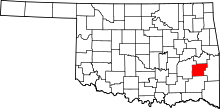 | |
| Towns | ||
| Unincorporated communities | ||
| Footnotes | ‡This populated place also has portions in an adjacent county or counties | |
Municipalities and communities of Le Flore County, Oklahoma, United States | ||
|---|---|---|
| Cities |  | |
| Towns | ||
| CDP | ||
| Other unincorporated communities | ||
| Footnotes | ‡This populated place also has portions in an adjacent county or counties | |