Farrer Park
| Farrer Park | |
|---|---|
| Name transcription(s) | |
| • Chinese | 花拉公园 |
| • Pinyin | Huālā gōngyuán |
| • Malay | Taman Farrer |
| • Tamil | ஃபேரர் பார்க் |
|
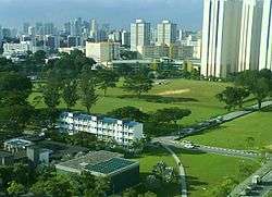
Farrer Park in 2006 | |
| Country |
|

Farrer Park is a subzone of the Rochor planning area in the Central Region of Singapore, bounded by Serangoon Road, Rangoon Road, Race Course Road, Northumberland Road, Tekka Lane and Bukit Timah Road.
It is worth noting that the modern boundary of Farrer Park as stated above is based on the Urban Redevelopment Authority's planning area boundaries which are established for urban planning purpose. The current "Farrer Park" is therefore different from the historic definition of Farrer Park, which is located to its immediate northwest, across Northumberland Road. Historically, the areas called "Farrer Park" are part of present-day Kallang planning area, such as the Farrer Park Fields.
Etymology
Farrer Park and Farrer Road were named after R. J. Farrer (died 1956), who was Municipal Assessor and later President of the Municipal Commissioners in the 1920s. In 1952, there was an abortive attempt to change the name of Farrer Road in order to avoid confusion with Farrer Park, situated in a different location.
History
Serangoon Road Race Course
It was at Farrer Park that Singapore's first racecourse was built and where the island's aviation history began.
The Serangoon Road Race Course was established at Farrer Park in December 1842 and was run by the Singapore Sporting Club. Horse races were held mostly on weekends and attracted a largely European audience. On non-race days, the Racecourse's large turf doubled as a golf course, grazing pasture and rifle range. Staffing the Racecourse were Baweanese settlers from Java in Indonesia. A sizeable Indian community also lived in the Farrer Park area; they were workers and owners of the cattle farms, rattan processing houses and pineapple factories in the vicinity. It was these cattle farms which gave the area its Malay name of Kandang Kerbau, or Buffalo Shed.
The first plane to fly over Singapore was here in March 1911.
On 6 February 1919, Singapore celebrated its centenary and one of the many events that marked the occasion was a grand fair at Farrer Park. The Racecourse grounds were also used as an airstrip.
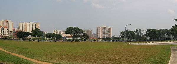
In 1924, the Racecourse was renamed the Singapore Turf Club. It remained at Farrer Park for a further nine years until 1933 when it moved to the Bukit Timah Race Course. Farrer Park was then opened to the public. Playing fields were created and a Sports House was set up in what used to be the grandstand.
Farrer Park remained a favourite sporting venue for decades, with the Sports House becoming the headquarters of the National Sports Promotion Board from 1971 to 1973. Several other sports associations occupied Sports House until 1985 when it was destroyed by a fire.
Farrer Park saw its share of political gatherings during Singapore's turbulent pre- and post-war years. In 1942, immediately following the fall of Singapore to the Japanese, Indian and Malay soldiers were rounded up at Farrer Park and urged by the new rulers to switch allegiance.
In the post-war struggle for independence, political rallies took place at Farrer Park. In 1955, Singapore had its first local political elections for the Legislative Assembly. On 15 August 1955, the People's Action Party campaigned at Farrer Park for self-government.
When Singapore became an independent republic on 9 August 1965, returning military personnel were stationed at Farrer Park until proper barracks were found.
Road names in the area are taken from the names of counties in England. These include Bristol, Carlisle, Cambridge, Dorset, Gloucester, Truro, Hampshire, Norfolk, Owen, Hertford, Northumberland, Oxford, and Kent. One noticeable exception is Owen Road, named after the famous British big game hunter and sportsman, George P. Owen. This trend is also seen in nearby Novena, with names like Essex, Derbyshire, and Shrewsbury, amongst others.
See also
- Farrer Park MRT Station, the North East Line MRT station serving the area.
- Kandang Kerbau Women's and Children's Hospital
- East Asia School of Theology
- City Square Mall (Singapore)
- Little India, Singapore
References
- National Heritage Board (2002), Singapore's 100 Historic Places, Archipelago Press, ISBN 981-4068-23-3
- Victor R Savage, Brenda S A Yeoh (2004), Toponymics - A Study of Singapore Street Names, Eastern University Press, ISBN 981-210-364-3