Boon Lay
| Boon Lay | |
|---|---|
| Name transcription(s) | |
| • Chinese | 文礼 |
| • Pinyin | Wén Lǐ |
| • Hokkien POJ | Bûn Lé |
| • Malay | Boon Lay |
| • Tamil | பூன் லே |
|
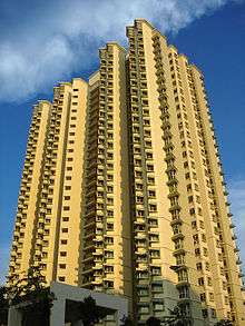
HDB blocks at Boon Lay Place | |
| Country |
|
Boon Lay (Chinese: 文礼, Tamil: பூன் லே), is a neighbourhood located in the town of Jurong West in the West Region of Singapore.[1] Its borders very roughly correspond to the URA subzone of Boon Lay Place, situated within the Jurong West Planning Area.[1] Boon Lay is often confused with the similarly named and less notable planning area of Boon Lay, which is situated further south of the Boon Lay neighbourhood.
The subzone was named after Chew Boon Lay (周文礼), a prominent businessman in the late 19th century and early 20th century who owned the land where the precinct stands. When a requisition of 1.012 km² of land from his estate was done by the war department of the then colonial government of Singapore, it led to the growth of Boon Lay Village in the 1940s, with a population of about 420 in the early 1960s. Boon Lay Place had earthworks begun in 1969 and had their HDB flats built since 1974.
The subzone is a division of West Coast GRC, under the management of West Coast Town Council. The people living there are represented by member of parliament, Patrick Tay.
Neighbouring Areas
 |
Yunnan | Bulim |  | |
| Central | |
Hong Kah | ||
| ||||
| | ||||
| Kian Teck | Chin Bee | Taman Jurong |
Residential Areas
The only private estate in the precinct is 'Summerdale', while the rest consists of estates built by the government.
| Street | Block number |
|---|---|
| Boon Lay Avenue | 185-187, 216A-216B, 217A-217B, 218A-218D |
| Boon Lay Drive | 167-172, 174-179, 180A-180C, 181A-181B, 183A-183D, 188-191, 196A-196B, 197A-197D, 198-206, 257-261, 262-267 |
| Boon Lay Place | 221, 207-209, 210-215 |
- those in italic are HDB's Built-To-Order(BTO) flats which are currently under construction.
Transportation
Roads
The main roads in the precinct are Jalan Boon Lay, Boon Lay Way, Corporation Road and Jurong West Avenue 2, which bounds the precinct and connects it to the rest of the island through linking with the PIE (exits 34 and 36), with minor roads (Boon Lay Avenue, Boon Lay Drive and Boon Lay Place) winding through the various estates in the precinct.
Public Transport
Connection to MRT
The precinct is situated between Boon Lay and Lakeside stations. Connection to both stations is available through feeder bus services 240 and 246 and trunk bus services 30, 154, 157 and 180, depending on direction of travel.
Connection to other areas
- Connection to Nanyang, Gek Poh Ville, Hong Kah, Yuhua, Joo Koon and Clementi is available through trunk bus service 99.
- Connection to Pioneer, Hong Kah, Yuhua, NUH, One-North, Buona Vista, Tanglin Halt, Queenstown and Bukit Merah is available through trunk bus service 198.
- Connection to Pioneer, Bukit Batok, Bukit Timah, Holland Village and the city is available through trunk bus service 174.
- Direct connection to the city is available through express bus service 502.
Night bus services
There are 2 night bus services that run through the precinct during the non-operational hours of the other bus and MRT services, with NR5 operated by SMRT and 5N operated by SBS Transit.
Interstate bus services
In addition to local buses, Malaysian Inter-State Express Buses start off from the former Savoy movie theatre to specific destinations in Malaysia as an alternative to the bus terminals located downtown such as those at Kallang Bahru Bus Terminal and Golden Mile Shopping Centre. Tickets can be bought from ticket agents at Boon Lay Shopping Centre.
Schools
There is 1 primary school (Boon Lay Garden), 1 secondary school (Boon Lay Secondary School), 1 high school (River Valley) and many childcare centres in the precinct.
Other facilities
The town centre is located at Boon Lay Place and is where the residents of Boon Lay bond with each other while meeting their daily needs. It is accessible from all parts of the precinct through feeder bus service 240 and 246 and trunk bus service 99.
There are 2 churches (The Church of Saint Francis of Assisi and Jurong Church of Christ) and 1 temple (Tua Pek Kong Keng Temple) in the precinct and all of them are found in the town centre.
The precinct's community centre (Boon Lay Community Centre) is located at the junction of Boon Lay Place and Boon Lay Avenue, as part of the town centre. It was upgraded from 2010 to 2011.
Boon Lay Shopping Centre
Managed by HDB, this is the shopping centre that caters mainly to the residents of Boon Lay Place. An anchor tenant in this shopping centre is 'NTUC Fairprice'. The shopping centre has been upgraded with new facilities likes elevators and escalators since late 2012.
References
- Victor R Savage, Brenda S A Yeoh (2003), Toponymics - A Study of Singapore Street Names, Eastern Universities Press, ISBN 981-210-205-1
- Ong Chwee Im; Chew Kheng Chuan & Evelyn Chew. (2002). Chew Boon Lay: A Family Traces its History. Singapore: The Compiler. ISBN 981-04-7740-6
- 1 2 "URA 2014 Master Plan boundaries" (PDF). Singapore Department of Statistics (mapped by the Urban Redevelopment Authority).
| Wikimedia Commons has media related to Boon Lay Place. |
External links
- West Coast Town Council
- Boon Lay Place @ sg.pagenation.com
- URA - Planning Area Boundaries @ ura.gov.sg
- NEA - List of Government Markets / Hawker Centres @ nea.gov.sg
- SBS Transit- Upgrading of Boon Lay Bus Interchange
- Boon Lay Constituency Website
