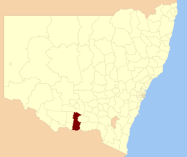
Federation Council, New South Wales
| Federation Council New South Wales | |||||||||||||
|---|---|---|---|---|---|---|---|---|---|---|---|---|---|
 Location in New South Wales | |||||||||||||
| Coordinates | 35°34′S 146°18′E / 35.567°S 146.300°ECoordinates: 35°34′S 146°18′E / 35.567°S 146.300°E | ||||||||||||
| Population | 12,602 (2016 estimate)[1] | ||||||||||||
| • Density | 2.21671/km2 (5.7413/sq mi) | ||||||||||||
| Established | 12 May 2016[1] | ||||||||||||
| Area | 5,685 km2 (2,195.0 sq mi)[1] | ||||||||||||
| Administrator | Michael Eden | ||||||||||||
| Region | Riverina | ||||||||||||
| State electorate(s) | Albury | ||||||||||||
| Federal Division(s) | Farrer | ||||||||||||
| |||||||||||||
The Federation Council is a local government area located in the Riverina region of New South Wales, Australia. This area was formed in 2016 from the merger of the Corowa Shire with its neighbouring Urana Shire.[1]
The council comprises an area of 5,685 square kilometres (2,195 sq mi) and covers the urban areas of Corowa and Mulwala and the surrounding cropping and pastoral region to the north. It is bounded to the south by the Murray River and the state of Victoria. At the time of its establishment the council had an estimated population of 12,602.[1]
The Administrator of the Federation Council is solicitor and former rugby league player Michael Eden, until the elections for councillors to take place on 9 September 2017.
Main towns and villages
In addition to the main urban centres of Corowa and Mulwala, localities in the area include Blighty, Boree Creek, Buraja, Coreen, Daysdale, Hopefield, Howlong, Lowesdale, Morundah, Oaklands, Rand, Rennie, Savernake and Urana.
Council
Once elected, Federation Council will comprise nine Councillors elected proportionally as a single ward. All Councillors are expected to be elected for a fixed four-year term of office with effect from 9 September 2017.[1]
History
The Federation Council was created by the Government of New South Wales as a result of an amalgamation of some local government bodies through a reform program between 2013 and 2016.[2][3] As part of the review, all New South Wales local government authorities were assessed by the NSW Independent Pricing and Regulatory Tribunal on their historical and projected demographic data, financial sustainability, and other measures including their impact on the State's resources. Those council deemed "unfit" were asked to nominate their preferred merger partner in order to achieve economies of scale.[3][4] Corowa and Urana shires both nominated to merge with each other. In addition Lockhart Shire nominated Urana Shire as a preferred merger partner.[4] In December 2015, the Minister for Local Government Paul Toole proposed the amalgamation of all three Councils.[5] All three Councils opposed the proposal and a group of residents in the town of Mulwala in Corowa Shire threatened to secede and join Berrigan Shire if the three-way merger went ahead.[6][7] Corowa Shire put forward the alternate proposal being a merger of Corowa and Urana shires, despite objections from Urana Shire.[8] The Minister accepted the Corowa and Urana merger proposal and the Federation Council was proclaimed on 12 May 2016.[1]
See also
References
- 1 2 3 4 5 6 7 "Federation Council". Stronger Councils. Government of New South Wales. 12 May 2016. Retrieved 13 May 2016.
- ↑ Sansom, Graham; Munro, Jude; Inglis, Glenn (25 October 2013). "Revitalising Local Government: Final Report" (PDF). Independent Local Government Review Panel. Government of New South Wales. Retrieved 11 January 2015.
- 1 2 Johnston, David (20 October 2015). "Corowa and Urana shires both ruled not fit for future by IPART". Border Mail. Retrieved 22 May 2016.
- 1 2 Willett, Rachael (23 March 2016). "Urana digs in and says 'no' to voluntary merger". mmg.com.au. Retrieved 22 May 2016.
- ↑ Johnston, David (18 December 2015). "Lockhart joins Corowa and Urana in merger". Border Mail. Retrieved 22 May 2016.
- ↑ Muir, Robert (19 January 2016). "Yes Minister…..but No, Minister". Corowa Free Press. Retrieved 22 May 2016.
- ↑ Willett, Rachael (19 January 2016). "Mulwala on the move?". Yarrawonga Chronicle. Retrieved 22 May 2016.
- ↑ Johnston, David (11 March 2016). "Urana Shire prefers to be standalone rather than taken over by Corowa Shire". Border Mail. Retrieved 22 May 2016.
External links
- "Local Government Area Boundary: Federation Council" (PDF) (Map). Land & Property Information. Government of New South Wales. 19 April 2016.