Widgiewa, New South Wales
| Widgiewa New South Wales | |
|---|---|
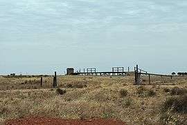 Abandoned rail siding at Widgiewa | |
|
Widgiewa | |
| Coordinates | 35°02′39″S 146°11′50″E / 35.04417°S 146.19722°ECoordinates: 35°02′39″S 146°11′50″E / 35.04417°S 146.19722°E |
| Postcode(s) | 2700 |
| Elevation | 112 m (367 ft) |
| Location | |
| LGA(s) | Federation Council |
| County | Urana |
| State electorate(s) | Albury |
| Federal Division(s) | Farrer |
Widgiewa is a small community in the central part of the Riverina. It is situated by road, about 9 kilometres (5.6 mi) south west from Morundah and 25 kilometres (16 mi) north east from Bundure.
The place name Widgiewa is derived from the local Aboriginal word meaning "What do you want?".[1]
Widgiewa was a station on the Tocumwal railway line. The station opened on 16 September 1884 and closed on 4 May 1975.[2]
Widgiewa Post Office opened on 15 March 1912 and closed in 1970.[3]
References
- ↑ "Widgiewa". Geographical Names Register (GNR) of NSW. Geographical Names Board of New South Wales. Retrieved 11 August 2013.
- ↑ Bozier, Rolfe; et al. "Tocumwal Branch". NSWrail.net. Retrieved 2013-03-18.
- ↑ Premier Postal History, Post Office List, retrieved 2009-06-11
External links
![]() Media related to Widgiewa, New South Wales at Wikimedia Commons
Media related to Widgiewa, New South Wales at Wikimedia Commons
This article is issued from Wikipedia - version of the 8/20/2016. The text is available under the Creative Commons Attribution/Share Alike but additional terms may apply for the media files.