Fence Lake, New Mexico
| Fence Lake, New Mexico | |
|---|---|
| Census-designated place | |
|
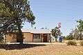
In front of the old school building | |
 Fence Lake | |
| Coordinates: 34°39′12″N 108°40′39″W / 34.65333°N 108.67750°WCoordinates: 34°39′12″N 108°40′39″W / 34.65333°N 108.67750°W | |
| Country | United States |
| State | New Mexico |
| County | Cibola |
| Area | |
| • Total | 16.9 sq mi (43.8 km2) |
| • Land | 16.9 sq mi (43.8 km2) |
| • Water | 0.0 sq mi (0.0 km2) |
| Elevation | 7,070 ft (2,150 m) |
| Population (2010) | |
| • Total | 42 |
| • Density | 3/sq mi (1.0/km2) |
| Time zone | Mountain (MST) (UTC-7) |
| • Summer (DST) | MDT (UTC-6) |
| ZIP code | 87315 |
| Area code(s) | 505 |
| FIPS code | 35-26010 |
| GNIS feature ID | 0898775 |
Fence Lake is a census-designated place located in southwestern Cibola County, New Mexico, United States. As of the 2010 census it had a population of 42.[1] The area is largely ranchland, and there are few businesses there. According to local residents, the name was derived from the original settlers having to fence off a pond formed in a natural depression that was in the area, to keep animals from contaminating the water source.
Demographics
As of the 2010 census, the population of the Fence Lake CDP was 42, consisting of 23 households, of which 11 were families. Females were 54.8% of the population. The racial make-up of the CDP was 26.2% Native American, 71.4% White, and 2.4% Asian. Hispanic or Latino of any race was 4.8% of the population.[2]
Geography
Fence Lake is located on New Mexico State Road 36, 33 miles (53 km) south of NM 53. It is 63 miles (101 km) south of Gallup and 40 miles (64 km) northwest of Quemado. Its coordinates are 34°39′12″N 108°40′36″W / 34.65333°N 108.67667°W. The Zuni Reservation is to the north and west.
The original Fence Lake location is shown on USGS topographic maps of the area as being about 3 miles (5 km) southeast of the center of town.
Average rainfall, inches: January 1.1; February 1.1; March 1.2; April 0.7; May 0.7; June 0.5; July 2.4; August 2.6; September 1.6; October 0.9; November 0.9; December 1.0; Year 14.8[3]
Post office
There is a post office located in Fence Lake, with the zip code 87315.
Fence Lake activities
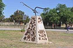
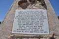
Fence Lake holds an old timers' reunion every other year on odd years, and has done so since the last Saturday in July 1961. Over the years, it has grown to a gathering in even years, also, with fiddle contests, jam sessions, and dances in the school building. Barbecue and pot luck meals are served. People attend sometimes from all over the globe.
Also the community turns out for the annual Fourth of July parade, including the town fire truck and various other participants.
-

The stage in the old school house
-

The start of the parade
-

The chuck wagon
-
Fine words by local Manion Long
-

The lake bed today southeast of the village
-
Post office in 2009
Aggressive Christianity Missionary Training Corps
Shim Ra Na Ekklisia (also called Miracle River)[4] is located near Fence Lake. It is a small community of Christians about 10 miles (16 km) to the east of the town.
References
- ↑ "Geographic Identifiers: 2010 Demographic Profile Data (G001): Fence Lake CDP, New Mexico". U.S. Census Bureau, American Factfinder. Retrieved October 20, 2014.
- ↑ "Profile of General Population and Housing Characteristics: 2010 Demographic Profile Data (DP-1): Fence Lake CDP, New Mexico". U.S. Census Bureau, American Factfinder. Retrieved October 20, 2014.
- ↑ FENCE LAKE, Cibola (formerly Valencia County) data derived from NCDC Cooperative Stations. 25 complete years between 1933 and 1995
- ↑ Aggressive Christianity-Home of Shim Ra Na Holy Tribal Nation
External links
Municipalities and communities of Cibola County, New Mexico, United States | ||
|---|---|---|
| City | 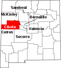 | |
| Village | ||
| CDPs | ||
| Unincorporated communities | ||
| Indian reservations | ||
| Footnotes | ‡This populated place also has portions in an adjacent county or counties | |