Seboyeta, New Mexico
| Seboyeta, New Mexico | |
|---|---|
| Census-designated place | |
|
Exterior view of a church at Cibolleta, New Mexico, ca.1898 | |
 Seboyeta | |
| Coordinates: 35°12′04″N 107°23′21″W / 35.20111°N 107.38917°WCoordinates: 35°12′04″N 107°23′21″W / 35.20111°N 107.38917°W | |
| Country | United States |
| State | New Mexico |
| County | Cibola |
| Area[1] | |
| • Total | 11.518 sq mi (29.83 km2) |
| • Land | 11.509 sq mi (29.81 km2) |
| • Water | 0.009 sq mi (0.02 km2) |
| Elevation | 6,394 ft (1,949 m) |
| Population (2010)[2] | |
| • Total | 179 |
| • Density | 16/sq mi (6.0/km2) |
| Time zone | Mountain (MST) (UTC-7) |
| • Summer (DST) | MDT (UTC-6) |
| ZIP code | 87014[3] |
| Area code(s) | 505 |
| GNIS feature ID | 923688[4] |
.jpg)
Seboyeta is a census-designated place in Cibola County, New Mexico, United States. Its population was 179 as of the 2010 census. Seboyeta had a post office from February 5, 1885, to January 7, 1995.[5] The community was established in 1749.[4]
References
- ↑ "US Gazetteer files: 2010, 2000, and 1990". United States Census Bureau. 2011-02-12. Retrieved 2011-04-23.
- ↑ "American FactFinder". United States Census Bureau. Retrieved 2011-05-14.
- ↑ United States Postal Service (2012). "USPS - Look Up a ZIP Code". Retrieved 2012-02-15.
- 1 2 "Seboyeta". Geographic Names Information System. United States Geological Survey.
- ↑ "Postmaster Finder - Post Offices by ZIP Code". United States Postal Service. Retrieved August 10, 2013.
Municipalities and communities of Cibola County, New Mexico, United States | ||
|---|---|---|
| City | 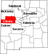 | |
| Village | ||
| CDPs | ||
| Unincorporated communities | ||
| Indian reservations |
| |
| Footnotes | ‡This populated place also has portions in an adjacent county or counties | |
This article is issued from Wikipedia - version of the 10/21/2014. The text is available under the Creative Commons Attribution/Share Alike but additional terms may apply for the media files.