Fontenoy-sur-Moselle
| Fontenoy-sur-Moselle | |
|---|---|
 Fontenoy-sur-Moselle | |
|
Location within Grand Est region  Fontenoy-sur-Moselle | |
| Coordinates: 48°42′43″N 5°58′55″E / 48.7119°N 5.9819°ECoordinates: 48°42′43″N 5°58′55″E / 48.7119°N 5.9819°E | |
| Country | France |
| Region | Grand Est |
| Department | Meurthe-et-Moselle |
| Arrondissement | Arrondissement of Toul |
| Canton | Canton of Toul-Nord |
| Intercommunality | Communauté de communes de la Hazelle |
| Government | |
| • Mayor (2008–2014) | Jeanne Bluette |
| Area1 | 5.54 km2 (2.14 sq mi) |
| Population (1999)2 | 195 |
| • Density | 35/km2 (91/sq mi) |
| Time zone | CET (UTC+1) |
| • Summer (DST) | CEST (UTC+2) |
| INSEE/Postal code | 54202 / 54840 |
| Elevation |
192–264 m (630–866 ft) (avg. 205 m or 673 ft) |
|
1 French Land Register data, which excludes lakes, ponds, glaciers > 1 km² (0.386 sq mi or 247 acres) and river estuaries. 2 Population without double counting: residents of multiple communes (e.g., students and military personnel) only counted once. | |
Fontenoy-sur-Moselle is a commune in the Meurthe-et-Moselle department in north-eastern France.
See also
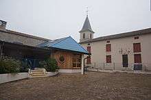
City hall and church.
| Wikimedia Commons has media related to Fontenoy-sur-Moselle. |
This article is issued from Wikipedia - version of the 2/11/2016. The text is available under the Creative Commons Attribution/Share Alike but additional terms may apply for the media files.