Gorcy
| Gorcy | ||
|---|---|---|
|
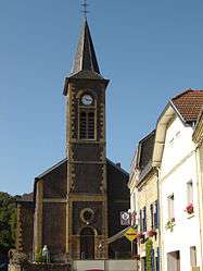
Gorcy church | ||
| ||
 Gorcy | ||
|
Location within Grand Est region  Gorcy | ||
| Coordinates: 49°32′08″N 5°41′07″E / 49.5356°N 5.6853°ECoordinates: 49°32′08″N 5°41′07″E / 49.5356°N 5.6853°E | ||
| Country | France | |
| Region | Grand Est | |
| Department | Meurthe-et-Moselle | |
| Arrondissement | Briey | |
| Canton | Mont-Saint-Martin | |
| Intercommunality | Communauté de communes de l'agglomération de Longwy | |
| Government | ||
| • Mayor (2008–2014) | Bernard Labbe | |
| Area1 | 4.1 km2 (1.6 sq mi) | |
| Population (2006)2 | 2,333 | |
| • Density | 570/km2 (1,500/sq mi) | |
| Time zone | CET (UTC+1) | |
| • Summer (DST) | CEST (UTC+2) | |
| INSEE/Postal code | 54234 / 54730 | |
| Elevation | 235–385 m (771–1,263 ft) | |
|
1 French Land Register data, which excludes lakes, ponds, glaciers > 1 km² (0.386 sq mi or 247 acres) and river estuaries. 2 Population without double counting: residents of multiple communes (e.g., students and military personnel) only counted once. | ||

Gorcy is a French commune, located in the department of Meurthe-et-Moselle and the Grand Est region. This village on the north of the Meurthe-et-Moselle is next to the Belgian frontier, and about 10 km from Longwy, main city of the "Pays-Haut".
Its inhabitants are named Gorcéens and Gorcéennes.
History
- Village of the old Barrois province.
- Cussigny was attached with Gorcy in 1810.
Steel industry
In 1832, Jean Joseph Labbé built a first blast furnace in Gorcy, on the Parivaux. From 1846 to 1848, two new blast furnaces were built. The factory, partially destroyed during the war of 1870, is rebuilt and set in rights. In 1877, the two blast furnaces were removed and replaced by two other more powerful. Before the World War I, the Société métallurgique de Gorcy still exploits two blast furnaces which will disappear in the 30's.
| Historical population | ||
|---|---|---|
| Year | Pop. | ±% |
| 1793 | 129 | — |
| 1800 | 115 | −10.9% |
| 1806 | 121 | +5.2% |
| 1821 | 237 | +95.9% |
| 1836 | 408 | +72.2% |
| 1841 | 423 | +3.7% |
| 1861 | 668 | +57.9% |
| 1866 | 657 | −1.6% |
| 1872 | 654 | −0.5% |
| 1876 | 799 | +22.2% |
| 1881 | 1,199 | +50.1% |
| 1886 | 861 | −28.2% |
| 1891 | 943 | +9.5% |
| 1896 | 1,053 | +11.7% |
| 1901 | 1,070 | +1.6% |
| 1906 | 1,124 | +5.0% |
| 1911 | 1,512 | +34.5% |
| 1921 | 1,250 | −17.3% |
| 1926 | 1,520 | +21.6% |
| 1931 | 1,516 | −0.3% |
| 1936 | 1,350 | −10.9% |
| 1946 | 1,100 | −18.5% |
| 1954 | 1,462 | +32.9% |
| 1962 | 2,228 | +52.4% |
| 1968 | 2,364 | +6.1% |
| 1975 | 2,686 | +13.6% |
| 1982 | 2,473 | −7.9% |
| 1990 | 2,168 | −12.3% |
| 1999 | 2,130 | −1.8% |
| 2006 | 2,333 | +9.5% |
| 1962 to 1999: Official population without duplicates Source: Cassini-Ldh-EHESS[1] et Insee 2009.[2] | ||
Places and monuments
- Industrialist's castle known as Château du Parivaux (Parivaux' Castle), built from 1898 to 1900, for Georges Rolland, husband of Marcelle Labbé, the "château du bas" were in this time inhabited by his brother-in-law Paul ; bombarded in 1940, it was deleted in 1967, because there was too much renovation to do.
- Industrialist's castle known as Château bas, built from 1880 to 1883, for Jean-Joseph Labbé, founder of the Forges de Gorcy in 1832 ; gravely damaged by a bombardment in 1940, it was delted in 1955, because there was too much renovations to do.
- Château de la Martinière, built in the start of the 17th century, maybe in 1603, in accordance with a date today disappeared, for Claude des Bernards, founder of the branch of Des Bernards of Gorcy ; he came in the De la Martinière's family with a marriage in 1725, it was renovated in 1740, date carried by the pedestrian door of the main part ; the moat surrounding the castale was filled in in 1855 and the baskets of fruit putted in the columns of the old enter gate come from the old Château du Pulventeux in Longwy-Haut.
- Castle known as Château des Gorcy . Strong house of the Gorcys maybe built in the 16th century, very damaged in 1671 by the troops of the marshal De Créqui, renovated in the 18th century, extended toward south in the 19th century, and became a property of the Labbé's family. It was given to the commune and completely makeovered in 1979. It's actually the town hall.
- The military cemetery, where the Maréchal Foch's son is buried. It's near to the frontier. In this cemetery, is also buried René Viviani's son, Council president from 1914 to 1918
- The Cussignère marsh, a wood bridge cross it and link France to Belgium.
- The monument to the ruthlesses
- The walk along of the river Coulmy.
Religious building
- Parish church Saint-Jean-Baptiste ; the parish depended on the Musson's church until 1785 (actually in Belgium); from this date, the exercise of the cult is in the cadatsral chapel of M. Maillard de la Martinière ; became too little and too damaged, it was replaced in 1837 by a church, built with the Bauchet's plan, architect in Briey; it is extended and makeovered in 1896 with the L.Lanternier's plan, architect in Nancy. It's blessed in 1898.
Manifestations
- Fête de la Cussignère (latest October week-end) : international eco-fai of biological products ;
- Annual tournament of soccer.
See also
References
External links
| Wikimedia Commons has media related to Gorcy. |