Longuyon
| Longuyon | ||
|---|---|---|
|
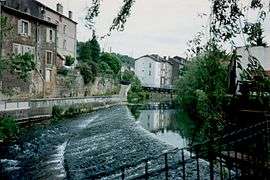
Crusnes River in Longuyon | ||
| ||
 Longuyon | ||
|
Location within Grand Est region  Longuyon | ||
| Coordinates: 49°26′52″N 5°36′05″E / 49.4478°N 5.6014°ECoordinates: 49°26′52″N 5°36′05″E / 49.4478°N 5.6014°E | ||
| Country | France | |
| Region | Grand Est | |
| Department | Meurthe-et-Moselle | |
| Arrondissement | Briey | |
| Canton | Longuyon | |
| Government | ||
| • Mayor (2014-2020) | Jean-Pierre Jacque | |
| Area1 | 29.7 km2 (11.5 sq mi) | |
| Population (2011)2 | 5,559 | |
| • Density | 190/km2 (480/sq mi) | |
| Time zone | CET (UTC+1) | |
| • Summer (DST) | CEST (UTC+2) | |
| INSEE/Postal code | 54322 / 54260 | |
| Elevation |
203–389 m (666–1,276 ft) (avg. 218 m or 715 ft) | |
| Website | longuyon.fr | |
|
1 French Land Register data, which excludes lakes, ponds, glaciers > 1 km² (0.386 sq mi or 247 acres) and river estuaries. 2 Population without double counting: residents of multiple communes (e.g., students and military personnel) only counted once. | ||


Canadian totem pole in Longuyon
Longuyon is a commune in the Meurthe-et-Moselle department in north-eastern France.
The apartment blocks on the southwestern edge of town, still called "La Cité Canadienne", were home to Royal Canadian Air Force staff and their families in the 1950s and 1960s, when the RCAF had an airbase at nearby Marville. The street names still carry the names Toronto, Montreal, etc., and a totem pole was erected as a monument to the Canadian presence in Longuyon.
See also
| Wikimedia Commons has media related to Longuyon. |
This article is issued from Wikipedia - version of the 2/18/2016. The text is available under the Creative Commons Attribution/Share Alike but additional terms may apply for the media files.