Fort Defiance (Ohio)
| Fort Defiance | |
|---|---|
| Part of the Northwest Territory of the United States | |
| present day Defiance, Ohio | |
|
Fort Defiance[1] | |
| Site history | |
| Built | 1794 |
| Battles/wars | Northwest Indian War, Tecumseh's War, War of 1812 |
| Garrison information | |
| Past commanders | Anthony Wayne |
| Occupants | United States troops |
|
Fort Defiance Park | |
|
Overview of the fort site | |
  | |
| Location | Fort St., Defiance, Ohio |
|---|---|
| Coordinates | 41°17′15″N 84°21′25″W / 41.28750°N 84.35694°WCoordinates: 41°17′15″N 84°21′25″W / 41.28750°N 84.35694°W |
| Area | 1.3 acres (0.53 ha) |
| Built | 1794 |
| Architect | Major Henry Burbeck |
| NRHP Reference # | 80002989[2] |
| Added to NRHP | June 23, 1980 |
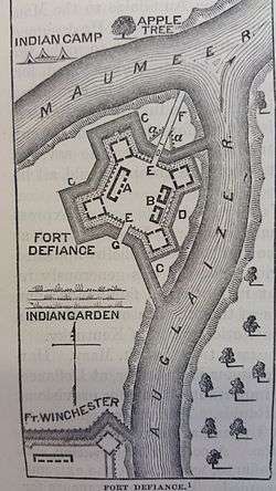
Fort Defiance was ordered built by General "Mad" Anthony Wayne in August 1794 at the confluence of the Auglaize and Maumee rivers. It was the last of a line of defenses constructed by American forces in the campaign leading to the Northwest Indian War's Battle of Fallen Timbers on August 20, 1794.
Work began on August 9, 1794 and was completed by August 17. The name was derived from a declaration by Charles Scott, who was leading a band of Kentucky militiamen in support of Wayne, that: "I defy the English, Indians, and all the devils of hell to take it."[3] The post was considered one of the strongest fortifications built in that period.
Following the Battle of Fallen Timbers, Wayne used Fort Defiance as his base of operations and ordered the destruction of all Native American villages and their crops within a 50-mile (80 km) radius of the fort. Under terms of the Treaty of Greenville, signed on August 3, 1795, the native nations ceded six square miles around the fort and allowed the Americans to maintain a trading post there, even though it was within the area of land defined by the "Greenville Treaty Line", beyond which Americans had agreed not to settle.
Until the War of 1812, Fort Defiance was one of the westernmost outposts in Ohio. William Henry Harrison used it as one base for his attacks against Native Americans during Tecumseh's War, and the fort played a role in the War of 1812 as well.
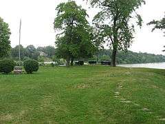
The city of Defiance, Ohio, was founded at the fort's location. In 1904, the site of the fort was chosen for the Defiance Public Library.
Fort Defiance served as a reference point for defining the boundary line of land cession in the Treaty of Detroit in 1807. This north-south line would be used again as the Michigan Meridian in the survey of lands in Michigan.
Today, a park occupies the site of the fort, which was added to the National Register of Historic Places in 1980.[2]
References
- ↑ Lossing, Benson (1868). The Pictorial Field-Book of the War of 1812. Harper & Brothers, Publishers. p. 330.
- 1 2 National Park Service (2009-03-13). "National Register Information System". National Register of Historic Places. National Park Service.
- ↑ Nelson, p. 246
- Nelson, Paul D. (1986). "General Charles Scott, the Kentucky Mounted Volunteers, and the Northwest Indian Wars, 1784–1794". Journal of the Early Republic. 6 (3): 219–251. doi:10.2307/3122915. JSTOR 3122915.
External links
- Ohio History Central
- History of Fort Defiance
- Fort Defiance in the War of 1812
- An Ohio History Travelogue
- Photos and visiting information
- U.S. Geological Survey Geographic Names Information System: Fort Defiance (Ohio)
| Topics | |
|---|---|
| Lists by states |
|
| Lists by insular areas | |
| Lists by associated states | |
| Other areas | |
| |