Gauḍa (region)
Part of a series on the |
|---|
| History of Bengal |
 |
| Ancient geopolitical units |
| Ancient and classical dynasties |
| Medieval and Early Modern periods |
| European colonisation |
| Bangladesh |
| Indian Bengal |
| Related |
Gauda (Bengali: গৌড়), was a territory located in Bengal in ancient and medieval times,[1][2] as part of the Gauda Kingdom.
Location and extent
The Arthashastra of Chanakya (around 350–-283 BC) refers to it along with Vanga, Pundra and Kamarupa. This geographical idea continues with some of the ancient texts.[2] Gauda and Vanga are sometimes used side by side.[1]
Shashanka, the first important king of ancient Bengal who is believed to have ruled between 590 AD to 625 AD, had his capital at Karnasubarna, 9.6 kilometres (6.0 mi) south-west of Baharampur, headquarters of Murshidabad district.[1] The Chinese monk, Xuanzang (Hiuen Tsang) travelled from the country of Karnasubarna to a region in Orissa ruled by Shashanka.[2] There is mention of Pundravardhana being part of Gauda in certain ancient records.[3]
Evidence seems to be discrepant regarding links of Gauda with the Rarh region. While Krishna Mishra (eleventh or twelfth century AD), in his Prabodha-chandrodaya, mentions that Gauda rashtra includes Rarh (or Rarhpuri) and Bhurishreshthika, identified with Bhurshut, in Hooghly and Howrah districts, but the Managoli inscription of the Yadava king Jaitugi I distinguishes Lala (Rarh) from Gaula (Gauda).[1]
According to Jain writers of the thirteenth and fourteenth centuries, Gauda included Lakshmanavati in present-day Malda district.[1]
The Pala emperors were referred to as Vangapati (Lord of Vanga) and Gaudesvara (Lord of Gauda). Sena kings also called themselves Gaudesvara. From then Gauda and Vanga seem to be interchangeable names for whole of Bengal.[1]
In the early Muslim period the name Gauda came to be applied to Lakhanavati in Malda district.[1]
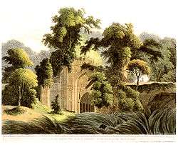
Gour, ruined city
Gaur/Gour (Bengali: গৌড়), as it is spelled mostly in modern times, refers to Lakhnauti the ruined city located on the India-Bangladesh border. Most of the former citadel is located in present-day the Malda district of West Bengal, India, while a smaller part is located in Nawabganj District of Bangladesh. This city was on the east bank of the Ganges river, 40 kilometers (25 mi) downstream from Rajmahal. Howeverver, the current course of the Ganges is far away from the ruins.
References
- 1 2 3 4 5 6 7 Majumdar, Dr. R.C., History of Ancient Bengal, first published 1971, reprint 2005, pp. 5-6, Tulshi Prakashani, Kolkata, ISBN 81-89118-01-3.
- 1 2 3 Ghosh, Suchandra. "Gauda". Banglapedia. Asiatic Society of Bangladesh. Retrieved 2009-08-22.
- ↑ Bandopadhyay, Rakhaldas, Bangalar Itihas, (Bengali), first published 1928, revised edition 1971, vol I, p 101, Nababharat Publishers, 72 Mahatma Gandhi Road, Kolkata.