Gennep
| Gennep | |||
|---|---|---|---|
| Municipality | |||
|
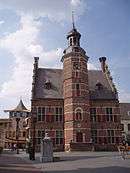
View over Gennep | |||
| |||
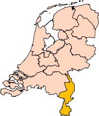
.svg.png) Location in Limburg | |||
| Coordinates: 51°42′N 5°58′E / 51.700°N 5.967°ECoordinates: 51°42′N 5°58′E / 51.700°N 5.967°E | |||
| Country | Netherlands | ||
| Province | Limburg | ||
| Government[1] | |||
| • Body | Municipal council | ||
| • Mayor | Peter de Koning (VVD) | ||
| Area[2] | |||
| • Total | 50.42 km2 (19.47 sq mi) | ||
| • Land | 47.71 km2 (18.42 sq mi) | ||
| • Water | 2.71 km2 (1.05 sq mi) | ||
| Elevation[3] | 13 m (43 ft) | ||
| Population (May 2014)[4] | |||
| • Total | 17,277 | ||
| • Density | 362/km2 (940/sq mi) | ||
| Demonym(s) | Gennepenaar, Genneper | ||
| Time zone | CET (UTC+1) | ||
| • Summer (DST) | CEST (UTC+2) | ||
| Postcode | 6590–6599 | ||
| Area code | 0485 | ||
| Website |
www | ||


Gennep (![]() pronunciation ) is a municipality and a city in upper southeastern Netherlands. It lies in the northern part of the province of Limburg. Furthermore, it lies on the right bank of the Meuse river, and south of the forest of the Klever Reichswald. The municipality of Gennep has 17,277 inhabitants (2014).
pronunciation ) is a municipality and a city in upper southeastern Netherlands. It lies in the northern part of the province of Limburg. Furthermore, it lies on the right bank of the Meuse river, and south of the forest of the Klever Reichswald. The municipality of Gennep has 17,277 inhabitants (2014).
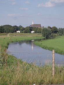
The Niers river flows into the Meuse in Gennep.
Population centres
Aaldonk, Dam, De Looi, Diekendaal, Gennep, Heijen, Hekkens, Milsbeek, Ottersum, Smele, Ven-Zelderheide, and Zelder.
Topography

Dutch topographic map of the municipality of Gennep, June 2015
The city of Gennep
Gennep was the title of a comital family, known descendants of which are the famous Saint Norbert of Gennep and William of Gennep, Archbishop-Elector of Cologne.
Gennep probably received city rights in 1371. However, it remains unclear whether these city rights have really been assigned to Gennep, as the supposed documents burned during a fire in the townhall of Gennep at the end of the 16th century. Gennep lies about 18 kilometres (11 miles) southeast of Nijmegen.
In 2001, Gennep had 8306 inhabitants. The built-up area of the town was 2.11 square kilometres (0.81 sq mi), and contained 3124 residences.[5]
International relations
Twin towns — Sister cities
Gennep is twinned with:
References
- ↑ "Burgemeester Dhr. P.J.H.M. De Koning" [Mayor Mr. P.J.H.M. De Koning] (in Dutch). Gemeente Gennep. Retrieved 16 October 2013.
- ↑ "Kerncijfers wijken en buurten" [Key figures for neighbourhoods]. CBS Statline (in Dutch). CBS. 2 July 2013. Retrieved 12 March 2014.
- ↑ "Postcodetool for 6591CP". Actueel Hoogtebestand Nederland (in Dutch). Het Waterschapshuis. Retrieved 16 October 2013.
- ↑ "Bevolkingsontwikkeling; regio per maand" [Population growth; regions per month]. CBS Statline (in Dutch). CBS. 26 June 2014. Retrieved 24 July 2014.
- ↑ Statistics Netherlands (CBS), Bevolkingskernen in Nederland 2001 . Statistics are for the continuous built-up area.
External links
 Media related to Gennep at Wikimedia Commons
- Official website
 |
Mook en Middelaar | Berg en Dal (GE), Kranenburg (DE-NW) | | |
| Cuijk (NB) / Meuse Boxmeer (NB) / Meuse |
|
Goch (DE-NW) | ||
| ||||
| | ||||
| Bergen |