Gulpen-Wittem
| Gulpen-Wittem Gullepe-Wittem | |||
|---|---|---|---|
| Municipality | |||
|
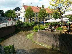
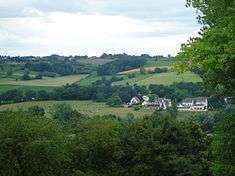
The Gulp River through Gulpen | |||
| |||
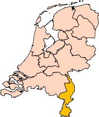
.svg.png) Location in Limburg | |||
| Coordinates: 50°49′N 5°53′E / 50.817°N 5.883°ECoordinates: 50°49′N 5°53′E / 50.817°N 5.883°E | |||
| Country | Netherlands | ||
| Province | Limburg | ||
| Established | 1 January 1999[1] | ||
| Government[2] | |||
| • Body | Municipal council | ||
| • Mayor | Bas van den Tillaar (CDA) | ||
| Area[3] | |||
| • Total | 73.35 km2 (28.32 sq mi) | ||
| • Land | 73.16 km2 (28.25 sq mi) | ||
| • Water | 0.19 km2 (0.07 sq mi) | ||
| Elevation[4] | 95 m (312 ft) | ||
| Population (May 2014)[5] | |||
| • Total | 14,431 | ||
| • Density | 197/km2 (510/sq mi) | ||
| Time zone | CET (UTC+1) | ||
| • Summer (DST) | CEST (UTC+2) | ||
| Postcode | 6270–6289, 6320–6321 | ||
| Area code | 043 | ||
| Website |
www | ||

Gulpen-Wittem (![]() pronunciation ) (Limburgish: Gullepe-Wittem) is a municipality in the southeastern Netherlands (in the province of Limburg) with 14,431 inhabitants as of 2014.
pronunciation ) (Limburgish: Gullepe-Wittem) is a municipality in the southeastern Netherlands (in the province of Limburg) with 14,431 inhabitants as of 2014.
Gulpen-Wittem came into being after the merger of the municipalities Gulpen and Wittem. This took place after a request of both municipalities. At the time of the merger, both municipalities had about 8000 inhabitants, although Wittem was bigger than Gulpen. The town hall was situated in Gulpen, and has kept its function as town hall in the new municipality. The former town hall of Wittem was situated in a manor house in Mechelen since 1986, which is now being used as a "nursing hostel".
The municipality is very rural, with a lot of castles, half-timbered houses and old monumental farms. Yearly, Gulpen-Wittem attracts many tourists from the entire country because of its relatively sloping landscape, especially during the summer.
Population centres
|
|
|
|
Topography
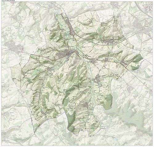
Dutch Topographic map of the municipality of Gulpen-Wittem, June 2015
Economy
Apart from beer brewing ("Gulpener" (at Gulpen) and "Brand" (at Wijlre)), vinager production ("Gulpener") and agriculture, tourism is essential aspect of economical activity in this municipality. Especcially Slenaken is a distinct tourist site.
Gallery
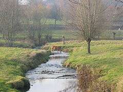 The river Gulp near Slenaken |
 Hilly landscape near Slenaken |
References
- ↑ "Gemeentelijke indeling op 1 januari 1999" [Municipal divisions on 1 January 1999]. cbs.nl (in Dutch). CBS. Retrieved 17 October 2013.
- ↑ "College van Burgemeester en Wethouders" [Board of mayor and aldermen] (in Dutch). Gemeente Gulpen-Wittem. Retrieved 17 October 2013.
- ↑ "Kerncijfers wijken en buurten" [Key figures for neighbourhoods]. CBS Statline (in Dutch). CBS. 2 July 2013. Retrieved 12 March 2014.
- ↑ "Postcodetool for 6271BG". Actueel Hoogtebestand Nederland (in Dutch). Het Waterschapshuis. Retrieved 17 October 2013.
- ↑ "Bevolkingsontwikkeling; regio per maand" [Population growth; regions per month]. CBS Statline (in Dutch). CBS. 26 June 2014. Retrieved 24 July 2014.
External links
 Media related to Gulpen-Wittem at Wikimedia Commons
- Official website
 |
Valkenburg aan de Geul | Voerendaal | Simpelveld | |
| Eijsden-Margraten | |
Aachen (DE-NW) Vaals | ||
| ||||
| | ||||
| Voeren (BE-VLI) | Plombières (BE-WLG) |