Heerlen
| Heerlen Heële | |||
|---|---|---|---|
| City and Municipality | |||
|
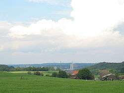
Heerlen skyline as seen from the nearby village of Vrouweheide | |||
| |||
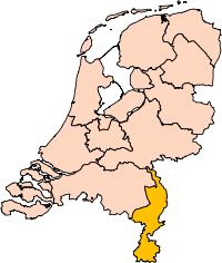
.svg.png) Location in Limburg | |||
| Coordinates: 50°53′N 5°59′E / 50.883°N 5.983°ECoordinates: 50°53′N 5°59′E / 50.883°N 5.983°E | |||
| Country | Netherlands | ||
| Province | Limburg | ||
| Government[1] | |||
| • Body | Municipal council | ||
| • Mayor | Ralf Krewinkel (PvdA) | ||
| Area[2] | |||
| • Municipality | 45.53 km2 (17.58 sq mi) | ||
| • Land | 45.02 km2 (17.38 sq mi) | ||
| • Water | 0.51 km2 (0.20 sq mi) | ||
| Elevation[3] | 113 m (371 ft) | ||
| Population (Municipality, May 2014; Urban and Metro, May 2014)[4][5] | |||
| • Municipality | 88,022 | ||
| • Density | 1,955/km2 (5,060/sq mi) | ||
| • Urban | 200,957 | ||
| • Metro | 247,731 | ||
| Demonym(s) | Heerlenaar | ||
| Time zone | CET (UTC+1) | ||
| • Summer (DST) | CEST (UTC+2) | ||
| Postcode | 6400–6433 | ||
| Area code | 045 | ||
| Website |
www | ||


Heerlen (Dutch pronunciation: [ˈɦeːrlə(n)]; Limburgish: Heële) is a city and a municipality in the southeast of the Netherlands. It is the fourth largest municipality in the province of Limburg.
Heerlen forms part of Parkstad Limburg, formerly known as Oostelijke Mijnstreek (Eastern Coal Mining District), an agglomeration with about 220,000 inhabitants.
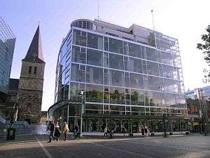
After its early Roman beginnings and a modest medieval period, Heerlen became a centre for the coal mining industry in the Netherlands in the late 19th century. In the 20th century, architect Frits Peutz played a major role in shaping the city as we know it today. His most famous design, and a distinctive building in the city centre, is the so-called Glaspaleis (Glass Palace), listed as one of the world's thousand most architecturally important buildings of the 20th century.
History
In 1997, a habitation from the Michelsberg culture (4400 - 3500 BC) was excavated at the Schelsberg, near Heerlen. Archeological finds from this period are rare in the Netherlands. The site is unique in the Netherlands, as it is the first excavated site with ditches and earth walls (earthworks).[6]
Even with these proofs of early habitation, the history of Heerlen properly starts with the arrival of the Romans. They founded a military settlement, named Coriovallum on the crossroad of two main roads: Boulogne sur Mer - Cologne and Xanten - Aachen - Trier. In Heerlen and its surroundings a lot of evidence of Roman life has been excavated, especially Roman villas (country estates). The most notable archeological excavation from Roman times is the Thermae complex in the centre of Heerlen, a Roman bathhouse, discovered in 1940. In the Netherlands only a few of these have been found. It is a clear indication that Coriovallum/Heerlen was of some importance. A museum has been built over the Thermae and opened in 1977. The Thermenmuseum also houses other Roman finds from the area.
Like many other Roman settlements in the Netherlands, Coriovallum was probably abandoned after the 3rd/4th century Roman retreat. Very little is known about Heerlen's history until the 10th century, when agricultural development continues once again in these parts of Europe. Farmhouses and mills are built across the valleys of Caumerbeek, Schandelerbeek and Geleenbeek and medieval Heerlen slowly takes shape.
The oldest mention of Heerlen (as 'Herle') is in an official document dated 1065. Udo, bishop of Toul, documents some gifts. One of them is the allodium Heerlen, in the bishopry of Liege. Another allodium consists of a few chapels, which belong to the mother church in Voerendaal, close to Heerlen. Shortly after this the allodium of Heerlen appears to be owned by the counts of Ahr-Hochstaden.
Theoderich van Are (Udo van Toul's cousin) separated Heerlen from Voerendaal and chose Saint Pancratius as the patron saint of the church. The counts of Are where probably responsible for the construction of the Schelmentoren and the St-Pancratius church and also may have ordered the construction of a moated castle. Through these fortifications Heerlen acquired some rights and freedoms, which gave it an elevated status over the surrounding countryside. Voerendaal, Hoensbroek, Schaesberg en Nieuwenhagen now fell under the legislation of the so-called "Land van Herle".
In 1244 Heerlen came under the authority of the dukes of Brabant, but in 1388, along with Hoensbroek, it was given a separate status. During the Eighty Years' War (1568–1648), Heerlen was disputed by the kingdom of Spain and the Dutch Protestant rebels and swopped sides several times. At the 1661 Partage Treaty, Heerlen became part of "Staat-Limburg", ruled by the States-General of the newly founded Dutch Republic. Being in the border region, close to the Spanish territories, it remained quite isolated until 1793, when the French conquered Heerlen. After the defeat of Napoleon in 1814 it became part of the Netherlands province of Limburg (present-day Dutch and Belgian Limburg). In 1830, like most of Limburg, Heerlen sided with Belgium in the Belgian Revolution. In 1839 however, as a result of an agreement between the main European powers (the London Conference), it became part of the Netherlands again.

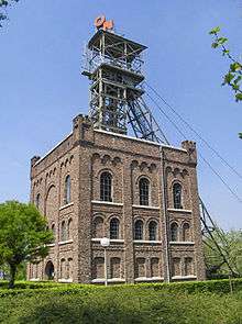
In the 19th century, Heerlen, like most of Limburg municipalities (Maastricht was an exception), did not partake in the Industrial Revolution and it remained largely agrarian until coalmining began in the late 19th/early 20th century. In March 1874, coal had been found at the Valkenburgerweg. However, setting up a mine is a risky long-term investment and only very few private enterprises took up the challenge and bought a concession. In 1896 Heerlen got its first railway connection to allow the transportation of coal from these first coal mines. Development was still rather slow: In 1812 Heerlen had a population of 3497, in 1900 this was still only 6646. In 1901, the national government stepped in and bought all remaining unsold concessions and set up the State Mines. In a short period of time several large state-operated coalmines began production. The population rose sharply from 6646 in 1900 to 12,098 in 1910 to 32,263 in 1930.[7] During these early expansion years many old buildings in the centre of Heerlen were demolished. The coalmines remained central to the development of Heerlen into a modern city until the early 1960s, the period during which mayor Van Grunsven was mayor of Heerlen. The golden years of coalmining ended in the late 1950s, after which production gradually diminished due to competition from cheaper Polish and American coal and the discovery of natural gas in the province of Groningen. In the period 1965–1975 the coalmines were closed altogether. In the area around Heerlen-Kerkrade-Brunssum and Sittard-Geleen 60,000 people lost their jobs. A difficult period of economic re-adjustment started. The Dutch government tried to ease the pain by moving several governmental offices (ABP, CBS) to Heerlen but even today the city has not fully recovered from the loss of tens of thousands of jobs. In the cityshape of modern-day Heerlen very little reminds us of the once omni-present mining industry. Most of the typical mounts of mining debris that surrounded the coal mines, have been removed or transformed into green hills during an operation called van zwart naar groen (from black to green). Even the tallest mine chimney of Europe, 'Lange Lies' (tall Liz) and her older brother 'Lange Jan' (tall John), once major landmarks, were demolished. One of the few remaining mining buildings (shaft 2 of the Oranje Nassau I) now houses the Dutch Mine Museum.
Geography


Heerlen is located at 50°53′N 5°59′E / 50.883°N 5.983°E in the province of Limburg in the southeast of the Netherlands on the border with Germany. It is situated in the COROP region of South Limburg and is part of the agglomeration Parkstad Limburg, formerly known as Oostelijke Mijnstreek.
Heerlen is bordered by the Dutch municipalities of Simpelveld (in the south), Voerendaal and Nuth (west), Schinnen (northwest), Brunssum (north), Landgraaf and Kerkrade (east), and the German municipality of Aachen (southeast).
Education
Among the educational institutes in Heerlen is Hogeschool Zuyd, which is a University of Applied Sciences with branches in Heerlen, Sittard and Maastricht. Also based in Heerlen is the administrative office of the Open University of the Netherlands (Open Universiteit or OU in Dutch), which is a university for distance learning with tens of thousands of students throughout the Netherlands. Heerlen was also the location of the now defunct University of Theology and Pastorate (Universiteit van Theologie en Pastoraat or UTP in Dutch), which had to close down due to lack of students. Jokingly it was said that Heerlen was the location of the biggest (OU) and the smallest (UTP) university of the Netherlands.
Health care
Health care in Heerlen (and the rest of the Parkstad Limburg) is provided by Stichting Gezondheidszorg Oostelijk Zuid-Limburg (G.O.Z.L.). Atrium Medisch Centrum Parkstad (Atrium Medical Center Parkstad), is the name of the different hospitals in the Parkstad, and is part of G.O.Z.L. Atrium Medisch Centrum Parkstad location Heerlen was previously known as De Wever ziekenhuis named after Frans de Wever, who in 1904, together with mgr. Joseph Savelberg, founded the first hospital in Heerlen.
Architecture
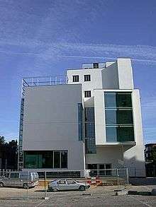

The city's best known architect is without doubt Frits Peutz. His legacy consist of at least 10 landmark buildings in Heerlen. In 1935 Heerlen's most famous landmark building, the Glaspaleis, was built next to the medieval church in the centre of the then modest town. It was commissioned by the merchant Peter Schunck and it was quite an extraordinary step for this conservative businessman to ask the young Heerlen-based architect Peutz to design the new Schunck department store. It is one of the most outstanding examples of early Modernism in The Netherlands but it was only recognized as such at a fairly late stage (after it had been badly maimed). In the 1990s it was added to a prestigious list of the world's 1000 most important buildings of the 20th century created by the International Union of Architects (only 13 buildings in the Netherlands are on that list). It encouraged the city administrators to buy the dilapidated building and make plans for its renovation. The renovation has now been completed and it now houses several of the city's cultural institutions, including a museum of modern art. The renovated Glaspaleis has become a symbol of the revived Heerlen after the closing of the coalmines.
Although many interesting buildings were demolished around 1900, some older buildings still exist in the centre of Heerlen, for instance a Romanesque style 12th-century church (Pancratiuskerk), and a former prison tower from around the same period (Schelmentoren).
Other buildings worth mentioning are a Neoclassical chapel (Grafkapel de Loë built in 1848, the only remaining Neoclassical building in Heerlen), and a former mansion annex pharmacy, left in almost the same state as after its 1801–1828 expansion (Huis de Luijff).
In other parts of Heerlen, especially near the numerous small rivers around Heerlen, many more older buildings can be found, noticeably a couple of watermills (like the Weltermolen (14th century), Eikendermolen (15th century), Oliemolen (16th century), and Schandelermolen (17th century)), some castles (for instance Hoensbroek Castle oldest part 1380, Kasteel Terworm 15th century) and old farms (Geleenhof (dating back to Roman days), Benzeraderhof (13th century, Hoeve Den Driesch (14th century), Overste Douvenrade (largely destroyed and rebuilt in 1779) and Hoeve de Bek (1796)).
Architects with significant work
Here follows a list of architects who have built important landmarks in Heerlen, and those landmarks.
- A van Beers: Huize Op de Berg (1897)
- Johan Kayser, (1842, Harlingen – 1917): Chapel Savelberg Convent (1878–1879, style: Neo-Gothic)
- Jan Stuyt (1868–1934)): Ambachtsschool (1913, style: Hollands Classicisme[8])
- J. Pauw: Former library (1917, style: Amsterdam School)[8]
- Dirk Roosenburg (1887–1962): Former office Oranje Nassau mine (1928, style: International style)
- Dirk Brouwer (November 3, 1899 – 1941): Former HEMA building (1939, style: International style)
- Frits Peutz (April 7, 1896 - October 24, 1974): Glaspaleis (1933, style: International style), Monseigneur Schrijnen Retreat House (1932), townhall (1940), municipal theatre
- Gerrit Rietveld, (Utrecht June 24, 1888- Utrecht June 26, 1964): house on Zandweg (1961–1964)
- Jo Coenen (born 1949 in Heerlen-Hoensbroek): Library and entrance Stadsgalerij (1983, 1989)
People from Heerlen
A chronological list of notable Heerlenaren (inhabitants of Heerlen):[9]
- M. Sattonius Iucundus (third century), Roman politician
- Theoderich van Are (1087–1126), count[10]
- Anna Sophia van Schönborn (1696–1760), countess
- Jacob Derk Carel van Heeckeren (1730–1795), politician
- Jan Gerard Kemmerling (1776–1818), mayor of Heerlen
- Jan Michiel Dautzenberg (1808–1869), Belgian writer
- Egidius Slanghen (1820–1882), politician
- Joseph Savelberg (1827–1907), Roman Catholic priest
- Henri Sarolea (1844–1900), entrepreneur
- Frans de Wever (1869–1940), general practitioner
- Marcel van Grunsven (1896–1969), mayor of Heerlen
- Agnes Giebel (born 1921), soprano
- Thomas Bernhard (1931–1989), Austrian playwright and novelist
- Theo Bemelmans (born 1943), computer scientist
- Klaas de Vries (born 1943), politician
- Margriet Ehlen (born 1943), composer and poet
- Jo Ritzen (born 1945), politician
- Loek Hermans (born 1951), politician[11]
- Wiel Arets (born 1955), architect
- Fernando Ricksen (born 1976), footballer
- Suzan Erens (born 1976), concert singer
- Simone Simons (born 1985), singer of Epica
- Ian Brown (born 1986), English musician
- Shirley Kocaçınar (born 1986), footballer
- Danny Hoesen (born 1991), footballer
Mines
List of mines which were located in what is now Heerlen
- Oranje Nassau I, 1899–1974, now used in the Minewater Project
- Oranje Nassau III, 1917–1973, now used in the Minewater Project
- Oranje Nassau IV, 1927–1966
- Staatsmijn Emma, 1911–1973
Transport
Heerlen has three railway stations:
From Heerlen you can travel to Eindhoven, Utrecht, Amsterdam, Maastricht, Kerkrade and into Germany.
Economy
Heerlen houses the biggest Furniture strip of Europe, with 120,000 m² floorspace after the opening of the biggest (35,000 m²) Ikea of the Benelux on the 27th of August 2008.
On October 1, 2008, the World’s first minewater power station was opened in Heerlen. It will be used to heat and cool 200 homes, along with shops, a supermarket, a library and large office buildings
Sports
The GP Heerlen is a February cyclo-cross race held in Heerlen.
References
- ↑ "Burgemeester Paul Depla" [Mayor Paul Depla] (in Dutch). Gemeente Heerlen. Retrieved 12 October 2013.
- ↑ "Kerncijfers wijken en buurten" [Key figures for neighbourhoods]. CBS Statline (in Dutch). CBS. 2 July 2013. Retrieved 12 March 2014.
- ↑ "Postcodetool for 6411HP". Actueel Hoogtebestand Nederland (in Dutch). Het Waterschapshuis. Retrieved 12 October 2013.
- ↑ "Bevolkingsontwikkeling; regio per maand" [Population growth; regions per month]. CBS Statline (in Dutch). CBS. 26 June 2014. Retrieved 24 July 2014.
- ↑ "Bevolkingsontwikkeling; regio per maand" [Population growth; regions per month]. CBS Statline (in Dutch). CBS. 26 June 2014. Retrieved 24 July 2014.
- ↑ Heerlen
- ↑ Groei van dorp naar stad
- 1 2 Beschrijving route
- ↑ Dorpsfiguren en notabelen
- ↑ http://www.eventjesuit.nl/smartsite.dws?id=3219
- ↑ L1 - nieuws en sport uit Limburg
External links
| Wikimedia Commons has media related to: |
-
 Heerlen travel guide from Wikivoyage
 - Official website
- Thermae Museum
- Coriovallum
 |
Schinnen | Brunssum | | |
| Nuth Voerendaal |
|
Landgraaf Kerkrade | ||
| ||||
| | ||||
| Simpelveld | Aachen (DE-NW) |