Harrisville, Michigan
| Harrisville | |
|---|---|
| City | |
|
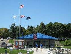
Harrisville Harbor, Labor Day Weekend 2007 | |
 Location of Harrisville, Michigan | |
| Coordinates: 44°39′28″N 83°17′41″W / 44.65778°N 83.29472°W | |
| Country | United States |
| State | Michigan |
| County | Alcona |
| Area[1] | |
| • Total | 0.61 sq mi (1.58 km2) |
| • Land | 0.61 sq mi (1.58 km2) |
| • Water | 0 sq mi (0 km2) |
| Elevation | 623 ft (190 m) |
| Population (2010)[2] | |
| • Total | 493 |
| • Estimate (2012[3]) | 481 |
| • Density | 808.2/sq mi (312.0/km2) |
| Time zone | EST (UTC-5) |
| • Summer (DST) | EDT (UTC-4) |
| ZIP code | 48740 |
| Area code(s) | 989 |
| FIPS code | 26-36860[4] |
| GNIS feature ID | 0627866[5] |
Harrisville is a city in the U.S. state of Michigan and the county seat of Alcona County.[6] The population was 493 at the 2010 census. The city is surrounded by Harrisville Township, but is administratively autonomous. Located on Lake Huron, it is an official Michigan Department of Natural Resources Harbor of Refuge.[7]
The place was first known as "Davison's Mill" after Crosier Davison, who in partnership with Simeon Holden, had purchased land and water power rights here in 1854. Benjamin Harris and his sons, Levi and Henry, of West Bloomfield, New York. A post office established in 1857 was named Harrisville, after the family operations. It was platted in 1870, incorporated as a village in 1887, and as a city in 1905.[8]
Harrisville is on the edge of Huron National Forest, which offers outdoor recreational opportunities such as hunting, swimming, cross-country skiing and trout fishing. The forest contains 330 miles (530 km) of hiking trails. The Huron and Manistee National Forests were separately designated, but were combined in 1945 for administrative purposes.
The Lake Huron beaches in and around Harrisville (including two state parks) have been recognized as being among the "top ten in Michigan." "Old-fashioned lake vacations abound on this pretty stretch of Lake Huron."[9]
Harrisville is situated along the Lake State Railway, formerly the Detroit and Mackinac Railway (D&M). The D&M passenger depot is made of stone, which makes it one of two along the railway (the other being in Standish).[10] It is privately maintained by local citizens as part of the municipality's historical legacy.[11]
Geography
According to the United States Census Bureau, the city has a total area of 0.61 square miles (1.58 km2), all land.[1] It is considered to be part of Northern Michigan.
The city is on the western shore of Lake Huron and has a harbor for recreational boaters. The harbor is a center for salmon and trout fishing.[12] It is also a designated "Harbor of Refuge" on Lake Huron by the US Coast Guard.
The town also boasts Harrisville State Park, which includes a wooded campground along the beach.
Sturgeon Point Light Station, a lighthouse and museum, is a few miles to the north, and is open to the public.[13]
Demographics
| Historical population | |||
|---|---|---|---|
| Census | Pop. | %± | |
| 1880 | 549 | — | |
| 1890 | 987 | 79.8% | |
| 1900 | 403 | −59.2% | |
| 1910 | 444 | 10.2% | |
| 1920 | 460 | 3.6% | |
| 1930 | 438 | −4.8% | |
| 1940 | 437 | −0.2% | |
| 1950 | 485 | 11.0% | |
| 1960 | 487 | 0.4% | |
| 1970 | 541 | 11.1% | |
| 1980 | 559 | 3.3% | |
| 1990 | 470 | −15.9% | |
| 2000 | 514 | 9.4% | |
| 2010 | 493 | −4.1% | |
| Est. 2015 | 470 | [14] | −4.7% |
| Source: Census Bureau. Census 1960- 2000, 2010. | |||
2010 census
As of the census[2] of 2010, there were 493 people, 231 households, and 130 families residing in the city. The population density was 808.2 inhabitants per square mile (312.0/km2). There were 329 housing units at an average density of 539.3 per square mile (208.2/km2). The racial makeup of the city was 96.6% White, 0.6% African American, 1.0% Native American, 0.2% Asian, 0.6% from other races, and 1.0% from two or more races. Hispanic or Latino of any race were 2.4% of the population.
There were 231 households of which 18.2% had children under the age of 18 living with them, 42.4% were married couples living together, 11.7% had a female householder with no husband present, 2.2% had a male householder with no wife present, and 43.7% were non-families. 38.5% of all households were made up of individuals and 20.3% had someone living alone who was 65 years of age or older. The average household size was 1.96 and the average family size was 2.55.
The median age in the city was 51.6 years. 16.4% of residents were under the age of 18; 5% were between the ages of 18 and 24; 20.2% were from 25 to 44; 29% were from 45 to 64; and 29.6% were 65 years of age or older. The gender makeup of the city was 45.0% male and 55.0% female.
2000 census
As of the census[4] of 2000, there were 514 people, 239 households, and 131 families residing in the city. The population density was 831.2 per square mile (320.1/km²). There were 327 housing units at an average density of 528.8 per square mile (203.6/km²). The racial makeup of the city was 94.94% White, 2.14% African American, 0.39% Native American, 0.97% Asian, and 1.56% from two or more races. Hispanic or Latino of any race were 0.97% of the population.
There were 239 households out of which 18.4% had children under the age of 18 living with them, 44.4% were married couples living together, 8.4% had a female householder with no husband present, and 44.8% were non-families. 41.4% of all households were made up of individuals and 22.6% had someone living alone who was 65 years of age or older. The average household size was 1.92 and the average family size was 2.57.
In the city the population was spread out with 16.0% under the age of 18, 7.4% from 18 to 24, 21.6% from 25 to 44, 25.9% from 45 to 64, and 29.2% who were 65 years of age or older. The median age was 48 years. For every 100 females there were 96.2 males. For every 100 females age 18 and over, there were 93.7 males.
The median income for a household in the city was $27,500, and the median income for a family was $34,286. Males had a median income of $23,625 versus $21,875 for females. The per capita income for the city was $16,983. About 9.3% of families and 13.6% of the population were below the poverty line, including 20.8% of those under age 18 and 6.5% of those age 65 or over.
Transportation
Major highways
 US 23, north of Standish, it has been designated the Sunrise Side Coastal Highway, and runs along the Lake Huron shoreline. US 23 is the most proximate connector to I-75, to which it connects in Standish, about 75 miles (121 km) to the south. About 135 miles (217 km) to the north is Mackinaw City and the Mackinac Bridge and the north end of the lower peninsula's I-75.
 M-72 In 1936, downtown Harrisville became the eastern terminus[15] of the 133-mile (214 km) M-72, which runs across the lower peninsula from Empire. It is one of three true cross-peninsular highways.[16]
Bus
- Indian Trails provides daily intercity bus service between St. Ignace and Bay City, Michigan.[17]
Airport
Harrisville City Airport is 2200 feet (671 m) in length; it is located on Walker Road.[18] A larger public airport that serves the area and has nearly all weather capability is Oscoda-Wurtsmith Airport.
Local events

Harrisville and environs have many recurrent annual events.[19]
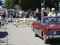
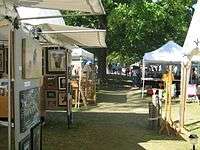
- Harrisville Arts & Crafts Show - Each Labor Day weekend there is a regional craft show, parade, and national jamboree often referred to as Harmony Weekend.[20] Hundreds of exhibitors display their product to over one hundred thousand visitors. The event is sponsored by the Harrisville Arts Council and the Society for the Preservation and Encouragement of Barber Shop Quartet Singing in America.
- Sunrise Side Wine and Food Festival, a Michigan tradition featuring award-winning Michigan wines, delectable local foods and artisan breads, original art show, live jazz performances and a scenic view of Lake Huron under the big Festival Tent at Harrisville Harbor, the third Saturday in July.[21]
- Contemporaneous with the Arts and Crafts Show weekend, The Barbershop Harmony Society, legally and historically named the Society for the Preservation and Encouragement of Barber Shop Quartet Singing in America, Inc. (SPEBSQSA), has a large regional contest and meeting.
- Dragon Days (including a chili cook-off) at the Harrisville depot.[22]
- Independence Day Parade and Fireworks – Free concerts, a parade through downtown and a spectacular fireworks display.
- Craftmaker's Cabin Arts and Crafts Show, July 5 and 6 (at the cabin, intersection of Main Street (M-72) and US-23).[19]
- Antique Show at the Harrisville Harbor.
- Strawberry social at the Old Bailey School - Held on the last Sunday of June. The Old Bailey School is a 1907 one room school adjacent to the Sturgeon Point Light Station.[23]
- Sturgeon Point Light Station Sanctuary Bay Sailboat Race - A fundraiser for the Alcona County Historical Society, including a community event on the beach, is held the first Saturday in August.
- Concert in the Park, Wednesday evenings during the summer at the Harbor.[24]
City of Harrisville elected officials
- Mayor John Dobis (R)(989) 724-9340[25]
- Clerk Barbara Pierce (R)(989) 724-6666[25]
- Treasurer Thomas Keerl (R) (989) 724-6804[25]
- Alderman Ward I Paul T. Dwyer, (R) (989) 724-6444[25]
- Alderman Ward II Joan Crick (D) (989) 724-6546[25]
- Alderman Ward II James Kaiser (D) (989) 724-5136[25]
- Alderman Ward III Noel Lemere (D) (989) 724-5370[25]
- Alderman Ward III Barbara Pierce (D) (989) 724-7501[25]
- Assessor Randy Thompson (989) 724-5603[25]
- Zoning Administrator Bruce Dunn (989) 724-6666[25]
- Harrisville Fire Department Non-emergency (989) 724-6271[25]
Meetings - Second Monday Harrisville City Hall (Fire Station next to County Bldg.)[25]
(information as of May 2012)
Notable residents
- Harrisville is home to the legal offices of Pamela Burt, an attorney who in 2005 succeeded in getting the Michigan Supreme Court to throw out an appellate court's decision that had equated wayward beach walking to trespassing, while leaving intact the principle that owners of property abutting the Great Lakes own to the current water edge.[26]
- Harrisville is the summer home of author and screenwriter Judith Guest.[27]
- Casey Makela, the author of bestselling books on soap making,[28] and owner of the Killmaster Soap & Woolen Works,[29] lives in Harrisville.
- Harrisville was the birthplace, home town and burial place of Baseball Hall of Famer Hazen Shirley "Kiki" Cuyler, and he is memorialized on a section of M-72 and in a local baseball field. A local bar that he owned still bears his name.[30]
Media
- The Alcona County Review, located in Harrisville, is the newspaper of record, and has served the community since 1877.[31]
- The Alpena News[32] is the daily newspaper of record for much of northeastern lower peninsula of Michigan.[33]
- Daily editions of the Detroit Free Press and The Detroit News are also available throughout the area.
Further reading
- "Bibliography on Alcona County". Clarke Historical Library, Central Michigan University. Retrieved January 17, 2013. (including Harrisville)]
- "History of Alcona County". History of the Lake Huron shore. With illustrations and biographical sketches of some of its prominent men and pioneers. Ann Arbor, Mich.: University of Michigan Library. 2005 [1883]. pp. 255–274. Retrieved 2007-04-11.
- Powers, Perry Francis (2005) [1912]. "Alcona County". A history of northern Michigan and its people. Ann Arbor, Mich.: University of Michigan Library. pp. 498–505. Retrieved 2007-04-11.
Other affiliations
Harrisville is part of the Roman Catholic Diocese of Gaylord.[34]
Notes
- 1 2 "US Gazetteer files 2010". United States Census Bureau. Retrieved 2012-11-25.
- 1 2 "American FactFinder". United States Census Bureau. Retrieved 2012-11-25.
- ↑ "Population Estimates". United States Census Bureau. Retrieved 2013-06-03.
- 1 2 "American FactFinder". United States Census Bureau. Retrieved 2008-01-31.
- ↑ "US Board on Geographic Names". United States Geological Survey. 2007-10-25. Retrieved 2008-01-31.
- ↑ "Find a County". National Association of Counties. Retrieved 2011-06-07.
- ↑ "DNR - Harbors". michigan.gov.
- ↑ Romig, Walter (1986) [1973]. Michigan Place Names. Detroit, Michigan: Wayne State University Press. ISBN 0-8143-1838-X.
- ↑ Detroit Free Press, May 26, 2007
- ↑ "How Harrisville got a Stone Depot". michiganrailroads.com.
- ↑ Detroit and Mackinac Railway Harrisville station.
- ↑ "Facts To Consider Before You Sell Gold". hvharbor.com.
- ↑ Sturgeon Point lighthouse and museum
- ↑ "Annual Estimates of the Resident Population for Incorporated Places: April 1, 2010 to July 1, 2015". Retrieved July 2, 2016.
- ↑ "Photos of ends of M-72.". state-ends.com.
- ↑ History of Michigan highways.
- ↑ "BAY CITY-ALPENA-CHEBOYGAN-ST. IGNACE" (PDF). Indian Trails. March 19, 2013. Retrieved 2013-04-03.
- ↑ Harrisville City Airport map
- 1 2 "US 23 Coastal Highway". US 23 Coastal Highway.
- ↑ "Harmony Weekend," Harrisville Arts Council, Accessed December 9, 2007.
- ↑ "Sturgeon Point Lighthouse - Search Results - Michigan in Pictures". wordpress.com.
- ↑ "visitalconacounty.com". visitalconacounty.com.
- ↑ "Huronshorescc.com". huronshoreschamber.com.
- ↑ "Wildernet.com - Harrisville State Park, Michigan State Parks and Forests". wildernet.com. line feed character in
|title=at position 14 (help) - 1 2 3 4 5 6 7 8 9 10 11 12 "list of elected officials". Alcona County Review. Retrieved May 1, 2012.
- ↑ "Text of Opinion: Glass v. Goeckel" (PDF). Lansing, Michigan: Michigan Supreme Court. July 2005. Retrieved August 28, 2013.
- ↑ "Judith Guest". Judith Guest.
- ↑ "2002 Shows," Michigan Magazine, Accessed December 9, 2007.
- ↑ Killmaster (named for lumberman John Killmaster, its founder who is buried in Harrisville) is a ghost town in Alcona County. See Gustin Township, Michigan.
- ↑ "Kiki Cuyler". Baseball reference.com. Retrieved May 7, 2012.
- ↑ "Alcona County Review - The Weekly Newspaper of Record For Alcona County Michigan". alconareview.com.
- ↑ The Alpena News
- ↑ Alpena News
- ↑ "The Diocese of Gaylord, Michigan : A Diocese of the Roman Catholic Church - Diocese of Gaylord". dioceseofgaylord.org.
External links
| Wikimedia Commons has media related to Harrisville, Michigan. |
- Alcona County Review
- Alcona County Historical Society
- Alpena News (serving northeastern lower pensinula of Michigan)
- Enchanted forest, Northern Michigan source for information, calendars, etc.
- Harrisville City Airport information and map
- Great Lakes Coast Watch
- How Harrisville got a Stone Depot
- Huron Shores Chamber of Commerce, with links to local concerns, events, links, merchants, etc.
- Information and links about Harrisville
Municipalities and communities of Alcona County, Michigan, United States | ||
|---|---|---|
| City | 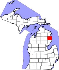 | |
| Village | ||
| Townships | ||
| Unincorporated communities | ||
Coordinates: 44°39′23″N 83°17′41″W / 44.65639°N 83.29472°W