Hempstead Historic District
|
Hempstead Historic District | |
 | |
  | |
| Location | Roughly bounded by Franklin Street, Jay Street and Mountain Avenue, New London, Connecticut |
|---|---|
| Coordinates | 41°21′13″N 72°6′13″W / 41.35361°N 72.10361°WCoordinates: 41°21′13″N 72°6′13″W / 41.35361°N 72.10361°W |
| Area | 29 acres (12 ha) |
| Architect | Bishop,David; Et al. |
| Architectural style | Greek Revival, Italianate, Gothic Revival;Queen Anne |
| NRHP Reference # | 86002112[1] |
| Added to NRHP | July 31, 1986 |
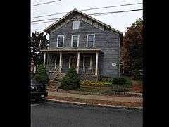
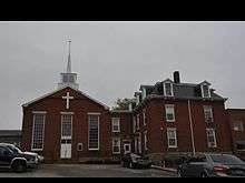
The Hempstead Historic District of New London, Connecticut encompasses a residential area north of the city's harbor and central business district, extending mainly along three roughly parallel streets: Franklin and Hempstead Streets, and Mountain Avenue. The area was first settled in the 17th century (the Joshua Hempsted House at 11 Hempstead Street dates to 1678), but significant development did not begin until the 1840s, and took place roughly over the next century. The district has 142 houses, most of which were built within that time period, and have retained their historical integrity. Notable non-residential structures include the 1845 Greek Revival New London County Jail (now the Shiloh Baptist Church), and the Renaissance Revival Saltonstall School, built in 1903.[2]
The district was listed on the National Register of Historic Places on July 31, 1986.[1]
See also
References
- 1 2 National Park Service (2009-03-13). "National Register Information System". National Register of Historic Places. National Park Service.
- ↑ "NRHP nomination for Hempstead Historic District" (PDF). National Park Service. Retrieved 2015-01-26.
| Topics | |
|---|---|
| Lists by states |
|
| Lists by insular areas | |
| Lists by associated states | |
| Other areas | |
| |