Herat Province
| Herat هرات | |
|---|---|
| Province | |
|
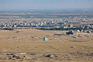
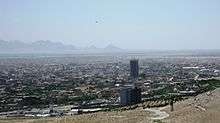
Scenery around the city of Herat | |
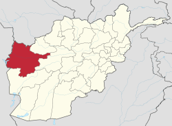 Map of Afghanistan with Herat highlighted | |
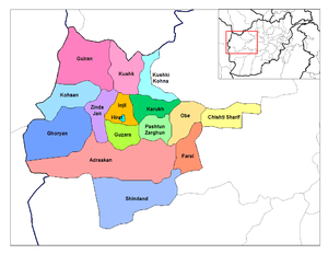
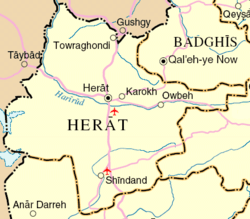 Detail map of Herat province | |
| Coordinates (Capital): 34°00′N 62°00′E / 34.0°N 62.0°ECoordinates: 34°00′N 62°00′E / 34.0°N 62.0°E | |
| Country |
|
| Capital | Herat |
| Government | |
| • Governor | Mohammad Asif Rahimi |
| Area | |
| • Total | 54,778.0 km2 (21,149.9 sq mi) |
| Population (2015)[1] | |
| • Total | 1,890,202 |
| • Density | 35/km2 (89/sq mi) |
| Time zone | UTC+4:30 |
| ISO 3166 code | AF-HER |
| Main languages |
Dari (Afghan Persian) Pashto |
Herat (Pashto/Dari: هرات) is one of the thirty-four provinces of Afghanistan, located in the western part of the country. Together with Badghis, Farah, and Ghor provinces, it makes up the south-western region of Afghanistan. Its primary city and administrative capital is Herat City. The province of Herat is divided into about 17 districts and contains over 1,000 villages. It has a population of about 1,780,000, making it the second most populated province in Afghanistan behind Kabul Province.[2] The population is multi-ethnic but largely Persian-speaking.
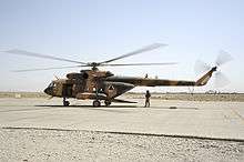
Herat province shares border with Iran in the west and Turkmenistan in the north, making it an important trading province. The Trans-Afghanistan Pipeline (TAPI) is expected to pass through Herat from Turkmenistan to Pakistan and India in the south. The province has two airports, one is the Herat International Airport in the capital of Herat and the other is at the Shindand Air Base, which is one of the largest military bases in Afghanistan. The Salma Dam which is fed by the Hari River is also located in this province.
History
The region of Herat was historically part of Greater Khorasan, which was successively controlled by the Tahirids followed by the Saffarids, Samanids, Ghaznavids, Ghurids, Ilkhanates, Timurids, Safavids, Hotakis, Durranis until it became part of the modern state of Afghanistan.
During the 19th century, the British arrived from southern Afghanistan as part of its imperialistic policies and backed up the Afghans during one Dari siege and one capture of the city, the former in 1838, and the latter in 1856 in order to prevent Dari or Russian influence reaching deeper in South Asia, and also, more importantly, Britain's colony India as part of the Great Game. In the process, parts of the city of Herat were destroyed. The province remained peaceful until the 1979 Soviet invasion.
The province saw a number of battles during the 1980s Soviet war, and remained an active area of guerrilla warfare throughout, with local mujahideen commander Ismail Khan leading resistance against the Soviet-backed Afghan government. This continued until the Soviet Union withdrew all its forces in 1989.
When the Soviets withdrew from Afghanistan, Ismail Khan became the governor of the province, a position he retained until the Taliban forces from the south took control of the province in 1995. Following the ousting of the Taliban and establishment of the Karzai administration, led by Hamid Karzai, Ismail Khan once again became governor of Herat.
Ismail Khan become a figure of controversy when the media began reporting that he was attempting to restrict freedom of the people, and that he was becoming more of an independent ruler as a warlord. He lost a son Mirwais Sadiq in 2004 during a fight with forces of other warlords. In response to this, the central government began expanding into the provide with the newly trained Afghan National Security Forces (ANFS). Ismail Khan was ordered to leave his post to become a minister and live in Kabul.
After 2005, the International Security Assistance Force (ISAF) established presence in the area to help assist the Afghan government. It is led by Italy. A multi-national Provincial Reconstruction Team (PRT) was also established to help the local population of the province. The United States established a consulate in Herat, trained Afghan security forces, built schools, and clinics.
Herat was one of the first seven areas that transitioned security responsibility from NATO to Afghanistan. On July 21, 2011, Afghan security forces assumed lead security responsibility from NATO. On the occasion, Minister of Defense Wardak told the audience, "this is our national responsibility to take over our security and defend our country."
Politics and governance
The current governor of the province is Mohammad Asif Rahimi, and before him was Fazlullah Wahidi who had succeeded Daud Shah Saba in 2013.
The provincial Police Chief, who leads the regular Afghan National Police (ANP) and the Afghan Border Police (ABP), is responsible for all law enforcement activities. The Police Chief represents the Ministry of the Interior in Kabull.
Economy
The province is home to 90% of Afghanistan's Saffron production (a $12 million industry in 2014).[3] In 2015 the World Bank noted that saffron cultivation had provided Herat Province's farmers a steady source of income, jobs for both men and women, and a decreased dependency on poppy cultivation.[3]
With international borders to Iran and Turkmenistan and an international airport trade could potentially play an important part in the economy of Herat Province.[4] Due to the lack of urbanization in Herat Province, around 75% of the population lives in rural areas and economic activity is correspondingly heavily reliant on agriculture and horticulture production (saffron, rugs, cumin, marble, animal skins and wool[4]) with around 82% of economic activity coming from these fields in 2011.[5] Marble manufacturing and light industry comprised the remaining areas of economic activity.[5]
Healthcare
The percentage of households with clean drinking water fell from 31% in 2005 to 28% in 2011.[6] The percentage of births attended to by a skilled birth attendant increased from 24% in 2005 to 25% in 2011.[6]
Education
The overall literacy rate (6+ years of age) fell from 36% in 2005 to 25% in 2011.[6] The overall net enrolment rate (6–13 years of age) fell from 55% in 2005 to 52% in 2011.[6] Herat University is Afghanistan's second largest university with over 10,000 students, 14 faculties and 45 departments in 2014.
Demographics
The total population of the province is about 1,780,000, the majority of which live in rural parts.[2] Persian-speaking Tajiks form the majority.[7] According to Afghanistan's Ministry of Rural Rehabilitation and Development:
"Around three quarters (77%) of the population of Hirat lives in rural districts while just under a quarter (23%) lives in urban areas. Around 50% of the population is male and 50% is female. Dari and Pashtu are spoken by 98% of the population and 97.7% of the villages. Languages spoken by the remaining population are Turkmeni and Uzbeki.[8]
Hirat province also has a population of Kuchis or nomads whose numbers vary in different seasons. In winter 98,506 individuals, or 4.1% of the overall Kuchi population, stay in Hirat living in 166 communities. Around Three quarters (75%) of these are short-range partially migratory, 12% are long-range partially migratory and 13% are settled. Half of migratory communities of both categories migrate within the winter area, as well as in the summer area. The most important summer areas for the short range migratory Kuchi are Kushki Sangi, Farsi, Adreskan, Kushk Kohna, Kushk Robad, Pashtun Zarghun, Shindand, Guzara, Chisht Sharif, Obeh, Kohistan and Karukh districts of Herat province (in decreasing order of importance). The long-range migratory Kuchi are predominantly fully migratory. Their summer areas are in Ghor province. The Kuchi population in the summer is 112311 individuals."[8]
Population by districts
The province is divided into about 17 districts and contains over 1,000 villages.
| District | Capital | Population[2] | Area | Number of villages and ethnic groups |
|---|---|---|---|---|
| Adraskan | 52,200 | 10,070 km2 | 270 villages. 95% Pashtun and 5% Tajik.[9] | |
| Chishti Sharif | 23,100 | |||
| Farsi | 29,800 | |||
| Ghoryan | 85,900 | 7,385 km2 | 311 villages.[10] | |
| Gulran | 91,500 | |||
| Guzara | 142,700 | |||
| Herat | Herat | 436,300 | Tajik, Pashtun, Hazara, Uzbek, Turkmen and others.[11] | |
| Injil/Enjil | 237,800 | |||
| Karukh | 62,000 | |||
| Kohsan | 52,900 | |||
| Kushk | 121,000 | 2,909 km2 | 158 villages. 40% Tajik, 58% Pashtun, and 2% Arab and Baloch.[12] | |
| Kushki Kuhna | 44,400 | 1,671 km2 | 142 villages. Tajik and Pashtun.[13] | |
| Obe | 73,600 | 2,634 km2 | 145 villages.[14] | |
| Pashtun Zarghun | 97,500 | 172 villages. Pashtun, Tajik, Agha, Mughul, Zori, Arab, Ghurya, Timani, Timori, Qabchaq, Khaja, Jamshidi, Baluch, Hazara and Jushan.[15] | ||
| Shindand | Shindand | 173,800 | ||
| Zinda Jan | 55,500 |
Sport
Football (soccer) is the popular sport in Herat Province, and in recent years cricket is also growing in popularity. The Province is represented in domestic competitions by the Herat Province cricket team. Afghanistan's national sport Buzkashi and a number of other sports are also played in the region.
Famous People from Herat
- Sultan Husayn Mirza Bayqara - Ruler of Herat of Timurid dynasty
Future
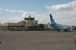
In December 2012, Afghanistan and Italy signed a "long term agreement" including a Euro 150 million soft loan facility for infrastructure projects in Herat Province. In 2014 the agreement for a first soft loan worth about US$32 million was agreed for the upgrade of the Herat airport. In 2016 a second soft loan agreement worth about US$100 million was signed between Afghanistan a and Italy for the construction a 155 km road between Herat and Chist-e Sharif. Italy also agreed to assess the possibility of a third soft loan worth about US$70 million for completing the railroad connection between Herat and Mashad in Iran. The Asian Development Bank is also implementing a feasibility study for the construction of a railway connection between Herat and Turkmenistan.
See also
- Provinces of Afghanistan
- Train Advise Assist Command - West
- Provincial Reconstruction Team (PRT)
- Azizabad airstrike
References
- ↑ Afghanistan at GeoHive
- 1 2 3 "Settled Population of Herat province by Civil Division, Urban, Rural and Sex-2012-13" (PDF). Islamic Republic of Afghanistan, Central Statistics Organization. Retrieved 2012-10-22.
- 1 2 The World Bank, Saffron: A Major Source of Income and an Alternative to Poppy, 19 January 2015, http://www.worldbank.org/en/news/feature/2015/01/20/saffron-major-source-income-alternative-poppy
- 1 2 Asia Times, Herat trade on the up and up, By Mohammad Ali Jawed and Harun Hakimi, 13 April 2012, http://www.atimes.com/atimes/South_Asia/ND13Df02.html
- 1 2 Summer 2012, Herat Economic Corridor Could Catalyze Growth in Western Afghanistan, By David Fischer, http://dai-global-developments.com/articles/herat-economic-corridor-could-catalyze-growth-in-western-afghanistan/
- 1 2 3 4 Archive, Civil Military Fusion Centre, https://www.cimicweb.org/AfghanistanProvincialMap/Pages/Herat.aspx
- ↑ https://books.google.com/books?id=BIyVMkjat2MC&pg=PA73&dq=herat+majority+fars&ei=kGqCSqn1HouskASkw-CVBA#v=onepage&q=&f=false
- 1 2 "B. Demography and Population" (PDF). United Nations Assistance Mission in Afghanistan and Afghanistan Statistical Yearbook 2006, Central Statistics Office. Afghanistan's Ministry of Rural Rehabilitation and Development. Retrieved 2011-01-12.
- ↑ Adraskan District
- ↑ Ghoryan District
- ↑ "2003 National Geographic Population Map" (PDF). Thomas Gouttierre, Center For Afghanistan Studies, University of Nebraska at Omaha; Matthew S. Baker, Stratfor. National Geographic Society. 2003. Retrieved 2011-04-11.
- ↑ Kushk Robat Sangi District
- ↑ Kusk-e-Kohna District
- ↑ Obeh District
- ↑ Pashtun Zarghun District
 |
Mary Province, |
Badghis Province | | |
| Razavi Khorasan Province, |
|
Ghor Province | ||
| ||||
| | ||||
| South Khorasan Province, |
Farah Province |
| Capital | | |
|---|---|---|
| Districts | ||
| Cities | ||
| Landmarks |
| |