Interstate 66
| |||||||
|---|---|---|---|---|---|---|---|
| Custis Memorial Parkway | |||||||
 | |||||||
| Route information | |||||||
| Length: | 76.38 mi[1] (122.92 km) | ||||||
| Major junctions | |||||||
| West end: |
| ||||||
|
| |||||||
| East end: |
| ||||||
| Location | |||||||
| States: | Virginia, District of Columbia | ||||||
| Highway system | |||||||
| |||||||

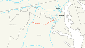
Interstate 66 (I-66) is an Interstate Highway in the eastern United States. As indicated by its even route number, it runs in an east–west direction. Its current western terminus is in Middletown, Virginia, at an interchange with Interstate 81;[2] its eastern terminus is in Washington, D.C., at an interchange with U.S. Route 29.[3] Because of its terminus in the Shenandoah Valley, the highway was once called the "Shenandoah Freeway."[4] Much of the route parallels U.S. Route 29 or Virginia State Route 55. Interstate 66 has no physical or historical connection to the famous U.S. Route 66 which is in a different region of the United States.
The E Street Expressway is a spur from Interstate 66 into the Foggy Bottom neighborhood of Washington, D.C.
Route description
| mi | km | |
|---|---|---|
| VA | 74.8 | 120.54 |
| DC | 1.6 | 2.57 |
| Total | 76.4 | 123.11 |
Virginia
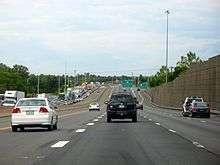
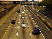
Because I-66 is the only Interstate Highway running west from Washington, D.C., into Northern Virginia, traffic on the road is often extremely heavy. For decades, there has been talk of widening I-66 from 2 to 3 lanes each way inside the Capital Beltway (Interstate 495) through Arlington, Virginia, although many Arlington residents are adamantly opposed to this plan.
In 2005, the Virginia Department of Transportation (VDOT) studied the prospect of implementing a one-lane-plus-shoulder extension on westbound I-66 within the Beltway (in an attempt to reduce congestion for people commuting away from D.C.).[5]
In the summer of 2010, construction began on a third lane and a 12-foot shoulder lane between the Fairfax Drive entrance ramp (near George Mason Drive in Ballston) to I-66 west and the Sycamore Street ramp, a 1.9 mile distance. The entrance ramp acceleration lane and the exit ramp deceleration lanes were lengthened to form a continuous lane between both ramps. The 12-foot shoulder lane can carry emergency vehicles and can be used in emergency situations. This project was completed in December 2011.[6]
The Orange Line and the Silver Line of the Washington Metro operate in the median of the highway in Fairfax and Arlington counties. Four stations (Vienna, Dunn Loring, West Falls Church, and East Falls Church) are located along this segment of I-66.
I-66 east has two exit ramps, one from each side of the highway, to the Inner Loop of I-495 heading northbound. One is a two lane right exit which merges down to one lane halfway along the ramp, while a second exit ramp is a left exit; the latter reserved for use by high-occupancy vehicle (HOV) traffic during morning rush hour, but open to all traffic excluding trucks at all other times. Both exit ramps for the Inner Loop merge prior to merging from the left with the Inner Loop. There is no access from the Outer Loop of I-495 to I-66 east; traffic wishing to make this movement must use State Route 267 east.
I-66 east also has two exits, one from each side of the highway, to the Outer Loop of I-495. One is a right exit, while one is a left exit; the latter shares a ramp with the exit to the Inner Loop of I-495.
I-66 is named the "Custis Memorial Parkway" east of the Capital Beltway in Virginia.[7] The name commemorates the Custis family, several of whose members (including Martha Dandridge Custis Washington, George Washington Parke Custis, Eleanor (Nellie) Parke Custis Lewis and Mary Anna Randolph Custis Lee) played prominent roles in Northern Virginia's history.
HOV designation and rules
Due to heavy commuter traffic, I-66 features a variety of high-occupancy vehicle (HOV) restrictions. Between US 29 in Gainesville, Virginia and the Capital Beltway, the left lane on eastbound I-66 is reserved for vehicles with two or more occupants (HOV-2 traffic) from 5:30 to 9:30 a.m. on weekdays, and the left lane on westbound I-66 is reserved for HOV-2 traffic from 3:00 to 7:00 p.m on weekdays. The eastbound shoulder lane (far right lane) between US 50 in Fairfax, Virginia and the Beltway is open to all traffic from 5:30 to 11:00 a.m on weekdays. The westbound shoulder lane (far right lane), also between the Capital Beltway and U.S. Route 50, is open to all traffic from 2:00 to 8:00 p.m on weekdays.[8]
Between the Beltway and the Theodore Roosevelt Bridge, the entire eastbound (inbound) roadway is reserved for HOV-2 and Washington Dulles International Airport traffic from 6:30 to 9:00 a.m., and the entire westbound (outbound) roadway is reserved for HOV-2 and Dulles Airport traffic from 4:00 to 6:30 p.m. This is enforced by random police presence on the on- and off-ramps, because single-passenger vehicles are allowed to enter the highway inside the Beltway in the direction of rush-hour traffic when they intend to use the Dulles Access Road at exit 67. Police heavily monitor the three-mile stretch between the Dulles Access Road and the Beltway for violations, frequently having traffic slow down to visually inspect inside each vehicle.[9]
Both motorcycles and qualified "clean special fuel" vehicles are permitted to use HOV-2 facilities on I-66 during times when HOV regulations are in effect even without the required number of occupants. The "clean special fuel" designation is used primarily by hybrid vehicles, but is also available for vehicles using alternative fuels such as natural gas or electricity.[10] To qualify for the HOV exemption, a vehicle owner must specifically request the designation when registering the vehicle, pay the appropriate fees, and display a "clean special fuel" license plate. The clean-fuel exemption is scheduled to expire on June 30, 2012, although the Virginia General Assembly has extended the exemption every year, one year at a time, since it was originally designated to expire in 2006.[11] In 2011, the exemption was modified so it applies only to clean fuel vehicles registered before June 30, 2011. Clean-fuel vehicles registered after that date are not exempt from HOV regulations on I-66. In 2012, the exemption was modified to be "open-ended" rather than year-to-year.[12]
As of January 28, 2011, penalties for HOV violators range from $125 on the first offense to $250 on the second offense, $500 on the third offense, and $1,000 on the fourth offense. Violators also receive three points on their driving record on the second and later offenses.[13]
_and_the_Orange_and_Silver_lines_of_the_Washington_Metro_from_Patrick_Henry_Drive_in_Arlington_County%2C_Virginia_while_an_eastbound_train_is_approaching.jpg)
_from_Scott_Street_in_Arlington_County%2C_Virginia.jpg)
Interstate 66 Outside the Beltway Improvement Project
The Virginia Department of Transportation (VDOT) Transportation planning board has added I-66 HOT lanes to their list of priority projects for the I-66 corridor.[14] The project has sparked opposition between residents and community businesses over the direction of this region's future infrastructure planning. The VDOT set up a website Transform 66 on regional traffic issues, and residents on the I-66 corridor set up Transform 66 Wisely, a website with local community impacts as a result of the VDOT project. Many local business groups and Chambers of Commerce located near the affected areas voiced support for transportation improvements in the I-66 region.[15]
Residents along the I-66 corridor such as Arlington County have resisted I-66 widening proposals for a long time.[16] The local Stenwood Elementary School would lose its attached field, leaving it with blacktop-only recess space.[17] In an April 16, 2015, letter to the Virginia Secretary of Transportation, members of the 1st, 8th, 10th, and 11th districts of Congress wrote that VDOT research noted that during peak hours, 35% of eastbound cars and 50% of westbound cars are HOV violators.
Future federal steps for VDOT include NEPA review, obligation of federal funds, certification that the conversion to tolled facilities will not "degrade" the existing facility, and potential federal loan guarantee. The Virginia Commonwealth Transportation Board (CTB) is responsible for overseeing VDOT and allocating highway funding to specific projects. The board has 18 members appointed by the Governor [18] and includes the Virginia Secretary of Transportation, Aubrey Layne, and is the group that will be making the final decision and allocating funding for VDOT’s plans for I-66.
District of Columbia
In Washington, D.C., I-66 follows the West Leg of the Inner Loop freeway. After crossing the Potomac River on the Theodore Roosevelt Bridge concurrent with US 50, the route quickly turns north, separating from US 50. The highway interchanges with the E Street Expressway spur before passing beneath Virginia Avenue in a short tunnel. After an indirect interchange with the Rock Creek Parkway (via 27th Street), the highway terminates at a pair of ramps leading to the Whitehurst Freeway (US 29) and L Street.[19]
This is the only 2 digit Interstate to enter the District of Columbia on land. I-95 crosses DC waters for approximately 100 yards (91 m) along on the Woodrow Wilson Bridge (part of the Capital Beltway).
E Street Expressway
The E Street Expressway is a spur of I-66 that begins at an interchange with the interstate just north of the Roosevelt Bridge. It proceeds east, has an interchange with Virginia Avenue NW, and terminates at 20th Street NW. From there, traffic continues along E Street NW to 17th Street NW near the White House, the Old Executive Office Building, and the Corcoran Gallery of Art. Westbound traffic from 17th Street takes a one-block segment of New York Avenue to the expressway entrance at 20th and E Streets NW. The expressway and the connecting portions of E Street and New York Avenue are part of the National Highway System.
- Exit list
The entire route is in Washington, D.C.
| mi[20] | km | Destinations | Notes | ||
|---|---|---|---|---|---|
| 0.00 | 0.00 | Western terminus; No trucks to I-66 west | |||
| 0.09 | 0.14 | Virginia Avenue / 23rd Street | Eastbound exit only | ||
| 0.13– 0.30 | 0.21– 0.48 | Tunnel underneath Virginia Avenue | |||
| 0.39 | 0.63 | 20th Street / E Street east | Eastern terminus at an at-grade intersection | ||
| 1.000 mi = 1.609 km; 1.000 km = 0.621 mi | |||||
History
Virginia
As with many urban Interstate Highway projects, I-66 has encountered opposition from local citizen groups.
_from_northbound_Glebe_Road_(Virginia_State_Route_120)_in_Arlington_County%2C_Virginia.jpg)
Most notably for I-66 was the construction through Arlington, Virginia, proposed in 1956. After the Virginia Department of Transportation (VDOT) (then known as the Virginia Department of Highways) acquired two sections of the former route of the Washington and Old Dominion Railroad to provide a right-of-way through Arlington for the new highway, the Arlington Coalition on Transportation (ACT) filed a lawsuit in Federal District Court in 1971 opposing the Arlington portion of the project. The group objected to that urban segment due to concerns over air quality, noise and community cohesion changes. In 1972 the U.S. Fourth Circuit Court of Appeals ruled in favor of ACT, technically blocking any construction. The U.S. Supreme Court upheld the ruling in favor of ACT later in 1972.[21]
In July 1974, a final environmental impact statement (EIS) was submitted.[22] The EIS proposed an eight-lane limited access expressway from the Capital Beltway to the area near Spout Run Parkway.[22] Six lanes would branch off at the Parkway and cross the Potomac River via a proposed Three Sisters Bridge.[22] Another six lanes would branch off to the Theodore Roosevelt Bridge.[22] In November, a modified design was submitted, reducing the eight lanes to six. However, in 1977, VDOT disapproved the six-lane design.[22]
The parties then agreed on experts to conduct air quality and noise studies for VDOT, selecting the firm of ESL Inc., the expert hired originally by ACT. In 1976, United States Secretary of Transportation William Thaddeus Coleman, Jr. intervened. On January 4, 1977, Coleman approved federal aid for a four-lane limited access highway between the Capital Beltway and the Theodore Roosevelt Bridge.[22] The highway would contain a Metrorail line in its median from Vienna, Virginia, eastward.[22][23][24]
Less controversial was the portion of the highway's route immediately west of Arlington. There, VDOT decided to curve the highway to bypass the City of Falls Church, increasing the highway's length while sparing the city from the road's immediate environmental impacts. The roadway was completed between the Capital Beltway and the Theodore Roosevelt Bridge in 1982.[22]
On October 9, 1999, Public Law 106-69 transferred from the federal government to the Commonwealth of Virginia the authority for the operation, maintenance and construction of I-66 between Rosslyn and the Capital Beltway.[25]
In Gainesville, Virginia, the Gainesville Interchange Project is taking place at and near the interchange between U.S. Route 29 (U.S. 29) and I-66, aiming to upgrade facilities for those and many other roads due to rapid development and accompanying heavy traffic in the Gainesville and Haymarket area. I-66's overpasses were reconstructed to accommodate nine lanes (six general purpose, two HOV, one collector-distributor eastbound) and lengthened for the expansion of U.S. 29 to six lanes. These alterations were completed in June 2010. US 29 is also planned to be largely grade-separated in the area, including an interchange at its current intersection with SR 619 (Linton Hall Road); land for this has been acquired. The project overall began in 2004 and completion is slated for late 2014.[26]
District of Columbia
.svg.png)

In Washington D.C., I-66 was planned to extend east of its current terminus along the North Leg of the Inner Loop freeway. I-66 would have also met the eastern terminus of a planned Interstate 266 at US 29, and the western terminus of the South Leg Freeway (I-695) at US 50; I-266 would have been a parallel route to I-66, providing more direct access to the North Leg from points west, while I-695 would have been an inner-city connector between I-66 and I-95.
The final plans for the North Leg Freeway, as published in 1971, outlined a 1.5-mile (2.4 km) six-lane tunnel beneath K Street, between I-266/US 29 and New York Avenue, where the North Leg would emerge from the tunnel and join with the Center Leg Freeway (formerly I-95, now I-395); the two routes would run concurrently for three-fourths of a mile before reaching the Union Station interchange, where I-66 was planned to terminate. Despite the plan to route the North Leg in a tunnel beneath K Street, the intense opposition to previous, scrapped alignments for the D.C. freeway network, which included previous alignments for the North Leg Freeway, led to the mass cancellation of all unbuilt D.C. freeways in 1977, resulting in the truncation of I-66 at US 29.
Exit list
All exits in the District of Columbia are unnumbered.
| State | County | Location | mi[27] | km | Old exit | New exit | Destinations | Notes |
|---|---|---|---|---|---|---|---|---|
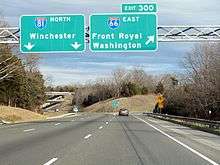
| Virginia | Frederick | Strasburg | 0.0 | 0.0 | 1 | 1 | Signed as exits 1A (south) and 1B (north); I-81 exit 300 | |
| Warren | Front Royal | 6.4 | 10.3 | 2 | 6 | |||
| | 12.9 | 20.8 | 3 | 13 | ||||
| Fauquier | Markham | 18.5 | 29.8 | 4 | 18 | |||
| Delaplane | 23.3 | 37.5 | 5 | 23 | West end of US 17 / SR 55 overlap | |||
| | 27.0 | 43.5 | 6 | 27 | East end of SR 55 overlap; former SR 242 south | |||
| | 28.3 | 45.5 | 7 | 28 | East end of US 17 overlap | |||
| | 31.3 | 50.4 | 8 | 31 | ||||
| Prince William | Haymarket | 40.5 | 65.2 | 9 | 40 | Interchange under construction. | ||
| Gainesville | 43.1 | 69.4 | 10 | 43 | Signed as exits 43A (south) and 43B (north) | |||
| | 44.5 | 71.6 | 11 | 44 | West end of SR 234 overlap | |||
| | 47.3 | 76.1 | 12 | 47 | East end of SR 234 overlap; signed as exits 47A (south) and 47B (north) westbound | |||
| | 48.8 | 78.5 | Rest area | |||||
| Fairfax | Centreville | 52.1 | 83.8 | 13 | 52 | |||
| 53.2 | 85.6 | 14 | 53 | No access from I-66 east to SR 28 south or SR 28 north to I-66 west; signed as 53A (south) and 53B (north) westbound | ||||
| Fair Lakes | 54.9 | 88.4 | Stringfellow Road (SR 645) | Westbound exit and eastbound entrance (one-way reversible HOV ramp)[28] | ||||
| 55.9 | 90.0 | 15 | 55 | Signed as exits 55A (south) and 55B (north) | ||||
| Fair Oaks | 57.1 | 91.9 | Monument Drive (SR 6751) | Westbound exit and eastbound entrance (two-way HOV ramp)[28] | ||||
| 58.1 | 93.5 | 16 | 57 | Signed as exits 57A (east) and 57B (west) | ||||
| Oakton | 60.1 | 96.7 | 17 | 60 | ||||
| 61.6 | 99.1 | Eastbound exit and westbound entrance via SR 243 interchange ramps | ||||||
| 62.5 | 100.6 | 17A | 62 | |||||
| | 65.1 | 104.8 | 18 | 64 | Signed as exits 64A (south) and 64B (north) eastbound; no direct access from I-66 west to I-495 north or I-495 south to I-66 east; I-495 exit 49 | |||
| | 65.1 | 104.8 | no access from I-66 west to I-495 Express north or I-495 Express south to I-66 east | |||||
| | 66.0 | 106.2 | 19 | 66 | Signed as exits 66A (east) and 66B (west) westbound | |||
| | 66.6 | 107.2 | 20 | 67 | Westbound exit and eastbound entrance | |||
| Arlington | West Arlington | 67.8 | 109.1 | 21 | 68 | Westmoreland Street | Eastbound exit and westbound entrance | |
| East Falls Church | 68.4 | 110.1 | 22 | 69 | Eastbound exit and westbound entrance | |||
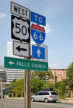
| 23 | 69 | Sycamore Street – Falls Church | Westbound exit and eastbound entrance | |||||
| Ballston | 70.5 | 113.5 | 24 | 71 | ||||
| | 72.1 | 116.0 | 25 | 72 | Eastbound exit and westbound entrance | |||
| Rosslyn | 73.1 | 117.6 | 26 | 73 | ||||
| 74.2 | 119.4 | 27 | 75 | Eastbound exit and westbound entrance | ||||
| 74.5 | 119.9 | West end of US 50 overlap; westbound exit and eastbound entrance | ||||||
| Potomac River | 74.8 0.0 | 120.4 0.0 | Theodore Roosevelt Bridge | |||||
| District of Columbia | Washington | 0.5 | 0.80 | Independence Avenue / Maine Avenue | ||||
| East end of US 50 overlap; eastbound exit and westbound entrance | ||||||||
| 0.7 | 1.1 | E Street Expressway east | Western terminus of the E Street Expressway | |||||
| 1.2 | 1.9 | Rock Creek Parkway | Eastbound exit and westbound entrance | |||||
| 1.3 | 2.1 | Pennsylvania Avenue Northwest | Eastbound exit only | |||||
| 1.6 | 2.6 | Whitehurst Freeway (US 29 south) / Canal Road | ||||||
1.000 mi = 1.609 km; 1.000 km = 0.621 mi
| ||||||||
Auxiliary routes
| |
|---|---|
| Location: | Arlington, Virginia–Washington DC |
| Existed: | 1960s–1972 |
Interstate 266 (I-266) was a proposed loop route of I-66 between Washington, D.C., and Arlington County, Virginia. District of Columbia officials proposed designating the route Interstate 66N, a move opposed by the American Association of State Highway and Transportation Officials. In Virginia, Interstate 266 would have split off from Interstate 66 just east of the present Spout Run Parkway exit. From there, it would have followed an expanded Spout Run Parkway, crossed the George Washington Memorial Parkway, and crossed the Potomac River across a new bridge that would have been called the Three Sisters Bridge. Upon entering the District of Columbia, it would have followed Canal Road and an expanded Whitehurst Freeway to rejoin Interstate 66 at K Street. Interstate 266 was canceled in 1972 in the face of community opposition during Washington's "freeway revolts".[29][30]
References
- ↑ "Table 1: Main Routes of the Dwight D. Eisenhower National System of Interstate and Defense Highways as of October 31, 2002". Route Log and Finder List. Federal Highway Administration.
- ↑ Google (June 8, 2009). "Interstate 66" (Map). Google Maps. Google. Retrieved June 8, 2009.
- ↑ Google (June 8, 2009). "Interstate 66" (Map). Google Maps. Google. Retrieved June 8, 2009.
- ↑ http://www.fairfaxcounty.gov/dpz/comprehensiveplan/planhistoric/1984_documents/1984_transportation.pdf
- ↑ Shaffer, Ron (October 21, 2005). "Dr. Gridlock". Washington Post.
- ↑ "I-66 Spot Improvements-Spot 1". Virginia Department of Transportation. August 25, 2011.
- ↑ "Arlington Virginia List of State Roads". Environmental Services. Government of Arlington County, Virginia. Archived from the original on March 4, 2006. Retrieved February 25, 2013.
- ↑ "HOV Lanes: Northern Virginia HOV Operating Hours". VDOT Travel Center. Retrieved December 4, 2008.
- ↑ Weiss, Eric M. (June 16, 2008). "When 'Airport Business' Is a Ticket to Less Traffic; Loophole Gives Drivers Shortcut Through Dulles for Access Road Commute". The Washington Post. p. A1.
- ↑ Virginia DMV: Clean Special Fuel Vehicles/Plates Retrieved on May 21, 2009
- ↑ Thomson, Robert (March 6, 2011). "Hybrids stay in Virginia HOV lanes". The Washington Post. Retrieved May 14, 2011..
- ↑ New Law for Hybrids on HOV Lanes Signed by Gov. McDonnell May 2012 Retrieved May 31, 2012
- ↑ "High Occupancy Vehicle (HOV) Lanes: Rules and FAQs". Virginia Department of Transportation. Retrieved January 29, 2013.
- ↑ Thomson, Robert (February 18, 2015). "I-66 HOT lanes plan reviewed by regional panel". The Washington Post. Retrieved May 10, 2015.
- ↑ "Commentary: Business groups urge action on I-66 outside the Beltway". INSIDENOVA.COM.
- ↑ "Officials to consider road widening, HOT lanes through Arlington portion of I-66". Washington Post.
- ↑ "Deal close to save homes from I-66 widening". WTOP.
- ↑ "CTB Member Roll" (PDF).
- ↑ The 2014 Road Atlas (Map). Rand McNally. 2014. p. 111.
- ↑ "Google Maps". Google. Retrieved April 2, 2013.
- ↑ Mathews, Jay (November 7, 1972). "High Court Backs Delay of Rte. 66". The Washington Post.
- 1 2 3 4 5 6 7 8 "Background: I-66 History". Idea-66. Virginia Department of Transportation. Archived from the original on January 23, 2012. Retrieved February 25, 2013.
- ↑ "An Abridged I-66 Chronology". The Arlington Coalition for Sensible Transportation. Retrieved February 5, 2006.
- ↑ Hogan, C. M. & Seidman, Harry (1971). Air Quality and Acoustics Analysis of Proposed I-66 through Arlington, Virginia. Sunnyvale, CA: ESL Inc. Technical Document T1026.
- ↑ "Department of Transportation and Related Agencies Appropriations Act, 2000: Public Law 106-69: 106th Congress" (pdf). Sec. 357. United States Government Printing Office. October 9, 1999. p. 113 Stat. 1027. Retrieved February 25, 2013.
Sec. 357. (a) Notwithstanding the January 4, 1977, decision of the Secretary of Transportation that approved construction of Interstate Highway 66 between the Capital Beltway and Rosslyn, Virginia, the Commonwealth of Virginia, in accordance with existing Federal and State law, shall hereafter have authority for operation, maintenance, and construction of Interstate Route 66 between Rosslyn and the Capital Beltway, except as noted in paragraph (b).
(b) The conditions in the Secretary's January 4, 1997 decision, that exclude heavy duty trucks and permit use by vehicles bound to or from Washington Dulles International Airport in the peak direction during peak hours, shall remain in effect. - ↑ "Gainesville Interchange Project". 2011. Retrieved July 4, 2011.
- ↑ Google (December 26, 2013). "Interstate 66 in Washington, D.C." (Map). Google Maps. Google. Retrieved December 26, 2013.
- 1 2 "I-66 West HOV Ramps Now Open Off-Peak and Weekends" (Press release). February 28, 2011. Retrieved February 28, 2011.
- ↑ Archived August 4, 2011, at the Wayback Machine.
- ↑ "3-digit Interstates from I-66". Kurumi.com. Retrieved January 29, 2013.
External links
| Wikimedia Commons has media related to Interstate 66. |
- HOV schedule in Northern Virginia, from Virginia Dept. of Transportation
- Roads to the Future: Washington D.C. Interstates and Freeways
- Steve Anderson's DCRoads.net: Interstate 66 (Virginia)
| Signed | |||||||||||
|---|---|---|---|---|---|---|---|---|---|---|---|
| Unsigned | |||||||||||
| Lists |
| ||||||||||
Major Interstates highlighted | |||||||||||
| Browse numbered routes | ||||
|---|---|---|---|---|
| ← | VA | SR 67 | ||
| ← | DC | I‑95 | ||