Interstate 12
| ||||
|---|---|---|---|---|
| Republic of West Florida Parkway | ||||
_map.svg.png) | ||||
| Route information | ||||
| Maintained by Louisiana DOTD | ||||
| Length: | 85.59 mi[1] (137.74 km) | |||
| Existed: |
1957 (planned); 1967 (first section opened); 1976 (completed) – present | |||
| Major junctions | ||||
| West end: |
| |||
|
| ||||
| East end: |
| |||
| Location | ||||
| Parishes: | East Baton Rouge, Livingston, Tangipahoa, St. Tammany | |||
| Highway system | ||||
| ||||

Interstate 12 (I-12) is an Interstate Highway located entirely within the U.S. state of Louisiana. It spans a total of 85.59 miles (137.74 km) in an east–west direction from I-10 in Baton Rouge to an interchange with both I-10 and I-59 in Slidell.[1][2] Along the way, it passes through the city of Hammond, where it intersects I-55 and US 51. It also serves the smaller cities of Denham Springs and Ponchatoula, as well as the St. Tammany Parish cities of Covington and Mandeville. Skirting the northern shore of Lake Pontchartrain, I-12 serves as a northern bypass of the New Orleans metropolitan area and as an alternate route for I-10, which serves the city of New Orleans itself.
I-12 parallels the older US 190 corridor and traverses the North Shore of Lake Pontchartrain in the southeastern portion of the state. The interstate's length is short for a mainline interstate and is comparable with the country's longest auxiliary interstates. It is one of the shortest mainline interstates to terminate at the same route (I-10) at either end. Apart from serving the various communities of the North Shore, I-12 acts as a long bypass of New Orleans and is heavily used as a shortcut for through traffic on I-10. While I-10 curves to the south to pass through the city limits, I-12 takes a more direct alignment, reducing the distance between Baton Rouge and Slidell by about 22 miles (35 km).
In 1993, the Louisiana state legislature designated I-12 as the Republic of West Florida Parkway. In 2003, signs identifying the highway's official name and bearing the flag of the Republic of West Florida were erected by the Louisiana Department of Transportation and Development (LADOTD) in order to highlight the unique history of Louisiana's Florida Parishes.
Louisiana is in the process of widening I-12 to three lanes in locations where the interstate is still two lanes in each direction.
Route description
Baton Rouge to Hammond
From the west, I-12 begins three miles east of downtown Baton Rouge in East Baton Rouge Parish at an interchange with I-10 known as the I-10/I-12 split. While I-10 heads to the southeast toward the New Orleans metropolitan area, I-12 proceeds eastward toward the North Shore of Lake Pontchartrain. Before leaving Baton Rouge, I-12 intersects some of its major arteries, including LA 3064 (Essen Lane) and LA 73 (Jefferson Highway) via LA 1068 (Drusilla Lane). It then passes through a cloverleaf interchange with US 61 (Airline Highway). These three exits serve several of the area's key medical and shopping centers, such as the Our Lady of the Lake Regional Medical Center and Cortana Mall. The final exit in Baton Rouge is an interchange with LA 3245 (O'Neal Lane), which serves the Ochsner Medical Center and eastern suburbs.[2][3][4]
1.3 miles (2.1 km) later, I-12 reaches the Amite River, where it enters Livingston Parish and the city of Denham Springs. I-12 skirts the southern edge of town, providing interchanges with LA 3002 (South Range Avenue) and LA 1026 (Juban Road). East of Denham springs, I-12 skirts the southern edge of Livingston Parish's only other city, Walker. The interstate's sole exit in Walker is Exit 15, an interchange with LA 447.
Past Walker are smaller communities in the eastern half of the parish. Exits include: LA 63 serving Livingston (Exit 22), LA 441 serving Holden (Exit 29), and LA 43 serving Albany and Springfield (Exit 32).[2][5][6]
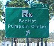
Shortly after crossing the Natalbany River into Tangipahoa Parish, I-12 intersects LA 1249, which leads to the communities of Baptist and Pumpkin Center. 3.2 miles (5.1 km) later, I-12 enters into a cloverleaf interchange with I-55 at the southeast corner of Hammond, the largest city in Tangipahoa Parish. I-55 heads toward Jackson, Mississippi on the north and New Orleans on the south. A mile after, US 51 crosses I-12, but the two roads do not intersect. There is instead an interchange with US 51 Business, which serves downtown Hammond, as well as the city of Ponchatoula to the south.[2][6][7]
Hammond to Slidell
East of Hammond are two rural exits in southeastern Tangipahoa Parish: LA 3158 (Airport Road) to the Hammond Northshore Regional Airport, and LA 445 to Robert.
Just after crossing into St. Tammany Parish, I-12 curves to the southeast and begins to parallel the North Shore of Lake Pontchartrain. An interchange with LA 1077 serves the town of Madisonville to the south. The following exit, an interchange with LA 21, also connects to Madisonville as well as the parish seat of Covington to the north. Immediately before crossing the Tchefuncte River, an exit to Pinnacle Parkway and East Brewster Road serves the growing shopping area east of LA 21.
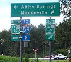
2.0 miles (3.2 km) east of the bridge, I-12 passes through an interchange with US 190 between Covington and Mandeville. This section of US 190 serves as St. Tammany's busiest north–south thoroughfare, connecting Covington and surrounding points with the Lake Pontchartrain Causeway, a 24 miles (39 km)-long bridge leading to New Orleans. Further exits in St. Tammany Parish west of Slidell include LA 59 to Mandeville and Abita Springs, LA 1088 to LA 36, and LA 434 to Lacombe.[2][6][8]
6.3 miles (10.1 km) east of the Lacombe exit, I-12 passes through an interchange with Airport Drive, which connects to Slidell Airport due north. At this exit, I-12 enters the northern edge of Slidell. An interchange with US 11 connects to the downtown area. Less than 2.0 miles (3.2 km) later, I-12 reaches its eastern terminus at a major interchange with I-10 and I-59 at the northeast corner of town. From this interchange, I-10 heads southwest toward New Orleans and east toward Bay St. Louis, Mississippi while I-59 heads north toward Hattiesburg, Mississippi.[2][6][9]
History
Interstate 12 was added to the highway system on October 17, 1957, with I-12 running from I-10 in Baton Rouge to I-59 north of Slidell.[10] By the mid-1960s, the routes had been realigned to their current configuration, with I-12 and I-59 both ending at I-10 near Slidell.[11] The route was opened to traffic in several sections between January 1967 and June 1976.[12][13]
With major damage to the I-10 Twin Span Bridge across Lake Pontchartrain from Hurricane Katrina, I-12 was temporarily functioning as Interstate 10 between Baton Rouge and Slidell. On October 14, 2005, the eastbound span of I-10 over Lake Pontchartrain reopened to two-way traffic. The westbound span of I-10 reopened on January 6, 2006, with speed, weight and size restrictions, relieving I-12 of much of the congestion that was clogging it from the Lake Pontchartrain Causeway to the junction with I-10 and I-59.
LA DOTD widened the interstate to three lanes in each direction from O'neal Lane (Exit 7) to Juban Road (Exit 12) in 2012, later extending to Exit 15 (Walker South Road/LA 447) in 2013 and ½ west of Satsuma (Exit 19) in 2015. In St. Tammany Parish, near Slidell, a third lane was added from the I-10/I-12/I-59 split to just west of US 11 in 2012 and to Airport Drive/Northshore Boulevard (Exit 80) in 2016.
The I-10/I-12/I-59 split, notorious for rough pavement, was repaved in 2015.
Future
LA DOTD will widen I-12 to three lanes in the Covington area from US 190 (Exit 63) to LA 59 (Exit 65) in 2016, and it will do the same between LA 21 (Exit 59) and US 190 in 2018[14]
Exit list
| Parish | Location | mi[2] | km | Exit | Destinations | Notes |
|---|---|---|---|---|---|---|
| East Baton Rouge | Baton Rouge | 0.0 | 0.0 | – | Western terminus | |
| 0.8 | 1.3 | 1A | Exit 159 on I-10 | |||
| 1.2– 1.5 | 1.9– 2.4 | 1B | No westbound exit | |||
| 2.1 | 3.4 | 1C | Westbound exit and eastbound entrance | |||
| 2.6– 3.1 | 4.2– 5.0 | 2 | Signed as exit 2A (south) and 2B (north); to Hammond Aire Plaza and Mall at Cortana | |||
| 3.8– 4.3 | 6.1– 6.9 | 4 | Sherwood Forest Boulevard | |||
| 5.7– 6.4 | 9.2– 10.3 | 6 | Millerville Road | |||
| 6.8– 7.3 | 10.9– 11.7 | 7 | ||||
| East Baton Rouge– Livingston line | Denham Springs | 8.3– 8.8 | 13.4– 14.2 | Bridge over Amite River | ||
| Livingston | 10.0– 10.5 | 16.1– 16.9 | 10 | |||
| | 12.4– 12.9 | 20.0– 20.8 | 12 | |||
| Walker | 15.6– 16.2 | 25.1– 26.1 | 15 | |||
| | 19.6– 20.1 | 31.5– 32.3 | 19 | |||
| Livingston | 22.5– 23.1 | 36.2– 37.2 | 22 | |||
| | 28.8– 29.3 | 46.3– 47.2 | 29 | |||
| Hungarian Settlement | 32.6– 33.2 | 52.5– 53.4 | 32 | |||
| Tangipahoa | | 34.7– 35.4 | 55.8– 57.0 | 35 | ||
| Hammond | 37.9– 38.5 | 61.0– 62.0 | 38 | Signed as exit 38A (south) and 38B (north); I-55 exits 29A-B | ||
| 39.9– 40.4 | 64.2– 65.0 | 40 | ||||
| | 42.4– 42.9 | 68.2– 69.0 | 43 | Southern terminus of LA 3158; to Hammond Northshore Regional Airport | ||
| | 47.5– 47.8 | 76.4– 76.9 | 47 | |||
| St. Tammany | | 56.8– 57.4 | 91.4– 92.4 | 57 | ||
| | 59.1– 59.8 | 95.1– 96.2 | 59 | |||
| | 60.1– 60.7 | 96.7– 97.7 | 60 | Pinnacle Parkway, East Brewster Road | ||
| | 60.8– 61.0 | 97.8– 98.2 | Bridge over Tchefuncte River | |||
| | 62.5– 63.3 | 100.6– 101.9 | 63 | Signed as exit 63A (east) and 63B (west), to Lake Pontchartrain Causeway | ||
| | 65.5– 66.1 | 105.4– 106.4 | 65 | |||
| | 68.0– 68.8 | 109.4– 110.7 | 68 | |||
| Lacombe | 73.8– 74.4 | 118.8– 119.7 | 74 | |||
| Slidell | 80.1– 80.7 | 128.9– 129.9 | 80 | Airport Drive, North Shore Boulevard | To Slidell Airport | |
| 83.5– 83.7 | 134.4– 134.7 | 83 | ||||
| 85.2– 86.2 | 137.1– 138.7 | 85 | Eastern terminus; signed as exit 85A (I-10 west), 85B (I-59), and 85C (I-10 east), exit 267B on I-10 and 1C on I-59; Southern Terminus of I-59 | |||
| 1.000 mi = 1.609 km; 1.000 km = 0.621 mi | ||||||
See also
 Louisiana portal
 U.S. Roads portal
References
- 1 2 Staff (October 31, 2002). "Table 1: Main Routes of the Dwight D. Eisenhower National System Of Interstate and Defense Highways as of October 31, 2002". Route Log and Finder List. Federal Highway Administration. Retrieved June 5, 2013.
- 1 2 3 4 5 6 7 Google (June 12, 2013). "Overview Map of I-12" (Map). Google Maps. Google. Retrieved June 12, 2013.
- ↑ East Baton Rouge Parish (PDF) (Map). Cartography by La DOTD Office of Multimodal Planning. Louisiana Department of Transportation and Development. February 2012. Retrieved June 13, 2013.
- ↑ District 61: Official Control Section Map / Construction and Maintenance (PDF) (Map). Cartography by La DOTD Office of Multimodal Planning. Louisiana Department of Transportation and Development. February 2012. Retrieved June 13, 2013.
- ↑ Livingston Parish (PDF) (Map). Cartography by La DOTD Office of Multimodal Planning. Louisiana Department of Transportation and Development. February 2012. Retrieved June 13, 2013.
- 1 2 3 4 District 62: Official Control Section Map / Construction and Maintenance (PDF) (Map). Cartography by La DOTD Office of Multimodal Planning. Louisiana Department of Transportation and Development. February 2012. Retrieved June 13, 2013.
- ↑ Tangipahoa Parish (South Section) (PDF) (Map). Cartography by La DOTD Office of Multimodal Planning. Louisiana Department of Transportation and Development. February 2012. Retrieved June 13, 2013.
- ↑ St. Tammany Parish (West Section) (PDF) (Map). Cartography by La DOTD Office of Multimodal Planning. Louisiana Department of Transportation and Development. February 2012. Retrieved June 13, 2013.
- ↑ St. Tammany Parish (East Section) (PDF) (Map). Cartography by La DOTD Office of Multimodal Planning. Louisiana Department of Transportation and Development. February 2012. Retrieved June 13, 2013.
- ↑ Routes to Be Added to the National System of Interstate and Defense Highways (Map). Bureau of Public Roads. October 17, 1957. Retrieved December 8, 2012.
- ↑ The National System of Interstate and Defense Highways (Map). Bureau of Public Roads. c. 1963. Retrieved December 8, 2012.
- ↑ "State Highway Work Sets All-Time Mark". The Times-Picayune. New Orleans. January 29, 1967. p. 8-11.
- ↑ "Final I-12 Link Opening Today". The Times-Picayune. New Orleans. June 25, 1976. p. 2-11.
- ↑ "Louisiana State Transportation Improvement Plan (STIP)" (PDF). Louisiana Department of Transportation and Development. July 12, 2016. Retrieved July 22, 2016.
External links
 Media related to Interstate 12 at Wikimedia Commons
- La DOTD State, District, and Parish Maps
| Signed | |||||||||||
|---|---|---|---|---|---|---|---|---|---|---|---|
| Unsigned | |||||||||||
| Lists |
| ||||||||||
Major Interstates highlighted | |||||||||||