Iatan, Missouri
| Iatan, Missouri | |
|---|---|
| Village | |
|
Iatan Power Plant | |
 Location of Iatan, Missouri | |
| Coordinates: 39°28′32″N 94°58′57″W / 39.47556°N 94.98250°WCoordinates: 39°28′32″N 94°58′57″W / 39.47556°N 94.98250°W | |
| Country | United States |
| State | Missouri |
| County | Platte |
| Area[1] | |
| • Total | 0.12 sq mi (0.31 km2) |
| • Land | 0.12 sq mi (0.31 km2) |
| • Water | 0 sq mi (0 km2) |
| Elevation | 804 ft (245 m) |
| Population (2010)[2] | |
| • Total | 45 |
| • Estimate (2012[3]) | 46 |
| • Density | 375.0/sq mi (144.8/km2) |
| Time zone | Central (CST) (UTC-6) |
| • Summer (DST) | CDT (UTC-5) |
| FIPS code | 29-34210[4] |
| GNIS feature ID | 0720068[5] |
Iatan is a village in Platte County, Missouri, United States. The population was 45 at the 2010 census.
The community is said to derive its name from Iatan, a chief of the Otoe tribe who supposedly derived his name from battles with the Comanche who were sometimes also referred to as Iatan.[6]
Iatan, first settled by John Dougherty in 1837, was one of the first communities to be established after the Platte Purchase allowed white settlement on former Native American land (which was proclaimed in February 1837). It was initially an important trading port on the Missouri River but was soon overtaken by Weston, Missouri five miles (8 km) to the south and St. Joseph, Missouri 20 miles (32 km) to the north.[7]
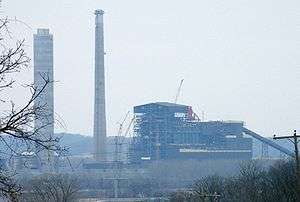
Iatan power plants
The community's name is applied to the Iatan 1 and Iatan 2 coal-fired power stations for Kansas City Power & Light which is the largest coal-fired generating plant in Missouri.[8]
The Iatan 1 plant which opened in 1980 has a 651-megawatt capacity and had a 700-foot (210 m) high chimney when it opened. The tower is higher than any occupied building in the state including the Gateway Arch.[9]
The Iatan 2 plant opened in 2010 and can generate 850 Megawatts with a capacity to burn 494 tons of coal per hour. The new plant has a lower 60-foot (18 m) high mechanical cooling tower.[10]
Geography
Iatan is located at 39°28′32″N 94°58′57″W / 39.47556°N 94.98250°W (39.475594, -94.982509).[11]
According to the United States Census Bureau, the village has a total area of 0.12 square miles (0.31 km2), all of it land.[1]
Demographics
| Historical population | |||
|---|---|---|---|
| Census | Pop. | %± | |
| 1870 | 129 | — | |
| 1880 | 117 | −9.3% | |
| 1970 | 75 | — | |
| 1980 | 64 | −14.7% | |
| 1990 | 47 | −26.6% | |
| 2000 | 54 | 14.9% | |
| 2010 | 45 | −16.7% | |
| Est. 2015 | 47 | [12] | 4.4% |
2010 census
As of the census[2] of 2010, there were 45 people, 18 households, and 11 families residing in the village. The population density was 375.0 inhabitants per square mile (144.8/km2). There were 22 housing units at an average density of 183.3 per square mile (70.8/km2). The racial makeup of the village was 91.1% White, 6.7% African American, and 2.2% from two or more races.
There were 18 households of which 27.8% had children under the age of 18 living with them, 44.4% were married couples living together, 11.1% had a female householder with no husband present, 5.6% had a male householder with no wife present, and 38.9% were non-families. 27.8% of all households were made up of individuals and 16.7% had someone living alone who was 65 years of age or older. The average household size was 2.50 and the average family size was 3.18.
The median age in the village was 35.8 years. 26.7% of residents were under the age of 18; 6.6% were between the ages of 18 and 24; 26.7% were from 25 to 44; 28.8% were from 45 to 64; and 11.1% were 65 years of age or older. The gender makeup of the village was 55.6% male and 44.4% female.
2000 census
As of the census[4] of 2000, there were 54 people, 22 households, and 13 families residing in the village. The population density was 1,399.0 people per square mile (521.2/km²). There were 24 housing units at an average density of 621.8 per square mile (231.7/km²). The racial makeup of the village was 100.00% White.
There were 22 households out of which 31.8% had children under the age of 18 living with them, 40.9% were married couples living together, 13.6% had a female householder with no husband present, and 40.9% were non-families. 31.8% of all households were made up of individuals and 4.5% had someone living alone who was 65 years of age or older. The average household size was 2.45 and the average family size was 3.31.
In the village the population was spread out with 24.1% under the age of 18, 7.4% from 18 to 24, 27.8% from 25 to 44, 31.5% from 45 to 64, and 9.3% who were 65 years of age or older. The median age was 40 years. For every 100 females there were 100.0 males. For every 100 females age 18 and over, there were 105.0 males.
The median income for a household in the village was $35,625, and the median income for a family was $36,250. Males had a median income of $22,188 versus $10,625 for females. The per capita income for the village was $8,895. There were 25.0% of families and 16.4% of the population living below the poverty line, including 15.6% of under eighteens and none of those over 64.
References
- 1 2 "US Gazetteer files 2010". United States Census Bureau. Retrieved 2012-07-08.
- 1 2 "American FactFinder". United States Census Bureau. Retrieved 2012-07-08.
- ↑ "Population Estimates". United States Census Bureau. Retrieved 2013-05-30.
- 1 2 "American FactFinder". United States Census Bureau. Retrieved 2008-01-31.
- ↑ "US Board on Geographic Names". United States Geological Survey. 2007-10-25. Retrieved 2008-01-31.
- ↑ Native American Placenames of the United States by William Bright - University of Oklahoma Press - 2007 ISBN 0-8061-3598-0
- ↑ A Directory of Towns, Villages, and Hamlets Past and Present of Platte County, Missouri Compiled by Arthur Paul Moser - the library.org
- ↑ Kansas City Power & Light Awards Iatan 2 Power Plant Project to Burns & McDonnell - Great Plains Energy Press Release - December 8, 2005
- ↑ Iatan Power Plant - Skyscraperpage.com
- ↑ US Army Corp of Engeineers Report on Permit No. 200200121 - January 20, 2006
- ↑ "US Gazetteer files: 2010, 2000, and 1990". United States Census Bureau. 2011-02-12. Retrieved 2011-04-23.
- ↑ "Annual Estimates of the Resident Population for Incorporated Places: April 1, 2010 to July 1, 2015". Retrieved July 2, 2016.
- ↑ "Census of Population and Housing". Census.gov. Retrieved June 4, 2015.
Municipalities and communities of Platte County, Missouri, United States | ||
|---|---|---|
| Cities |  | |
| Villages | ||
| Townships |
| |
| Unincorporated communities |
| |
| Footnotes | ‡This populated place also has portions in an adjacent county or counties | |