U.S. Route 52 in West Virginia
| ||||
|---|---|---|---|---|
_map.svg.png) | ||||
| Route information | ||||
| Maintained by WVDOH | ||||
| Existed: | 1926 – present | |||
| Major junctions | ||||
| South end: |
| |||
| North end: |
| |||
| Highway system | ||||
| ||||

U.S. Route 52 (US 52) skirts the western fringes of the U.S. state of West Virginia. It runs from the Virginia state line near Bluefield, where it is concurrent with Interstate 77 (I-77), in a general northwest and north direction to I-64 at Kenova. There it turns east, overlapping I-64 for five miles (8.0 km) before splitting off onto the West Huntington Expressway into Ohio via the West Huntington Bridge. Despite having an even number, US 52 is signed north–south in West Virginia. In some other states along its route, it is signed east-west. The West Virginia segment is signed such that US 52 north corresponds to the general westward direction of the highway, and vice versa.
Most of the route is being upgraded to a high-speed four-lane divided highway, but not to interstate standards. It has been designated as part of the I-73 and I-74 corridors. From I-77 south of Bluefield to near Williamson, the new highway has been referenced to as the King Coal Highway; from Williamson north to Kenova, it is the Tolsia Highway.
History
West Huntington Expressway
The West Huntington Expressway is a controlled-access elevated highway that crosses the west end of Huntington WV. It was constructed in 1965 and originally signed as West Virginia Route 94 (WV 94). The first segment to open was a stub from I-64 to Jefferson Avenue in West Huntington in the fall of 1965. This included a bridge over a CSX railroad mainline. In the early 1970s, the expressway was extended northward across what is now the Nick Joe Rahall II Bridge across the Ohio River to US 52 and State Route 7 in Ohio.
Tolls were collected at the Ohio River bridge until the mid-1980s. The expressway has four lanes from I-64 to the US 60 interchange, where it drops to two lanes for the remainder of the highway, which includes the Ohio River bridge. The expressway was renumbered US 52 in 1979 when that highway was re-routed out of downtown Huntington to a new alignment on I-64 west to the Tolsia Highway south of Kenova.
Tolsia Highway


The Tolsia Highway is defined as running from I-64 at Kenova to Corridor G (US 119) north of Williamson.[1] Portions of the 66-mile (106 km) highway have been completed. In 1998, US 52 south of the I-64 interchange in Kenova was upgraded to four-lane highway standards to the Tri-State Airport Access Road. In 2001, the four-lane highway was extended southward approximately two miles (3.2 km) to a stub interchange with WV 75, removing a steep downgrade with a large sweeping curve.
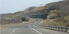
Also in 1998, the Prichard, West Virginia bypass was opened to traffic with one interchange and one at-grade intersection. This four-mile (6.4 km)bypass includes very large rock cuts and a long and winding grade down a hill. In 2001, the four-lane highway was extended northward for a mile (1.6 km), removing some grades and curves along US 52. The extension was completed in 2002 at a cost of $9,613,889.26. New signage was installed in late 2002 to replace orange construction signs that date to the construction of the bypass.
Before the eastern bypass was built, US 52 inside Prichard involved two alignments. US 52 originally took the path of WV 152, approximately 10 miles (16 km) east of the current alignment. In the mid-1960s, state funding was secured to upgrade most of County Route 1 (CR 1), which ran along the Big Sandy River and Tug Fork River. The upgraded CR 1 was renumbered as US 52 in 1979. A western bypass of Prichard was constructed in the mid-1970s and partially abandoned in 1999, when the new four-lane alignment east of the community was constructed.
In 2001, the Crum segment of the Tolsia Highway opened to traffic. The highway begins just north of Crum, touching down at an incomplete diamond interchange with US 52 and heads eastward towards CR 2. It has at-grade intersections with CR 52-47 and CR 52-31 along with a side road at the eastern terminus that takes traffic to CR 2. There are stubs for future bridges and ramps. Signage along this segment is minimal, with only a handful of arrows to designate the route. While the highway was built to four-lane standards, it is only striped for two.
In late 2002, Senator Robert C. Byrd received $20 million in funds to jump-start construction on the northern half of the King Coal Highway. The money would be used to speed up construction on the 10-mile (16 km) link between Huntington and Prichard, serving several industrial parks and relieving two-lane US 52 of coal-truck congestion.
In 2003, survey and design of five miles (8.0 km) of four-lane US 52 upgrades from Prichard north to Cyrus were completed. This includes an interchange and five bridge structures. Estimated cost of construction is $90 million.
Total design work for 2003–04 on the Tolsia Highway totals over 18 miles (29 km).
Future
.svg.png)
.svg.png)
The unfunded six-year transportation plans, released by the West Virginia Department of Transportation (WVDOT) in 2005, has listed the Tolsia Highway as under several contracts.[2] The six-year priority plans also list several Tolsia Highway projects with funding estimates and details.[3]
- Upgrade US 52 to four-lanes from the WV 75 incomplete-diamond interchange south of Kenova to Sharps Branch Road in Cyrus. This 5.78-mile (9.30 km) upgrade would cost $57 million. It is listed as 36th in priority.
- Upgrade the Tolsia Highway to four-lanes from Sharps Branch Road in Cyrus to Prichard. This 5.51-mile (8.87 km) upgrade would cost $83.8 million and is 39th in priority.
- Widen the Hubbardstown to Tabors Creek Road segment of US 52, with preliminary engineering and right-of-way beginning in 2008, with construction starting in 2009. The 3.62-mile (5.83 km) four-lane highway would cost $43.75 million and is ranked 58th in priority.
- Upgrade the Tolsia Highway from Tabors Creek Road to Fort Gay on a new 4.05-mile (6.52 km) alignment at a cost of $36 million. It is ranked 52nd.
- The Fort Gay to Saltpetre Road at Saltpetre segment of US 52, with preliminary engineering beginning in 2008, is slated for construction to begin in 2010. This 3.3-mile (5.3 km) four-lane upgrade would cost $22.7 million. It is ranked 51st.
- Upgrade the Saltpetre Road at Saltpetre to Glenhayes along a new 5.16-mile (8.30 km) alignment at a cost of $37.1 million. It is ranked 60th.
- Complete the Tolsia Highway from Glenhayes to Drag Creek two miles (3 km) north of WV 152 along a new 5-mile (8.0 km) alignment. This is estimated to cost $62.4 million and is ranked 64th.
- Upgrade the Drag Creek to Crum at Jennie Creek Road alignment along US 52. The 5.73-mile (9.22 km) segment would cost $57.4 million and is ranked 65th.
- Upgrade the Crum segment at Jennie Creek Road to Stepptown along a new 5.04-mile (8.11 km) alignment at a cost of $51.3 million. It is ranked 56th in priority.
- Construct the Kermit bypass from Stepptown to Lower Burning Creek along a new 2.76-mile (4.44 km) alignment. The estimated cost is $58.3 million, with construction phases ranging from 2006 to 2007. It is ranked 68th.
- Construct the Kermit to Parsley Branch segment, with preliminary engineering set to begin in 2010 with right-of-way acquisition beginning in 2011. It is a 2.5-mile (4.0 km) upgrade with an estimated cost of $65 million. It is ranked 77th.
- Upgrade the Tolsia Highway from Parsley Branch to Naugatuck along a new 2.46-mile (3.96 km) alignment at a cost of $65 million. It is ranked 74th. This would involve a WV 65 interchange.
- Upgrade US 52 from Naugatuck to Miller Creek along a new 3.74-mile (6.02 km) four-lane alignment at an estimated cost of $53.9 million. It is ranked 83rd. This completes the Tolsia Highway to Corridor G.
Williamson Bypass
US 52 enters Kentucky twice along the Williamson, West Virginia bypass; constructing bridges across the Big Sandy was preferred because it prevented the blasting of several hillsides in West Virginia. It was completed in 1996 as part of the Corridor G (US 119) project. The speed limit in West Virginia is 65 mph (105 km/h) but abruptly drops to 55 mph (89 km/h) in Kentucky.
The Tolsia Highway is expected to meet the King Coal Highway at WV 65 and Corridor G (US 119).
King Coal Highway
The King Coal Highway is defined to run from WV 65 and Corridor G (US 119) near Belo, West Virginia to I-77 at its US 52 interchange near Bluefield.[4] I-66, Coalfields Expressway (US 121) and the Shawnee Expressway will connect to the King Coal Highway.
The travel time, currently over 120 minutes from Williamson to Bluefield, will be reduced to 87 minutes.[4] South of Ikes Fork, a two-hour trip to Bluefield will be reduced to 44 minutes.
Interchanges and intersections proposed for the King Coal Highway include:[1]
- Mingo County:
- Near Head of Isaban
- Near Taylorville, West Virginia
- Near Twisted Gun Gap, West Virginia
- Near Delbarton
- Near Sharon Heights
- Logan County:
- Horsepen Mountain at Mountain View
- McDowell County:
- Wyoming County:
- Mercer County:
- Near Crystal
- Near McComas
- Near Sandlick
- West Virginia Route 20 near Littlesburgh Road
- Near Rock
- Near Godfrey
- West Virginia Route 123 - Airport Road
- John Nash Boulevard

Construction began in 1999 on the three-level diamond interchange on Indian Ridge near Welch that will facilitate traffic between the King Coal Highway (US 52, Interstate 73/74) and the Coalfields Expressway (US 121).
Initial site work was completed in 2003, with grading evident; this required the filling in of a large valley. It will also be the site of a new state prison along with future industrial development.
Work has progressed on the four-lane upgrading of US 52 in Mercer County just east of Bluefield. On November 24, a contract totalling $2,057,914 was let to move approximately 500,000 cubic yards (380,000 m3) of dirt and to grade and drain .22 miles from the recently completed $27 million interchange with Corridor Q (US 460) east of Bluefield to US 19 just north of James P. Bailey Lake. Six buildings will be demolished. This is the first of several projects that will extend the King Coal Highway to West Virginia Route 123 (Airport Road) north of Bluefield. Extending this project east, another contract was awarded December 15 and totals $1,371,251. The contract calls for more than 200,000 cubic yards (150,000 m3) of excavation to grade and drain .18 mile of the King Coal Highway from county route 25 just north of the US 460 interchange to south of the old Raleigh-Grayson Turnpike. 36 buildings will be demolished. A future contract will include a bridge over US 19 which will cost $15 million.[5][6]
Work is set to begin on a 1.37-mile (2.20 km) stretch of roadway in Raleigh county at a cost of $12.2 million. This includes paving, guardrail installation, pavement marking, and signing operations for this segment.
Design work is being commenced on a 11-mile (18 km) segment of the King Coal Highway from Horsepen Mountain to Isaban and from the Mercer County Interchange to West Virginia Route 123/Airport Road. The work being done on a 2.5-mile (4.0 km) section of highway near Horsepen Mountain is being done by mining companies that will save taxpayers over $20 million.
The total cost for both the Tolsia and King Coal Highways will be over $2 billion.
Major intersections
| County | Location | mi | km | Destinations | Notes |
|---|---|---|---|---|---|
| Mercer | | Virginia state line (East River Mountain Tunnel through East River Mountain); southern end of I-77 overlap | |||
| Bluefield | Northern end of I-77 overlap; US 52 north follows exit 1 | ||||
| | Interchange; southern end of US 460 overlap | ||||
| Bluefield | Northern end of US 460 overlap | ||||
| Southern end of US 19 overlap | |||||
| Northern end of US 19 overlap | |||||
| Brush Fork | |||||
| Bluewell | |||||
| Bramwell | |||||
| McDowell | Elkhorn | ||||
| Welch | |||||
| Southern end of WV 16 overlap | |||||
| Northern end of WV 16 overlap | |||||
| Iaeger | Southern end of WV 80 overlap | ||||
| Wyoming | Hanover | ||||
| Mingo | Gilbert | Northern end of WV 80 overlap | |||
| Mountain View | Southern end of WV 44 overlap | ||||
| | Northern end of WV 44 overlap | ||||
| | Southern end of WV 65 overlap | ||||
| | |||||
| Delbarton | Northern end of WV 65 overlap | ||||
| Williamson | |||||
| Southern end of US 119 overlap | |||||
| Pike (Kentucky) | | ||||
| Mingo | | ||||
| Pike (Kentucky) | | Interchange | |||
| Mingo | Nolan | To Nolan Toll Bridge | |||
| | Northern end of US 119 overlap | ||||
| Naugatuck | |||||
| Kermit | To Kermit Bridge | ||||
| Wayne | | ||||
| | |||||
| Fort Gay | Southern end of WV 37 overlap | ||||
| | Northern end of WV 37 overlap | ||||
| | Interchange | ||||
| | Southern end of WV 75 overlap | ||||
| Kenova | Northern end of WV 75 overlap; southern end of I-64 overlap; US 52 south follows exit 1 | ||||
| Cabell | Huntington | Northern end of I-64 overlap; US 52 north follows exit 6 | |||
| Madison Avenue - VA Medical Center | Interchange; northbound exit and southbound entrance | ||||
| Interchange | |||||
| Ohio state line (West Huntington Bridge over Ohio River) | |||||
| 1.000 mi = 1.609 km; 1.000 km = 0.621 mi | |||||
References
- 1 2 Mitchem, Mike; Akers, David B. (n.d.). King Coal Highway, I-73/74 Authority. Gilbert: West Virginia Department of Highways.
- ↑ "Six Year Highway Improvement Program: Unfunded Projects" (PDF). West Virginia Department of Transportation. June 22, 2005. Archived from the original (PDF) on September 20, 2006. Retrieved August 7, 2006.
- ↑ West Virginia Department of Transportation (November 1, 2006). "Priority Average Composite" (XLS). 6-Year Plan. West Virginia Department of Transportation. Sheet 1.
- 1 2 West Virginia Department of Transportation (n.d.). "Executive Summary.". King Coal Highway. n.p.: West Virginia Department of Transportation.
- ↑ West Virginia Department of Transportation (December 18, 2003). "DOH Awards King Coal Highway Contract" (Press release). West Virginia Department of Transportation. Retrieved December 24, 2003.
- ↑ "Contract Allows More King Coal Highway Construction". Bluefield Daily Telegram. December 20, 2003. Retrieved December 24, 2003.
External links
| Previous state: Ohio |
West Virginia | Next state: Virginia |
| Previous state: Virginia |
West Virginia | Next state: Ohio |
| Previous state: Ohio |
West Virginia | Next state: Virginia |