Kenova, West Virginia
| Kenova, West Virginia | |
|---|---|
| City | |
 Location of Kenova, West Virginia | |
| Coordinates: 38°23′59″N 82°34′43″W / 38.39972°N 82.57861°WCoordinates: 38°23′59″N 82°34′43″W / 38.39972°N 82.57861°W | |
| Country | United States |
| State | West Virginia |
| County | Wayne |
| Government | |
| • Type | Strong Mayor / Council |
| • Mayor | Lonnie T "Terry" Carpenter |
| Area[1] | |
| • Total | 1.60 sq mi (4.14 km2) |
| • Land | 1.26 sq mi (3.26 km2) |
| • Water | 0.34 sq mi (0.88 km2) |
| Elevation | 558 ft (170 m) |
| Population (2010)[2] | |
| • Total | 3,216 |
| • Estimate (2012[3]) | 3,142 |
| • Density | 2,552.4/sq mi (985.5/km2) |
| Time zone | Eastern (EST) (UTC-5) |
| • Summer (DST) | EDT (UTC-4) |
| ZIP code | 25530 |
| Area code(s) | 304 |
| FIPS code | 54-43180[4] |
| GNIS feature ID | 1541155[5] |
| Website | http://www.cityofkenova.com |

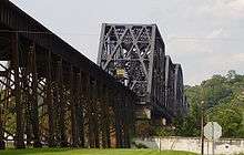
Kenova is a city in Wayne County, West Virginia, at the confluence of the Ohio and Big Sandy Rivers. Located near a tristate border, the city's name is a portmanteau of Kentucky, Ohio, and West Virginia (W. Va).[6] Founded in 1859 but not incorporated until 1894, the town's early history and development was centered on the railroad industry. It is home to a major Norfolk Southern Ohio River Bridge. CSX Transportation's former Chesapeake and Ohio Kanawha Subdivision travels through the town as well.
The population was 3,216 at the 2010 census. Kenova is a part of the Huntington-Ashland, WV-KY-OH, Metropolitan Statistical Area (MSA). As of the 2010 census, the MSA had a population of 287,702. New definitions from February 28, 2013 placed the population at 363,000.[7]
The city is also near the site of the Southern Airways Flight 932 aviation disaster. In 1970, a plane carrying the Marshall University football team crashed on a hillside on approach to the Tri-State Airport, killing all on board. A movie about the tragedy, We Are Marshall, was released in 2006.
Education
Since the closing of Ceredo-Kenova and Buffalo-Wayne High Schools in 1998, Kenova Elementary is the lone public education facility within Kenova city limits. The school has been awarded multiple national blue ribbons in academic achievement. Buffalo Elementary and Buffalo Middle schools are also located near Kenova, but just outside city limits. The former Ceredo-Kenova High School, locally known as "C-K," boasted a great number of athletic state championships, including 12 in football, two in basketball, one in cheerleading and in 1995 won their only WV State Class A Region 4 Baseball championship. Buffalo can credit championships in boys' and girls' basketball and in football to their accomplishments. In 1998, Ceredo-Kenova and Buffalo-Wayne High Schools were closed and consolidated with Huntington-based Vinson High School to form Spring Valley High School. The former Vinson High School is now known as Vinson Middle School. In 2015 the former Ceredo-Kenova High School was demolished.
Geography
According to the United States Census Bureau, the city has a total area of 1.60 square miles (4.14 km2), of which, 1.26 square miles (3.26 km2) is land and 0.34 square miles (0.88 km2) is water.[1]
Demographics
| Historical population | |||
|---|---|---|---|
| Census | Pop. | %± | |
| 1900 | 863 | — | |
| 1910 | 992 | 14.9% | |
| 1920 | 2,162 | 117.9% | |
| 1930 | 3,680 | 70.2% | |
| 1940 | 3,902 | 6.0% | |
| 1950 | 4,320 | 10.7% | |
| 1960 | 4,577 | 5.9% | |
| 1970 | 4,860 | 6.2% | |
| 1980 | 4,454 | −8.4% | |
| 1990 | 3,748 | −15.9% | |
| 2000 | 3,485 | −7.0% | |
| 2010 | 3,216 | −7.7% | |
| Est. 2015 | 3,083 | [8] | −4.1% |
| Source: [9] | |||
2010 census
As of the census[2] of 2010, there were 3,216 people, 1,441 households, and 868 families residing in the city. The population density was 2,552.4 inhabitants per square mile (985.5/km2). There were 1,645 housing units at an average density of 1,305.6 per square mile (504.1/km2). The racial makeup of the city was 98.8% White, 0.2% African American, 0.3% Native American, 0.1% Asian, 0.1% from other races, and 0.7% from two or more races. Hispanic or Latino of any race were 1.0% of the population.
There were 1,441 households of which 29.3% had children under the age of 18 living with them, 38.0% were married couples living together, 16.7% had a female householder with no husband present, 5.6% had a male householder with no wife present, and 39.8% were non-families. 35.6% of all households were made up of individuals and 16.3% had someone living alone who was 65 years of age or older. The average household size was 2.22 and the average family size was 2.84.
The median age in the city was 40.6 years. 22.1% of residents were under the age of 18; 8% were between the ages of 18 and 24; 24.8% were from 25 to 44; 26.6% were from 45 to 64; and 18.6% were 65 years of age or older. The gender makeup of the city was 45.8% male and 54.2% female.
2000 census
As of the census[4] of 2000, there were 3,485 people, 1,594 households, and 996 families residing in the city. The population density was 2,887.9 people per square mile (1,112.0/km²). There were 1,767 housing units at an average density of 1,464.3 per square mile (563.8/km²). The racial makeup of the city was 99.23% White, 0.23% African American, 0.17% Native American, 0.06% Asian, 0.03% from other races, and 0.29% from two or more races. Hispanic or Latino of any race were 0.20% of the population.
There were 1,594 households out of which 24.5% had children under the age of 18 living with them, 43.3% were married couples living together, 14.9% had a female householder with no husband present, and 37.5% were non-families. 34.8% of all households were made up of individuals and 15.9% had someone living alone who was 65 years of age or older. The average household size was 2.18 and the average family size was 2.77.
In the city the population was spread out with 20.5% under the age of 18, 9.0% from 18 to 24, 25.7% from 25 to 44, 24.6% from 45 to 64, and 20.1% who were 65 years of age or older. The median age was 41 years. For every 100 females there were 83.7 males. For every 100 females age 18 and over, there were 81.0 males.
The median income for a household in the city was $23,342, and the median income for a family was $29,688. Males had a median income of $27,656 versus $22,500 for females. The per capita income for the city was $16,485. About 14.5% of families and 18.6% of the population were below the poverty line, including 26.4% of those under age 18 and 12.6% of those age 65 or over.
Dreamland Pool
Dreamland Pool, first opened in 1926, was once the largest swimming pool in the United States east of the Mississippi River, measuring 250 feet (76 m) by 125 feet (38 m). The original construction included a three story pavilion that ran the length of the pool. The top floor of the pavilion included a dance floor, where many notable Big Bands played though the 1930s and 1940s and attracted big names such as Benny Goodman, Louis Armstrong, and Frank Sinatra.[10] A fire in 1972 destroyed the pavilion, but the rest of the facility survived. The pool was conveyed to the City of Kenova in 1973. Presently, the Kenova Parks & Recreation Board oversees the operation and management of the facility. About the size of a football field, Dreamland sports two cement floats equidistant from each other in the middle of the pool to allow swimmers a place to rest. Dreamland Pool was recently renovated in 2015.
The Pumpkin House
The 1891 Victorian home located at 748 Beech Street is listed on the National Register of Historic Places and was once visited by President Grover Cleveland. In recent years it has become known as The Pumpkin House, because of the more than 3000 hand-carved Jack-o-Lanterns which owner Ric Griffith, the town's previous mayor and current pharmacist, adorn it with each Halloween season. The Pumpkin House has received national media attention and has been featured on segments of NBC's The Today Show, The Ellen DeGeneres Show, and many other media outlets. Pumpkin house owner Ric Griffith is also longtime owner of the Griffith and Feil Drug Store, an old time drug store with an authentic early 20th century soda fountain which he has totally restored. His father, longtime Kenova businessman and resident Dick Griffith, worked in the pharmacy on a semi-retirement basis for many years until he was in his early 90s. He also sponsored a tennis tournament which bears his name in nearby Huntington.
Notable people
- Michael W. Smith - musician, pastor, actor
- Don Robinson - Major League baseball pitcher
- Jeff Baldwin- Major League baseball player
- Brad D. Smith- President and CEO of Intuit, Inc.[11]
See also
References
- 1 2 "US Gazetteer files 2010". United States Census Bureau. Retrieved 2013-01-24.
- 1 2 "American FactFinder". United States Census Bureau. Retrieved 2013-01-24.
- ↑ "Population Estimates". United States Census Bureau. Retrieved 2013-06-26.
- 1 2 "American FactFinder". United States Census Bureau. Retrieved 2008-01-31.
- ↑ "US Board on Geographic Names". United States Geological Survey. 2007-10-25. Retrieved 2008-01-31.
- ↑ Remington, Frank L. (Sep 8, 1969). "Take a Good Look at the US Map. Towns Have the Craziest Names". The Milwaukee Journal. p. 2. Retrieved 18 May 2015.
- ↑ "Population statistics" (PDF).
- ↑ "Annual Estimates of the Resident Population for Incorporated Places: April 1, 2010 to July 1, 2015". Retrieved July 2, 2016.
- ↑ "Census of Population and Housing". U.S. Census Bureau. Retrieved 3 June 2015.
- ↑ WSAZ news. "Dreamland Pool Opens Saturday". Retrieved 2008-07-03.
One local pool in our region is now on the road to a comeback after nearly closing.
- ↑ http://www.intuit.com/company/executives/brad_smith/
External links
Municipalities and communities of Wayne County, West Virginia, United States | ||
|---|---|---|
| Cities | 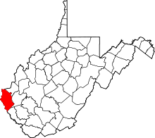 | |
| Towns | ||
| CDPs | ||
| Unincorporated communities |
| |
| Footnotes | ‡This populated place also has portions in an adjacent county or counties | |
| Principal cities | 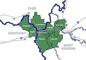 | |
|---|---|---|
| Municipalities with population over 5,000 | ||
| Municipalities with population 1,000–5,000 | ||
| Municipalities with population under 1,000 | ||
| West Virginia counties | ||
| Kentucky counties | ||
| Ohio counties | ||